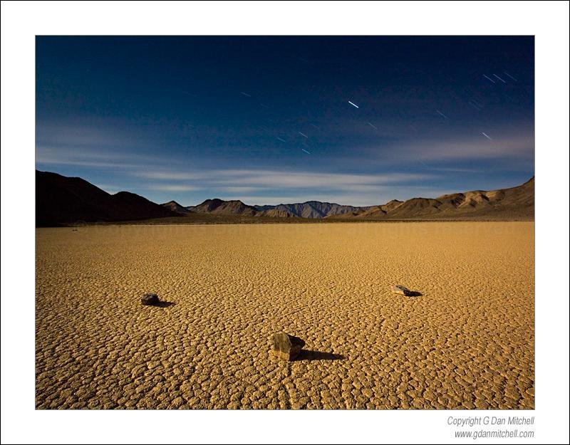
Three Rocks, Moonlight – Racetrack Playa. Death Valley National Park. March 2, 2007. © Copyright G Dan Mitchell.
I just got a “Flickr Mail” from John:
Noticed you had some recent photos of The Racetrack in Death Valley. I was in the area and tried to get there from the south, but the road was too rough for my rental car. Was wondering if you got there via the dirt path from the north, or from the south? Wondering if the north road is any better…
Thanks for writing, John. Yes, the Racetrack is an amazing and very beautiful place!
All access to the Racetrack is via some pretty rough dirt/gravel roads. The most popular approach comes in from more or less the north. From near Scotty’s Castle, take the short paved road to the Ubehebe Crater area. Near the Crater there is an intersection where the gravel road heads off towards Teakettle Junction and eventually the Racetrack.
The distance to the playa via this approach is something like 27 miles. Every time I have driven there portions of the road have been very badly washboarded. While a few (maniacal?) drivers simply go faster in these conditions, I slow down. So it takes me a couple hours to work my way out to the south end of the playa.
About this road, I believe that the official Park Service recommendation says something along the lines of “recommended for four-wheel drive, high clearance vehicles.” As long as the weather is good – and you don’t try to drive too fast – I think that the “clearance” part of this is more important than the 4WD part. I’ve driven it in a 4WD Dodge Durango and my current AWD Subaru Outback. Although I wouldn’t want to try it and I certainly don’t recommend it, I have seen minivans and even sedans out there.
I have not driven in from the south approach that I think you are describing. I have heard that portions of that road are more difficult than the standard approach, though this past season one visitor told me (though I cannot verify it) that it isn’t as bad as it used to be – supposedly it is wider now that Park staff are driving Hummers (the macho military version) on the back country roads. Count this as a mere rumor.
There is a small official camping area a mile or two south of the playa, though it is little more than a couple turn-outs and a crude pit toilet. There is no drinking water here or anywhere else on or near the playa. I have camped there, though many people seem to sleep in their vehicles in one of the parking areas at the playa.
Most of the moving rock photos you have seen were likely shot at the south end of the playa. From the parking area walk perhaps 10-15 minutes out onto this end of the playa and you will begin to encounter the rocks, which seem to originate from a rocky hill at the south end of the playa.

The Source. Death Valley National Park, California. April 3, 2007. © Copyright G Dan Mitchell.
There are other things to photograph on and around the playa. “The Grandstand” is a marvelous rock structure out in the middle of the playa – you’ll see it clearly as you approach. This can be an interesting feature to photograph in the late afternoon before the best light for photographing the moving rocks at the sound end.

The Grandstand, Racetrack Playa. Death Valley National Park. April 2, 2007. © Copyright G Dan Mitchell.
The mountains around the playa are also quite beautiful in the early and late light, especially if you are fortunate enough to be there when there are clouds.

Crossing Tracks, Racetrack Playa. Death Valley National Park. April 4, 2007. © Copyright G Dan Mitchell.
If you are going to the trouble of driving nearly 60 dirt road miles to the playa, do plan to be there for sunset and sunrise. I almost feel sorry for folks who spend 4 hours driving this road, only to spend an hour or two there in the harsh midday light. Another hint: if you are a night photographer, spend some time during the day locating interesting features and then return to the playa after dark on a full moon night.

Moving Rock, Moonlight, Racetrack Playa. Death Valley National Park, California. April 2, 2007. © Copyright G Dan Mitchell.
It probably goes without saying, but I’ll say it anyway – this is not a place you’ll want to go in the summer. My visits have all been in early April and even then it can be quite hot and dry. On the other hand, I’ve seen light snow out there as well. Be prepared for a wide variety of possible conditions. I’d like to go earlier in the season sometime, and I hear that winter is also good.
Conditions can change quickly out there. Depending upon the time of year and the current situation you could see hot and dry weather, snow, high winds, or even flash floods. I urge all visitors to check on current conditions with Park Service personnel before heading out to the playa or any other back-country areas of Death Valley.
I hope you get out there soon and come back with great photographs!
Like this:
Like Loading...
