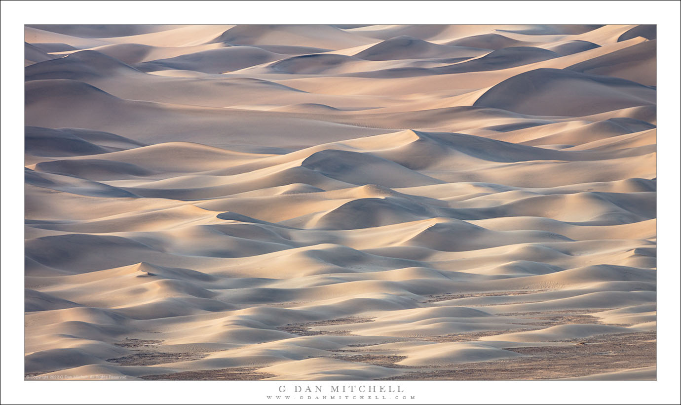
Tag Archives: low

Evening, Wildfire Smoke, Tomales Bay

Evening, Wildfire Smoke, Tomales Bay
Wildfire smoke from northern California wildfires colors the evening sky at upper Tomales Bay

Evening, Wildfire Smoke, Tomales Bay. Near Point Reyes National Seashore, California. October 15, 2017. © Copyright 2017 G Dan Mitchell – all rights reserved.

Wildfire smoke from northern California wildfires colors the evening sky at upper Tomales Bay

In what is perhaps an example of astonishingly bad timing, we were in the region just north of San Francisco for the past few days — near the areas afflicted by the terrible wildfires that have taken lives, destroyed property, and burned over huge swathes of wild land and agricultural areas. The scope of the damage is virtually unprecedented in California, and the events are not yet over as I write this. We were in Petaluma on Friday and most of Saturday, where Patty was to participate in a long-planned wedding of one of her former oboe students. The fires were close enough to Petaluma that breathing masks were provided to those attending the wedding, and at times ash fell from the sky like very light snow flurries.

On Saturday we moved closer to Point Reyes National Seashore. Our original plan had been to spend a couple of days photographing there, but the conditions were not conducive to photography for the most part. We visited the Seashore on Sunday, but the smoke and the naturally brown October conditions, combined with a complete lack of moody for or other clouds left us a bit uninspired. We found a few things to photograph, but we finally decided to just drive north up that coast a ways. We got just past Jenner, where the smoke become even thicker — and we turned around. The smoke was not the only evidence of the fires. Signs were up everywhere — restaurants and similar places — with announcements of fund-raisers, requests for donation, notes from people looking for a place to stay. It was also clear the folks from inland had headed out toward the ocean to try to escape the fires. We left Jenner and headed back toward our lodgings in the Point Reyes area, and just at sunset we arrived at upper Tomales Bay. It was quiet and still as we stopped at a high point from which we could look out over the bay and north toward its mouth. It was still smokey, but here the smoke merely softened the features of the landscape and added color to the sky and the reflecting water.


G Dan Mitchell is a California photographer and visual opportunist. His book, “California’s Fall Color: A Photographer’s Guide to Autumn in the Sierra” is available from Heyday Books and Amazon.
Blog | About | Flickr | Twitter | FacebookGoogle+ | LinkedIn | Email


All media © Copyright G Dan Mitchell and others as indicated. Any use requires advance permission from G Dan Mitchell.

Pier, Low Tide

Pier, Low Tide
A pier extends across tidal flats at the edge of Tomales Bay, Inverness, California

Pier, Low Tide. Inverness, California. July 23, 2017. © Copyright 2017 G Dan Mitchell – all rights reserved.

A pier extends across tidal flats at the edge of Tomales Bay, Inverness, California

In late July I took a day to visit Point Reyes. My main goal was a long hike over the barren bluffs above Drakes Estero, with my plan being to follow a route all the way to the coast at Drakes Bay, hopefully arriving at just about the time the fog cleared. It was a wonderful hike, with some clearing early on, but ultimately it never did clear at the coast. On a day when merely a few miles inland the temperatures rose into the 90 degree range, here in the fog and wind it never got out of the fifties, and it was almost like enjoying a winter day in July.

Before I began my hike I drove along the shore of long, narrow Tomales Bay, where the road mostly travels right along the shoreline, often only feet from the water. This bay is very sheltered, with a narrow entrance and then a long distance from there to its inner reaches. At the upper end the tides regularly turn the bay into a mudflat. I always am on the lookout for photographs as I drive this route, and as I passed this spot I caught a glimpse of the stark backlight and the brilliant reflections on the mudflat — so I turned around and headed back to make a few pictures of this pier and the building out over the way.


G Dan Mitchell is a California photographer and visual opportunist. His book, “California’s Fall Color: A Photographer’s Guide to Autumn in the Sierra” is available from Heyday Books and Amazon.
Blog | About | Flickr | Twitter | FacebookGoogle+ | LinkedIn | Email


All media © Copyright G Dan Mitchell and others as indicated. Any use requires advance permission from G Dan Mitchell.

Low Tide, Fog, Drakes Estero

Low Tide, Fog, Drakes Estero
Thinning fog above Drakes Estero at low tide

Low Tide, Fog, Drakes Estero. Point Reyes National Seashore, California. July 23, 2017. © Copyright 2017 G Dan Mitchell – all rights reserved.

Thinning fog above Drakes Estero at low tide

I spend a mid-July day hiking — at least once I had completed my obligatory bakery stop at Point Reyes Station — a route at Point Reyes National Seashore that I’ve had my eyes on for some time. It is a trail that starts in the upper recesses of Drakes Estero and, if you turn at the right junctions, finally goes all the way to headlands above Drakes Bay. I had, in fact, started this hike at least once in the past, but always a bit spontaneously and too late in the day, and each time I had turned back before completing it. This time I planned more carefully, and I was on the trail in plenty of time to complete the round trip.

This is a spare landscape, mostly without the vertical scale of places like the Sierra or even of the Big Sur coastline. Bare bluffs run along the peninsula that runs out toward the actual “point,” and the view extends more in the horizontal than the vertical direction. But what it lacks in vertical relief, this landscape can make up for as a canvas on which effects of atmosphere and light may play. My plan was to begin my hike at about the time the morning fog broke up, and to then follow the fog/sun line as in moved toward the coast. I was not entirely successful (it never did clear at the coast) but I timed it just about right for the start of the walk. This photograph comes from that early section of the route, when the clear sky above the dissipating clouds reflected its blue color onto the waters of the estero.


G Dan Mitchell is a California photographer and visual opportunist. His book, “California’s Fall Color: A Photographer’s Guide to Autumn in the Sierra” is available from Heyday Books and Amazon.
Blog | About | Flickr | Twitter | FacebookGoogle+ | LinkedIn | Email


All media © Copyright G Dan Mitchell and others as indicated. Any use requires advance permission from G Dan Mitchell.

Low Tide, Drakes Estero

Patterns emerge and reflect the sky at low tide on a foggy morning at Drakes Estero

Low Tide, Drakes Estero. Point Reyes National Seashore, California. July 23, 2017© Copyright 2017 G Dan Mitchell – all rights reserved.

Patterns emerge and reflect the sky at low tide on a foggy morning at Drakes Estero

Although I have been visiting the Point Reyes National Seashore, just north of San Francisco, for quite a few years, it has sometimes been a challenging place for me to photograph. Perhaps it is because, with some exceptions, it generally doesn’t feature the same sorts of iconic and spectacular Pacific coast subjects found in places such as the Big Sir coast. instead there are coastal lowlands with most-treeless bluffs, thick and impenetrable forests further inland, and grand vistas across low-lying landscapes. But given enough time and patience and persistence, I think ti begins to be possible to discover a way of seeing almost any landscape, and I’m starting to understand how to see this place.

I knew it that there would be fog on this visit, and my plan/hope was that I could get there at the right time to place myself along the boundary between sun and fog, where interesting things often happen with the light. I decided to take a rather long hike (about 13 miles roundtrip) to a location that I have long wanted to visit, and I arrived at the trailhead just as the fog was beginning to thin there. After dropping through forest I arrived and crossed one arm of Drakes Estero as the tide was at its low point, revealing mud flats along the shoreline. The trail climbed again and I came around another high headland to see a more expansive view toward the fog over the ocean to the west. The low tide revealed remarkable patterns in the estero, and the shallow water reflected the deep blue sky and the thinning fog clouds.


G Dan Mitchell is a California photographer and visual opportunist. His book, “California’s Fall Color: A Photographer’s Guide to Autumn in the Sierra” is available from Heyday Books and Amazon.
Blog | About | Flickr | Twitter | FacebookGoogle+ | LinkedIn | Email


All media © Copyright G Dan Mitchell and others as indicated. Any use requires advance permission from G Dan Mitchell.