
Upper Titus Canyon. Death Valley National Park, California. April 1, 2014. © Copyright 2014 G Dan Mitchell – all rights reserved.
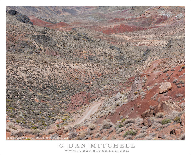
Titus Canyon road descends into the upper canyon from Red Pass, Death Valley National Park
At first glance this landscape lacks a central focus and the colors are relatively unsaturated. The contrasts within the terrain are subdued, without the striking divisions between light and shadow that we might see in places like the alpine zones of the Sierra. In the past I have often not bothered to photograph such places, since they appear to lack the dramatic qualities that we often search out in a place like Death Valley. And there is no questioning the appeal of those subjects that possess starker lines, brighter colors, greater contrast, and perhaps towering geological forms. Yet, it occurred to me a year or two ago that the places like this are part of the true experience of the desert and of Death Valley, and that their character is a big part of what forms my sense of this terrain. To ignore them seems both a bit unfair and a bit dishonest. So I decided to try to see if I could find ways to photograph them, a project I’m still working on but also one on which I’m confident that I’m making some progress—and, in the process, learning to see the place more fully.
This photograph was made at Red Pass, the high point of the Titus Canyon road between the Amargosa Valley and Death Valley. (The source of the the name of this pass is probably obvious from one look at the color of the rocks.) The narrow, twisty, one-way gravel road is perhaps best known for traveling through very narrow slot canyon terrain near its lower end, but the whole thing is part of the experience. After a steep climb out of the upper reaches of Titanothere Canyon, the road tops the narrow ridge of the pass before descending steeply into the upper reaches of Titus Canyon. The view from the pass down into upper Titus Canyon is remarkable. The canyon drops away and the road is visible twisting and turning its way down the initial descent and then crossing flatter areas beyond. Barely visible in the upper left area of the image is the location of the historic ghost town of Leadville, a town built on the false promises of mineral wealth that great and then died in the space of about a year—in a place that could hardly be more remote or less hospitable.
 G Dan Mitchell is a California photographer and visual opportunist whose subjects include the Pacific coast, redwood forests, central California oak/grasslands, the Sierra Nevada, California deserts, urban landscapes, night photography, and more.
Blog | About | Flickr | Twitter | Facebook | Google+ | 500px.com | LinkedIn | Email
Text, photographs, and other media are © Copyright G Dan Mitchell (or others when indicated) and are not in the public domain and may not be used on websites, blogs, or in other media without advance permission from G Dan Mitchell.