Tag Archives: amargosa

Telescope Peak

Telescope Peak
Telescope Peak

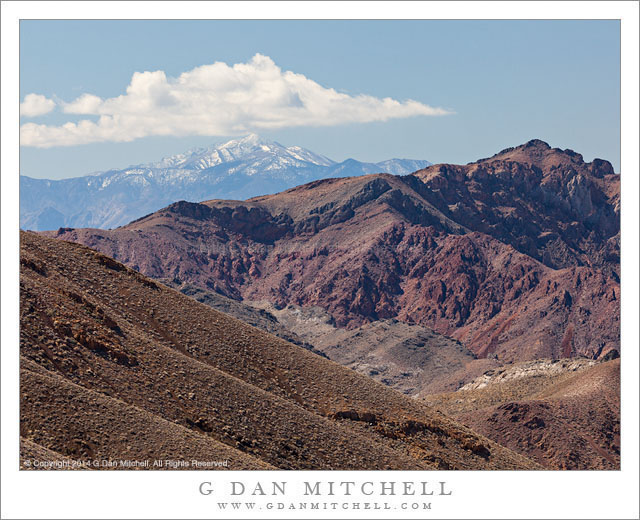
Telescope Peak. Death Valley National Park, California. April 1, 2014. © Copyright 2014 G Dan Mitchell – all rights reserved.

Telescope Peak, the highest point in Death Valley National Park, in the distance beyond the rugged terrain of upper Titanothere Canyon in the Amargosa Range

This one has been sitting in my queue for months now, and it is finally time to send it out with the other photographs! I made the photograph back in early April, while spending a few days in Death Valley exploring a lot of higher elevation area in the mountains on either side of the Valley itself. At one point during this visit, we ended up spending nearly an entire day high up in the Panamint range, at times doing something very unusual — photographing Death Valley wildflowers during a snowstorm!

The distant snow-covered peak in the photograph is Telescope Peak, at over 11,000′ of elevation the highest point in the Panamint range and in Death Valley National Park. While we often think of Death Valley’s reputation for heat, this peak is often covered with snow during the colder times of the year. The location from which I made this photograph is high in the mountains on the other, east side of the Valley, a very arid and rugged region that presents a different appearance than the much lower areas of the Valley itself. Here there is a landscape of dry and rugged mountains and valleys, often receding one behind the other into the distance. I stopped at this spot, where I have photographed before, and was captivated by the conduction of three peak shapes — the nearly peak at upper right, the distant summit of Telegraph Peak, and the peak-like form of the clouds above.

G Dan Mitchell is a California photographer and visual opportunist whose subjects include the Pacific coast, redwood forests, central California oak/grasslands, the Sierra Nevada, California deserts, urban landscapes, night photography, and more.
Blog | About | Flickr | Twitter | FacebookGoogle+ | 500px.com | LinkedIn | Email

Text, photographs, and other media are © Copyright G Dan Mitchell (or others when indicated) and are not in the public domain and may not be used on websites, blogs, or in other media without advance permission from G Dan Mitchell.

Red Rock Towers

Red Rock Towers
Red Rock Towers

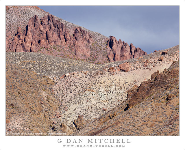
Red Rock Towers. Death Valley National Park, California. April 1, 2014. © Copyright 2014 G Dan Mitchell – all rights reserved.

A band of red rock towers high on a ridge in the Amargosa Range, Death Valley National Park

This is another in what might be termed the “Unspectacular Death Valley” series. ;-) As I have mentioned before, most of the terrain of this park and of similar places does not consist of high contrast, intensely colorful scenery. In reality, the color palette of much of the park is quite subtle, consisting primarily of tans and grays, with dark shadows, some reddish rock, occasionally other colors of rock, and few brilliantly colorful plants. (An exception may occur during a short period in a spring that follows an unusually wet winter, when some areas my show profuse wildflower blooms. And, of course, when shooting in golden hour light almost any landscape can become much more intense.) Over time I have come to like being in this seemingly plain landscape, even in the middle of the day.

These formations, some red rock outcroppings just below a ridge at the head of a small valley, are in an area I have visited a number of times. I’ve looked up at them and wondered how I could photograph them. This time I got a bit of help from the weather. The overall light was softened a bit by clouds, and the same cloud system gave me a darker gray sky beyond the ridge rather than the more typical plain blue sky. All of this brings out the color of the red rocks—which feel like a small, far-west outpost of Utah!—and allow the subtle colors of the vegetation to be just a bit clearer.

G Dan Mitchell is a California photographer and visual opportunist whose subjects include the Pacific coast, redwood forests, central California oak/grasslands, the Sierra Nevada, California deserts, urban landscapes, night photography, and more.
Blog | About | Flickr | Twitter | FacebookGoogle+ | 500px.com | LinkedIn | Email

Text, photographs, and other media are © Copyright G Dan Mitchell (or others when indicated) and are not in the public domain and may not be used on websites, blogs, or in other media without advance permission from G Dan Mitchell.
Upper Titus Canyon

Upper Titus Canyon
Upper Titus Canyon

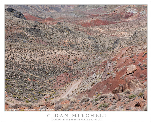
Upper Titus Canyon. Death Valley National Park, California. April 1, 2014. © Copyright 2014 G Dan Mitchell – all rights reserved.

Titus Canyon road descends into the upper canyon from Red Pass, Death Valley National Park

At first glance this landscape lacks a central focus and the colors are relatively unsaturated. The contrasts within the terrain are subdued, without the striking divisions between light and shadow that we might see in places like the alpine zones of the Sierra. In the past I have often not bothered to photograph such places, since they appear to lack the dramatic qualities that we often search out in a place like Death Valley. And there is no questioning the appeal of those subjects that possess starker lines, brighter colors, greater contrast, and perhaps towering geological forms. Yet, it occurred to me a year or two ago that the places like this are part of the true experience of the desert and of Death Valley, and that their character is a big part of what forms my sense of this terrain. To ignore them seems both a bit unfair and a bit dishonest. So I decided to try to see if I could find ways to photograph them, a project I’m still working on but also one on which I’m confident that I’m making some progress—and, in the process, learning to see the place more fully.

This photograph was made at Red Pass, the high point of the Titus Canyon road between the Amargosa Valley and Death Valley. (The source of the the name of this pass is probably obvious from one look at the color of the rocks.) The narrow, twisty, one-way gravel road is perhaps best known for traveling through very narrow slot canyon terrain near its lower end, but the whole thing is part of the experience. After a steep climb out of the upper reaches of Titanothere Canyon, the road tops the narrow ridge of the pass before descending steeply into the upper reaches of Titus Canyon. The view from the pass down into upper Titus Canyon is remarkable. The canyon drops away and the road is visible twisting and turning its way down the initial descent and then crossing flatter areas beyond. Barely visible in the upper left area of the image is the location of the historic ghost town of Leadville, a town built on the false promises of mineral wealth that great and then died in the space of about a year—in a place that could hardly be more remote or less hospitable.

G Dan Mitchell is a California photographer and visual opportunist whose subjects include the Pacific coast, redwood forests, central California oak/grasslands, the Sierra Nevada, California deserts, urban landscapes, night photography, and more.
Blog | About | Flickr | Twitter | FacebookGoogle+ | 500px.com | LinkedIn | Email

Text, photographs, and other media are © Copyright G Dan Mitchell (or others when indicated) and are not in the public domain and may not be used on websites, blogs, or in other media without advance permission from G Dan Mitchell.
Desert Mountains, Stormy Sunrise

Desert Mountains, Stormy Sunrise

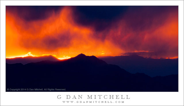
Desert Mountains, Stormy Sunrise. Death Valley National Park, California. April 2, 2014. © Copyright 2014 G Dan Mitchell – all rights reserved.

Sun rises through the clouds of a developing storm over the Amargosa Range, Death Valley National Park

We arrived very early at this high overlook in Death Valley National Park’s Panamint Range, hoping to photograph a desert mountain sunrise. When conditions are good at this location, there is an almost 360 degree panorama of rugged and desolate mountain terrain, punctuated by deep valleys, especially the chasm of Death Valley itself which lies immediately below. Because the spot is so high, even further views abound—far out into Nevada to the east, and back to the crest of the Southern Sierra to the west.

But little of that happened on this morning. We arrived before dawn and I could tell that a cloud deck was coming over the Panamint crest behind us and extending out to the east over Death Valley. There was a gap in the clouds to the east, but it was a narrow one, and more clouds were beginning to build over the ridges in that direction. On a perfect morning here, beams of sunrise light play over the tops of the peaks and shine into valleys near and far. But on this morning things were rapidly tending toward gray. However, for a few moments there was a bit of brilliant color just over those eastward ridges, where the clouds had not yet closed down on their summits, and by using a very long lens I was able to isolate this scene just as the sun came up, backlighting the virga falling from the clouds above the silhouetted forms of the ridges.

G Dan Mitchell is a California photographer and visual opportunist whose subjects include the Pacific coast, redwood forests, central California oak/grasslands, the Sierra Nevada, California deserts, urban landscapes, night photography, and more.
Blog | About | Flickr | Twitter | FacebookGoogle+ | 500px.com | LinkedIn | Email

Text, photographs, and other media are © Copyright G Dan Mitchell (or others when indicated) and are not in the public domain and may not be used on websites, blogs, or in other media without advance permission from G Dan Mitchell.