Tag Archives: aspen

Aspens, First Autumn Snow

Aspens, First Autumn Snow
An early season storm brings snow to eastern Sierra Nevada aspen groves.

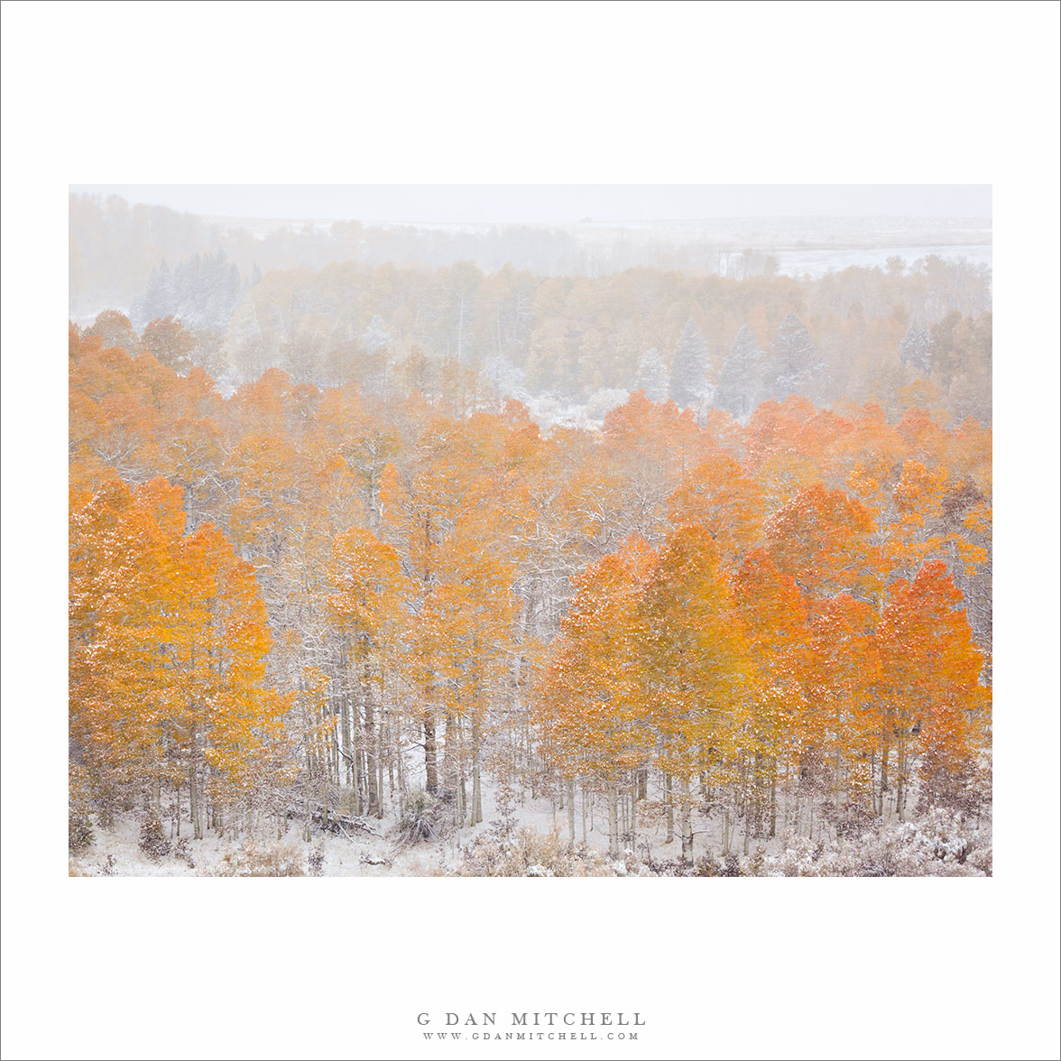
We made it to the eastern Sierra Nevada last week for the annual pilgrimage to photograph aspen color. We drove over on the day when the first winter-like storm of the season came to the range, and our travel plans changed accordingly. Normally we would cross the Sierra via Tioga Pass through Yosemite National Park. Although the Republican government shutdown closed the park, the trans-Sierra highway 120 remained open… until the night before our trip when it was closed in preparation for the forecast storm. When this pass closes – as it can often do in October, when early season storms drop a few inches of snow on the road – I have to consider options to the north: Sonora, Ebbetts, or Carson Passes. When we started out, Sonora was still open, but I figured that Carson was a better bet, as it is an all-season route. So we headed over Carson in the morning, encountering the first snow flurries well before the pass. From this point on, with the exception of a few lower elevation sections of our drive over Monitor Pass and then down highway 395 to Bishop, we were either in or near light snow.

This has been a slightly different year for aspens – though, to be honest, no two years evolve exactly the same way when it comes to the color transition. The highest trees had mostly lost their leaves, but we saw excellent color in many places all along the route. This color transition marks, for me, the reality that the warm season is over and California’s rainy, snowy, and colder season is coming. Being among the aspens during one of the first early season snow storms amplifies that effect, and we remarked on how sudden the transition was. Only a few days earlier it had been in the low 90 degree range in parts of Central California… and here we were in snow. I photographed the scene in this photograph as we reached the top of Conway Summit, the high point on highway 395 just north of the town of Lee Vining. Here one of the largest and most accessible aspen groves can provide an astonishing amount and variety of color for a few days each year. However, on this day the colors were distinctly muted by the falling snow.


Leave a comment or question using the form. (If you are reading this on the home page, click the article title to see the full article and the comment form.

G Dan Mitchell is a California photographer and visual opportunist. His book, “California’s Fall Color: A Photographer’s Guide to Autumn in the Sierra” (Heyday Books) is available directly from him. Blog | Bluesky | Mastodon | Substack Notes | Flickr | Email

All media © Copyright G Dan Mitchell and others.

Looking for Eastern Sierra Aspen Color?

Since this is the season of aspen color along the east slope of the Sierra Nevada mountains, it seems like a good time to share a link to my article on where and how to find and photograph these beautiful trees: Sierra Nevada Fall Color Season – Coming Sooner Than You Think

Fallen Aspen Branch, Snow - A small aspen tree branch blown down by an early fall storm rests on snow, North Lake, California.
Fallen Aspen Branch, Snow – A small aspen tree branch blown down by an early fall storm rests on snow, North Lake, California.

“Fallen Aspen Branch, Snow” Sierra Nevada Range, California. © Copyright G Dan Mitchell – all rights reserved.

I originally wrote this article four years ago, in response to a lot of questions about this seasonal change, and I have updated it regularly since then. The short story is that the aspens begin to change near the end of September in a typical year, and if you know where to look you can find aspen color for the next three weeks or perhaps just a bit longer. The change starts in the highest groves of trees and then works its way down to lower elevations as the transformation progresses, with later potential down along the base of the range and in some of the east side canyons.

I have not (yet) been up to photograph the trees this season – though I plan to rectify that situation very soon! – but everything I’m hearing right now suggests that the change came earlier than usual this year. In a more typical year I would expect to see the best color perhaps starting right about now and continuing for another week or longer – but this year there are a lot of reports of high elevation trees already dropping leaves and of lower elevation areas already in peak form. If you are going this year, I would make it sooner rather than later!

G Dan Mitchell is a California photographer and visual opportunist whose subjects include the Pacific coast, redwood forests, central California oak/grasslands, the Sierra Nevada, California deserts, urban landscapes, night photography, and more.
Blog | About | Flickr | Twitter | FacebookGoogle+ | 500px.com | LinkedIn | Email

Text, photographs, and other media are © Copyright G Dan Mitchell (or others when indicated) and are not in the public domain and may not be used on websites, blogs, or in other media without advance permission from G Dan Mitchell.

About the Yosemite “Rim” fire… and more

UPDATE and a NOTE:

Update: Shortly after I posted this, my reports on highway 120 through the park via the Tuolumne Meadows area  were rendered incorrect/outdated by way of an updated announcement from the park service as follows:

“Beginning at 12:00pm on Wednesday, August 28th, Tuolumne Meadows and the High Sierra will only be accessible via Highway 120 East through Lee Vining.  The Tioga Rd/Hwy 120 East will be temporarily closed between White Wolf Lodge and the Big Oak Flat Rd./Hwy 120 West at Crane Flat; the closure is estimated to be 3 to 4 days.  Tuolumne Meadows Lodge, the High Sierra Camps, and Tuolumne Meadows and Porcupine Flat campgrounds all remain open.”

Basically, this means that you will not be able to use highway 120 as a route across the Sierra until further notice. I’m not surprised – in fact, I’ve been somewhat surprised that the road remained open this long. Apparently the following URL is also a good source of updates from the park: http://www.yosemitepark.com/yosemite-fire-update.aspx

Note: All of which brings me back to my original statement that I don’t have inside information on this fire, and that anyone traveling to the area needs to check official sources for conditions updates. I will likely not update this page as things change, so the information posted here should be regarded as potentially being out of date!

My original post follows…

A few people have asked me for information about the “Rim” fire which started not far from Groveland near highway 120, and which is currently burning along the northwest boundary of Yosemite National Park, generally moving east and north toward the highway 108 area. While I know much of this area fairly well from many years (decades, actually) of visits, I do not have any inside information about the fire itself, nor am I an expert on wildfires. One good source of (limited but objective) information is the Stanislaus National Forest Rim Fire Incident web page. A map on this page is a quite amazing source of information, especially when combined with some familiarity with the area and a reading of various written reports. (The version on the main page seems to be based on Google Maps, and allows you to scroll around and zoom in.) Lots of folks who live and work in the area are sharing updates on the usual social media sites. The Mariposa Gazette is another local news source.

The fire started on August 17 more or less midway between Groveland and the  northwest park entrance and not far off of the highway 120 corridor near the Rim of the World area overlooking the canyon of the Tuolumne River. (Highway 120 is a common route for entry to the park from the west and northwest, and it connects via Tuolumne Meadows and Tioga Pass to the east side of the Sierra at the town of Lee Vining.) The spread of the fire at first was somewhat quick, which is no surprise given the extremely dry conditions in the Sierra following a second very dry winter and almost no real precipitation since late 2012. Then, between about August 20 and 23, the fire exploded, expanding  very quickly to cover a huge area generally to the east and north of the starting point, with the fire generally racing northeast but also spreading to the north and south. Continue reading About the Yosemite “Rim” fire… and more

Aspen Leaves, First Light

Aspen Leaves, First Light

Aspen Leaves, First Light. Eastern Sierra Nevada, California. October 3, 2012. © Copyright 2013 G Dan Mitchell – all rights reserved.

First morning light on aspen trees and fall foliage, eastern Sierra Nevada, California

This past fall I had exactly one day to photograph aspens in the eastern Sierra Nevada. This was a bit odd for me, since I usually spend quite a number of days chasing fall aspen color up and down the east side of the range. But this year my target was a bit further away in Utah, and we merely paused for an extra day on the “east side” on our way to that other state. Fortunately, we hit great conditions, in terms of good aspen color and fine weather that didn’t prevent us from getting up to those trees.

Very early in the morning we headed up to an area that I have photographed many times. There are a couple of iconic photographic subjects at this location, but I mostly got them out of my system some years ago and now I look for somewhat less obvious subjects when I go here. I began by shooting some trees near the outlet stream of a lake, with early morning light behind the trees. After working that tricky but beautiful light for a while, I decided to go around to the far side of the lake to where a large stand of small but densely packed aspens stands at the base of a hillside. I got there before the sun came to this spot, so I quickly schlepped my gear up the hill a ways and into the end of the grove, setting up just before the sun arrived. Before the sun’s rays hit the tree, everything had a distinctly blue tone. As the edge of the shadow arrived, the aspen leaves began to glow more and to cast shadows on the trees in the background. These shadows quickly transitioned from soft and subtle to quite contrasty and sharply defined in a matter of seconds. This photograph was made just as the sunlight arrived but before it became intense, and the soft shadows of the leaves on the slender background trunks lasted just a moment.

G Dan Mitchell is a California photographer and visual opportunist whose subjects include the Pacific coast, redwood forests, central California oak/grasslands, the Sierra Nevada, California deserts, urban landscapes, night photography, and more.
Blog | About | Flickr | Twitter | FacebookGoogle+ | 500px.com | LinkedIn | Email

Text, photographs, and other media are © Copyright G Dan Mitchell (or others when indicated) and are not in the public domain and may not be used on websites, blogs, or in other media without advance permission from G Dan Mitchell.