Tag Archives: climb

Chase Group at Top of Tunitas Road, 2009 Amgen Tour of California

Chase Group at Top of Tunitas Road, 2009 Amgen Tour of California

Chase Group at Top of Tunitas Road, 2009 Amgen Tour of California. Santa Cruz Mountains, California. February 16, 2009. © Copyright G Dan Mitchell – all rights reserved.

The chase group, led by Rock Racing with Astana’s Lance Armstrong right behind, tops the Tunitas Road climb in rain during state 2 of the 2009 Amgen Tour of California.

The lead group had arrived at the top of Tunitas Road just ahead of this chase group led by Rock Racing (likely trying to protect their rider who started the stage in the yellow jersey) and including Lance Armstrong. The stage had begun on the north side of the Golden Gate Bridge in heavy rain, travelled down the coast past Half Moon Bay, and then headed up this steep road through redwood forests to arrive at Skyline Road. Any cyclist who has ever done a long, hard ride in pouring rain can relate to the looks of the faces of these riders.

This photograph is not in the public domain. It may not be used on websites, blogs, or in any other media without explicit advance permission from G Dan Mitchell.

keywords: rock, racing, lance, armstrong, astana, tunitas road, climb, hill, summit, turn, curve, crowd, amgen, 2009, tour, of, california, usa, bicycle, bike, cycle, cyclist, race, racer, stage, road, race, rain, weather, wet, peloton, chase, group, determination, professional, pro, stock

High Sierra Trail, Big Arroyo

High Sierra Trail, Big Arroyo
High Sierra Trail, Big Arroyo. Sequoia National Park, California. August 7, 2008. © Copyright G Dan Mitchell – all rights reserved.

The High Sierra Trail crosses a small stream as it begins to climb out of Big Arroyo toward the Chagoopa Plateau.

On this day our route traveled from the old cabin in Big Arroyo out to Moraine Lake on the Chagoopa Plateau. This section of trail was near the start of the day’s walk as we began our climb out of the Arroyo, through a trail section that was often under forest cover and was crossed frequently by small creeks. I’ve been across this trail section more than once, and this time I managed to avoid being surprised by the climb. When you arrive in Big Arroyo from Kaweah Gap the view convinces you that you have nothing but downhill between there and the Kern Canyon – but you are quite wrong. The trail does follow the bottom of the Arroyo for a few miles, but then it climbs – more steadily and more steeply than you might think – up the east side of the valley to reach the flat area of Chagoopa Plateau.

keywords: high, sierra, trail, nevada, california, usa, landscape, travel, hike, backpack, big arroyo, california, usa, climb, ascend, stream, creek, rock, grass, plant, tree, flower, wildflower, big arroyo, chagoopa, plateau, morning, stock, water, rock, boulder

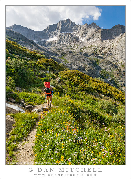
Ascending to Kaweah Gap

Ascending to Kaweah Gap

Ascending to Kaweah Gap. Sequoia National Park. August 6, 2008. © Copyright 2008 G Dan Mitchell – all rights reserved.

My friend Caroline ascends the High Sierra Trail toward Kaweah Gap above Upper Hamilton Lake in Sequoia National Park, California on the morning of the third day of a 9-day trans-Sierra pack trip from Crescent Meadow to Whitney Portal.

The High Sierra Trail crosses the entire range between Crescent Meadow in the west and Whitney Portal in the east, and travels through Sequoia National Park with the exception of the section to the east of Whitney Trail Crest. This portion above Upper Hamilton Lake ascends about 2500′ rather steeply to Kaweah Gap, a beautiful pass over the Great Western Divide by which the trail reaches Big Arroyo and the Kern River drainage.

In this photo Caroline has finished most of the very steep initial ascent above Hamilton Lake and is crossing an area of many streams and meadows and flowers shortly before arriving at Precipice Lake, from which it is only a short distance to the Gap.


G Dan Mitchell is a California photographer and visual opportunist whose subjects include the Pacific coast, redwood forests, central California oak/grasslands, the Sierra Nevada, California deserts, urban landscapes, night photography, and more.
Blog | About | Flickr | Twitter | FacebookGoogle+ | 500px.com | LinkedIn | Email

Text, photographs, and other media are © Copyright G Dan Mitchell (or others when indicated) and are not in the public domain and may not be used on websites, blogs, or in other media without advance permission from G Dan Mitchell.

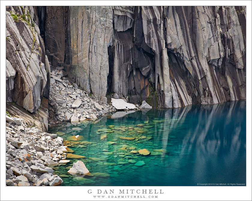
Submerged Boulders, Lake, and Cliffs

Submerged Boulders, Lake, and Cliffs
Sunlight illuminates submerged boulders near the cliff face along the High Sierra Trail – Sequioa National Park.

Submerged Boulders, Lake, and Cliffs. Sequoia National Park, California. August 6, 2008. © Copyright G Dan Mitchell – all rights reserved.

Sunlight illuminates submerged boulders near the cliff face at a lake on the High Sierra Trail – Sequioa National Park.

I first visited this lake decades ago during a two-week trans-Sierra backpack trip along the High Sierra Trail. I recall arriving and recognizing it from a well-known 1932 Ansel Adams photograph, but I made no serious attempt to photograph it at the time. In the summer of 2008 I retraced the route with a group of friends, and on the third morning I again climbed the spectacular trail toward Kaweah Gap. After crossing a lovely section filled with springs, flowing water, and wildflowers the trail topped a rise and suddenly arrived at this lake. I spent a half hour or more photographing from the shoreline. Finally I finished, packed up my photography gear, and we started up the switchbacks toward the pass.

A moment later as the trail climbed above the lake I glanced back and saw a stunning sight as sun broke through the clouds and intermittently illuminated the submerged talus at the base of the cliffs. Ironically, my first reaction was to think, I just finished shooting, and I’m not going to take this pack off and set up all that gear again!” I almost kept going. Fortunately, I’ve learned my lesson a few times — shoot it now while you have the chance! — so I dropped my pack, set up my tripod and camera, and waited for the right light to appear as broken clouds moved overhead.


Notes:

G Dan Mitchell is a California photographer whose subjects include the Pacific coast, redwood forests, central California oak/grasslands, the Sierra Nevada, California deserts, urban landscapes, night photography, and more.
Blog | About | Flickr | Twitter | FacebookGoogle+ | 500px.com | LinkedIn | Email

Text, photographs, and other media are © Copyright G Dan Mitchell (or others when indicated) and are not in the public domain and may not be used on websites, blogs, or in other media without advance permission from G Dan Mitchell.