Tag Archives: death valley

Desert Mountains, Spring Rain

Desert Mountains, Spring Rain

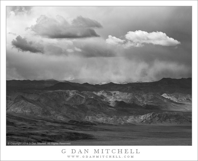
Desert Mountains, Spring Rain. Death Valley National Park, California. April 2, 2014. © Copyright 2014 G Dan Mitchell – all rights reserved.

A spring storm moves across the summit of the Cottonwood Mountains, Death Valley National Park

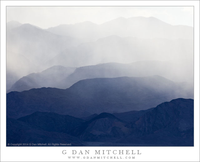
I have long been intrigued by the rising layers of ridges in the Cottonwood Mountains of Death Valley National Park. Not only do they rise dramatically from the floor of the valley, but the view of more distant peaks evokes for me thoughts and memories of more remote places in the park, ranging from well-known locations like the Racetrack Playa to less known canyons and washes. Below the range is an enormous mass of alluvial material washed down from these mountains, and the base of the range is breached by many canyons. It can be challenging to photograph since it is some distance from easy overlooks, making haze an issue, and for other reasons.

This was a day of “interesting” and diverse weather. It began with the arrival of a weather front, scattered high mountain snow flurries that eventually became steady snow in our location, soft light as the snow diminished but clouds remained, and the gradual clearing with scattered weather cells passing by. As we descended from shooting in the Panamint Mountains—where is was largely clear by this time—we looked across the wide valley at the base of the Cottonwood Mountains to see that dramatic clouds filled the sky above the range as snow and rain showers pass across its peaks and valleys.

G Dan Mitchell is a California photographer and visual opportunist whose subjects include the Pacific coast, redwood forests, central California oak/grasslands, the Sierra Nevada, California deserts, urban landscapes, night photography, and more.
Blog | About | Flickr | Twitter | FacebookGoogle+ | 500px.com | LinkedIn | Email

Text, photographs, and other media are © Copyright G Dan Mitchell (or others when indicated) and are not in the public domain and may not be used on websites, blogs, or in other media without advance permission from G Dan Mitchell.

Desert Mallow Buds

Desert Mallow Buds
Desert Mallow Buds

Desert Mallow Buds. Death Valley National Park, California. April 2, 2014. © Copyright 2014 G Dan Mitchell – all rights reserved.

Desert Mallow buds in the Panamint Mountains, Death Valley National Park

We found these flowers high in the Panamint Mountains not far from Death Valley National Park’s Emigrant Pass, though you can find them all over the park if you are there during the spring bloom. I’ve seen several names given to them: Desert Mallow, Orange Mallow, Globe Mallow. The fully developed flower opens into a goblet shape, but here we see some buds that are yet to open along with a few flowers than are just blooming.

I recently wrote that this turned out to be a pretty good wildflower year in Death Valley, perhaps to the surprise of many in the current drought-plagued period. Desert wildflowers seem to be very opportunistic, waiting if there is no water but bursting forth suddenly when it rains. Near the end of March and the beginning of April there was significant precipitation, especially in the higher elevation areas such as the Panamint Mountains. As we drove into the park we were somewhat surprised to see a lot of extensive wildflower displays, especially as we crossed Towne Pass. While there were not that many flowers on the valley floor, up high they were abundant. On this day we traveled up into the Panamints very early in the morning and then spent time wandering around and photographing various things. At one point we stopped alongside a section of the road where we spotted some large cactus plants, and we soon saw that the area was covered with all sorts of wildflowers.

G Dan Mitchell is a California photographer and visual opportunist whose subjects include the Pacific coast, redwood forests, central California oak/grasslands, the Sierra Nevada, California deserts, urban landscapes, night photography, and more.
Blog | About | Flickr | Twitter | FacebookGoogle+ | 500px.com | LinkedIn | Email

Text, photographs, and other media are © Copyright G Dan Mitchell (or others when indicated) and are not in the public domain and may not be used on websites, blogs, or in other media without advance permission from G Dan Mitchell.

Rain, Cottonwood Mountains

Rain, Cottonwood Mountains

Rain, Cottonwood Mountains. Death Valley National Park, California. April 2, 2014. © Copyright 2014 G Dan Mitchell – all rights reserved.

Afternoon showers from a clearing storm fall on receding ridges of the Cottonwood Mountains, Death Valley National Park

This had been a “weather day,” with several hours of snowfall high up in the Panamint Range, where we had photographed sunrise—such as it was— and wildflowers and, of course, snow. We spent the morning and half the afternoon kicking around up high in these mountains, enjoying the late-season surprise cold weather, finding tons of wildflowers, and visiting various historical remnants of the mining days in Death Valley National Park. My typical shooting day in a situation like this starts well before dawn, includes a midday break, and then moves on to late afternoon and evening shooting until it is dark. But it was well past mid-afternoon when we finally descended from the Panamints.

There was no time for a real break, so we headed right on out to find an evening subject. We had not yet photographed in the Mesquite Dunes, and my initial thought was to photograph there in late afternoon and evening light. In the right conditions there can be wonderful light late in the day, especially during the final few minutes before the sun leaves the dunes. But there were still clouds floating around, especially to the west, and I wasn’t at all sure that we would see the good light out among the dunes. So I decided that it might make more sense to go to a higher spot where the wider panorama would let me pick out various areas of the Valley and surrounding mountains as the light changed. Arriving at “the spot,” I looked west and saw that showers were still falling over the Cottonwood Mountains and glowing with backlight from the late afternoon sun, so I put on the long lens and made some photographs of portions of the range where the falling rain masked the details and turned the mountains into abstract shapes.

G Dan Mitchell is a California photographer and visual opportunist whose subjects include the Pacific coast, redwood forests, central California oak/grasslands, the Sierra Nevada, California deserts, urban landscapes, night photography, and more.
Blog | About | Flickr | Twitter | FacebookGoogle+ | 500px.com | LinkedIn | Email

Text, photographs, and other media are © Copyright G Dan Mitchell (or others when indicated) and are not in the public domain and may not be used on websites, blogs, or in other media without advance permission from G Dan Mitchell.

Rhyolite, Amargosa Valley, Telescope Peak

Rhyolite, Amargosa Valley, Telescope Peak
“Rhyolite, Amargosa Valley, Telescope Peak” — Telescope Peak, the Amargosa Mountains, and the Amargosa Valley seen beyond the ghost town of Rhyolite Nevada

I first visited the fabled ghost town of Rhyolite, Nevada perhaps a decade ago. I lies outside of Death Valley National Park, not too far from Beatty, Nevada. The place has existed in a state of mostly natural decay in the decades since it was abandoned. The story is that it was once a very successful and busy mining town, but as happens to virtually all such places, the mines played out and the town died. Not a lot is left at this point, though there are a few very interesting structures. Their size gives evidence of what the town must have been: a railroad station, a crumbling bank building, the remains of a large schoolhouse, and more.

When I first visited Rhyolite the place was pretty much what it was, and you could go just about anywhere you wanted to go. Within a few years fencing began to appear around some of the more dangerous structures—tall ruins of stone walls that are eventually going to fall. As time passed more and more fences were erected, and today many of the old buildings are off-limits. In a way this disappoints me, but given the increasing number of visitors and the increasingly fragile state of the town and its structures, I’m will to accept these limitations as a way to slow the eventual decay of the place. I’ve photographed at various times of day and in a range of conditions, but I still like dawn the best here. When the conditions are right, the sun comes up over a low ridge to the east and its light strikes the old bank building and other structures in the town just after it reaches the Amargosa Range and the summit of distant Telescope Peak, the highest point in Death Valley National Park.


Leave a comment or question using the form. (Click the title to see the full article and to comment if you are viewing it on the home page.)

G Dan Mitchell is a California photographer and visual opportunist. His book, “California’s Fall Color: A Photographer’s Guide to Autumn in the Sierra” (Heyday Books) is available directly from him. Blog | Bluesky | Mastodon | Substack Notes | Flickr | Email

All media © Copyright G Dan Mitchell and others.