Tag Archives: fire

Meadow Fire Smoke Plume – Morning Musings for 9/13/14

Meadow Fire Smoke Plume

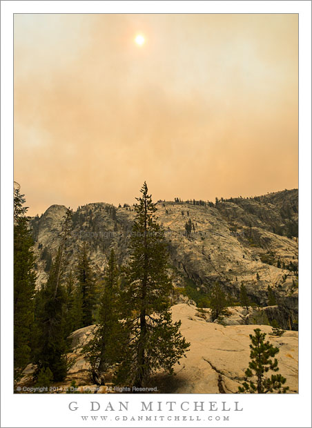
Meadow Fire Smoke Plume. Yosemite National Park, California. September 7, 2014. © Copyright 2014 G Dan Mitchell – all rights reserved.

Thick smoke from the September 2014 Yosemite National Park Meadow Fire drifts over the Grand Canyon of the Tuolumne, blotting out the afternoon sun.

Today’s “Morning Musing” post will take the form of a second “photo of the day,” but with a bit of back-story about what you are seeing.

Last weekend a wildfire suddenly appeared in a popular area of the Yosemite backcountry along the Merced River drainage above Yosemite Valley, roughly between Half Dome, Clouds Rest, and Mount Starr King. I was not in the area of the fire, but further north in a different backcountry area, where our group of photographers had been camped for several days on a high ridge area. On this morning we did see a small “puff” of smoke coming from over the shoulder of Clouds Rest, but it was no larger than other fires that, as is typical this time of year, were burning in various areas of the backcountry.

Our plan was to pack up camp and follow a more-or-less cross-country route into a canyon and on to a new camp that night. We loaded up and set out, and by the time we were half way to our goal the smoke plume has begun to stretch across the sky above our position, thought it was still quite diluted. However, very soon the winds whipped up to a surprising degree and the smoke suddenly became a lot thicker and began to blot out the sun and drop ash on us. By this time we were in a valley and could no longer see the location of the fire, but it was plainly apparent that this fire was roaring and likely to become a very serious matter.

This photograph has not been color corrected at all. This is, in fact, what the atmosphere in and above the canyon looked like! Fortuitously, later that evening as we sat around in camp, we saw a flash in the sky and heard thunder… and before long light rains arrived and continued into the next afternoon.

G Dan Mitchell is a California photographer and visual opportunist whose subjects include the Pacific coast, redwood forests, central California oak/grasslands, the Sierra Nevada, California deserts, urban landscapes, night photography, and more.
Blog | About | Flickr | Twitter | FacebookGoogle+ | 500px.com | LinkedIn | Email

Text, photographs, and other media are © Copyright G Dan Mitchell (or others when indicated) and are not in the public domain and may not be used on websites, blogs, or in other media without advance permission from G Dan Mitchell.

Burned Forest, Twisting Branches

Burned Forest, Twisting Branches

Burned Forest, Twisting Branches. Yosemite Valley, California. March 1, 2014. © Copyright 2014 G Dan Mitchell – all rights reserved.

Bare, twisted branches in burned forest, Yosemite National Park

For a number of years, Yosemite National Park has allowed naturally set fires to more or less burn themselves out under supervision, and management fires are set regularly in areas including Yosemite Valley. For many of us there is a natural negative response to this, at least initially, since we were brought up on a stead Smoky Bear diet of “fire is bad!” It turns out that not all fires are bad. In fact, the healthy forests depend on fire – to clear out underbrush and reduce the fuel load and even to prompt the renewal of plant life. Ironically, there is some thought that one reason for the very big and very destructive fires that have occurred more recently is that fires have been suppressed for so long that too much fuel has built up in the forest, allowing fires that might otherwise be “healthy” to become firestorms that destroy even mature trees.

The evidence of fire is found in many areas of the park, including Yosemite Valley. If you visit late in the season you might find a managed fire underway, closing off sections of the forest and spreading smoke. (While I worry about the health effects of the smoke, I have learned to use it photographically but finding ways to use the haze in my images.) For some time I have worked to find ways to photograph the burned areas. They can have a kind of stark beauty in the right light and when looked at in just the right ways. I had stopped in a more traditional meadow, full of dormant winter grasses and leafless winter trees, when I looked behind myself to see on of the managed burn areas, and these curving and twisting bare limbs against a background of scorched trunks.

G Dan Mitchell is a California photographer and visual opportunist whose subjects include the Pacific coast, redwood forests, central California oak/grasslands, the Sierra Nevada, California deserts, urban landscapes, night photography, and more.
Blog | About | Flickr | Twitter | FacebookGoogle+ | 500px.com | LinkedIn | Email

Text, photographs, and other media are © Copyright G Dan Mitchell (or others when indicated) and are not in the public domain and may not be used on websites, blogs, or in other media without advance permission from G Dan Mitchell.

Rim Fire Burn Zone, Morning

Rim Fire Burn Zone, Morning

Rim Fire Burn Zone, Morning. Near Yosemite National Park, California. October 30, 2013. © Copyright 2013 G Dan Mitchell – all rights reserved.

An area near “Rim of the World” recently burned by the Rim Fire

Late this past summer one of the worst wildfires in the Sierra burned extensive areas near and within the northwest “corner” of Yosemite National Park. The “Rim Fire,” as it has come to be known (since it started near the “Rim of the World” overlook) came at a time of very bad conditions – in hot and dry weather, late in the season, and at the end of a second drought year in California. The first spread very quickly, and it took tremendous efforts to contain it – and full suppression took many, many weeks.

Since the fire burned in areas that I know very well from decades of travel through this part of the Sierra, I was anxious to see the extent of the damage. At first I thought I might get a chance in early September, when I traveled back and forth to the eastern Sierra to photograph fall colors. However, weather interfered – snow closed Tioga Pass Road and I ended up taking different routes across the range. Finally, at the very end of October, on a drive to Yosemite Valley I passed this way early in the morning. Overall, from what little I could observe, several things seem clear: the fire burned a very large area, some sections were very badly damaged and it will be a long time before trees grow there again, other sections were only lightly burned and a few were skipped over. This view, from the “Rim of the World” overlook, rises from the close charred hills above the Tuolumne River Canyon, across more distant ridges, and culminates at far peaks with a light dusting of early season snow. All of the conditions I described above are visible here – serious destruction in the foreground, a bit further in there are some trees that were burned by not killed, and far beyond there is forest that appears to have not been burned.

G Dan Mitchell is a California photographer and visual opportunist whose subjects include the Pacific coast, redwood forests, central California oak/grasslands, the Sierra Nevada, California deserts, urban landscapes, night photography, and more.
Blog | About | Flickr | Twitter | FacebookGoogle+ | 500px.com | LinkedIn | Email

Text, photographs, and other media are © Copyright G Dan Mitchell (or others when indicated) and are not in the public domain and may not be used on websites, blogs, or in other media without advance permission from G Dan Mitchell.

Rim Fire Zone, Morning

Rim Fire Zone, Morning

Rim Fire Zone, Morning. Rim of the World, California. October 30, 2013. © Copyright 2013 G Dan Mitchell – all rights reserved.

Hazy morning light filters across the burned hillsides in the area of the Rim Fire, California

In photographic terms this is perhaps not the most spectacular photograph, and the location is not quite a scenic icon – though it is a place that many stop and take a look on their way to Yosemite, the “Rim of the World” overlook along highway 120 between Groveland and the northern park entrance. However, this view is loaded with implications and connected to many stories.

Late this past summer, the state of California was tremendously dry after a second drought season. It wasn’t a question of whether there would be big wildfires, but more of where, when, and how many. Perhaps the biggest one of all started very near the Rim of the World overlook, and in the hot and dry conditions it quickly – some might say explosively – spread to the north, east, and south. While many think of it as “the Yosemite fire” – and it did burn a lot of terrain inside the park – it really was more of a “Yosemite area” fire. Because of the conditions – the long-term conditions of drought and the immediate conditions of heat and wind – the fire apparently did very serious damage to the forests in the are.

Shortly after the fire was contained, I thought that I might drive through the park on Tioga Pass Road to get to and from the eastern Sierra in early October. In fact, the roads had opened up again by that time, but snow closed Tioga Pass on my trip to the west and we ended up coming back over Sonora Pass. So the post-fire conditions of this area, which is very familiar to me after years of visits, were still an unknown when I drove to The Valley on October 30 for a few days of autumn photography. Passing into the first fringes of the burned areas along highway 120 things didn’t look all that different than they do after any wildfire – some areas badly burned, some singed, and others that mostly escaped the fire. I decided to stop at the Rim of the World overlook, which was pretty much the only place where stopping was allowed, and get out and take a look. I was floored by the scale of the fire. It had come from behind my position, burned down and across the deep canyon of the Tuolumne River, up the canyon walls on the far side, and then across a vast series of receding ridges. Some smoke and haze still seemed to be coming from the area, and early morning light glanced across the ridges, with their dead trees. In the far distance there is a low peak with a bit of early season snow.

I have seen quite a few fires in the park over the past few decades. One not far from here destroyed a large area of forest a few decades ago – and on this trip, ironically, I was noting that new evergreen trees are finally taking hold there. Later several very bad fires blew up from near Foresta, doing terrible damage to the section of Crane Flat Road descending towards The Valley. There have been others. In most of these cases – though I wondered in the case of the most recent Foresta fire, too – it seemed that I could watch the forest recover and return to something resembling what I remember. However, given the intensity and scale of this fire, I wonder if I’ll have that opportunity where the Rim Fire burned?

To end on a cheerier note, a couple of other observations. Even near badly burned areas, I did see sections where this fire only burned some of the vegetation and a few that seemed to have been completely spared. And when I got to a spot inside the park along highway 120 where I often stop to photography dogwood trees in the spring and fall, a spot that seemed like it might have been within the burn zone on the maps, I found my little spot completely intact, with the dogwoods turning to fall colors.

G Dan Mitchell is a California photographer and visual opportunist whose subjects include the Pacific coast, redwood forests, central California oak/grasslands, the Sierra Nevada, California deserts, urban landscapes, night photography, and more.
Blog | About | Flickr | Twitter | FacebookGoogle+ | 500px.com | LinkedIn | Email

Text, photographs, and other media are © Copyright G Dan Mitchell (or others when indicated) and are not in the public domain and may not be used on websites, blogs, or in other media without advance permission from G Dan Mitchell.