Tag Archives: highway

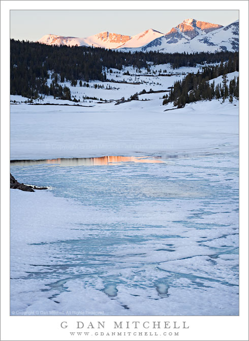
Melting Ice and Sunrise Reflection, Tioga Lake

Melting Ice and Sunrise Reflection, Tioga Lake

Melting Ice and Sunrise Reflection, Tioga Lake. Tioga Pass, California. June 19, 2011. © Copyright G Dan Mitchell – all rights reserved.

Dawn light on the peaks of Kuna Crest is reflected in a meltwater channel in the frozen surface of Tioga Lake at Tioga Pass.

On the weekend that Tioga Pass opened this year, I spent the “opening day” photographing along highway 120 in the park. That night I stayed in Aspen Camp in Lee Vining Canyon, a standby for me at almost all times of year when I photograph in the area and Tuolumne Meadows campground is not open. (That NPS campground typically opens a few weeks after the pass opens and then closes in late September.) The next morning I was up fairly early, planning to photograph more or less in the Tenaya Lake area a bit after sunrise. I drove up toward the pass and soon came to Tioga Lake, which lies next to the road just below the pass.

I had noticed the striking veined patterns formed by the melting ice the previous day but had not photographed them. When I saw them in the morning I spontaneously decided to stop and see what I could do with the subject, especially since it looked like the ice was starting to pick up a bit of color from the pre-dawn light. I quickly got out and set up and found a way to line up the melted channel in the icy surface with the peaks of the distant Kuna Crest inside the park. As the light began to strike this ridge its color reflected on the frozen lake and I made a few photographs before moving on.

G Dan Mitchell Photography | Flickr | Twitter (follow me) | Facebook (“Like” my page) | LinkedIn | Email
Text, photographs, and other media are © Copyright G Dan Mitchell (or others when indicated) and are not in the public domain and may not be used on websites, blogs, or in other media without advance permission from G Dan Mitchell.

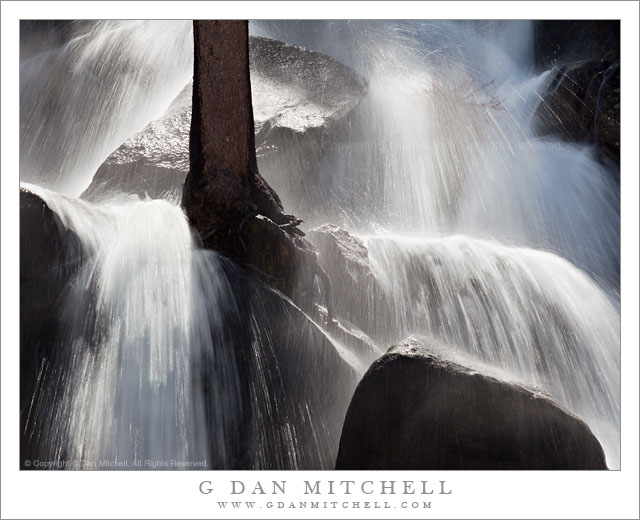
Impossible Tree Falls

Impossible Tree Falls

Impossible Tree Falls. Yosemite National Park, California. June 19, 2011. © Copyright G Dan Mitchell – all rights reserved.

“Impossible Tree Falls” in full early season flow, fed by the runoff from a very heavy snowpack, Yosemite National Park.

I don’t know if this is really called Impossible Tree Falls, but I like the name and I’m going with it. My guess is that the reason for the name might be two-fold. First, the tree does grow right in the middle of this roadside water fall. It must be an interesting few weeks each spring when this tree wakes up to find itself in the middle of a raging water fall, since the rest of the year things are much calmer. Second, the trees seems to grow on nothing but bare rock. It is hard to see in this mist-covered and back-lit image, but it looks like the tree is rooted in solid rock.

For a person who likes to occasionally think of himself as something of a back-country photographer, it is almost embarrassing to admit that this waterfall is right next to Tioga Pass Road. I’ll be honest – I parked my car in a pull-out on the opposite side of the roadway and probably never moved more than 10 yards from there. To add insult to injury, at a couple of points I had to stop shooting while passing recreational vehicles interfered with the view! ;-)

But none of that makes the tumultuous little waterfall any less impressive. It appears above the road, where it seems to come out of a flatter forest area, and then it abruptly tumbles down a very steep rocky incline, twisting and turning around boulders – and one solitary tree.

G Dan Mitchell Photography | Flickr | Twitter (follow me) | Facebook (“Like” my page) | LinkedIn | Email
Text, photographs, and other media are © Copyright G Dan Mitchell (or others when indicated) and are not in the public domain and may not be used on websites, blogs, or in other media without advance permission from G Dan Mitchell.

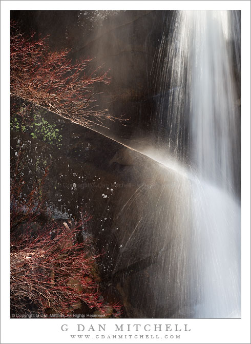
Spring Cascade, Tioga Pass Road

Spring Cascade, Tioga Pass Road

Spring Cascade, Tioga Pass Road. Yosemite National Park, California. June 18, 2011. © Copyright G Dan Mitchell – all rights reserved.

A seasonal stream cascades over a granite ledge along Tioga Pass Road, Yosemite National Park.

This small cascade is one of hundreds seen along Tioga Pass Road on June 18 this year, the day the park service opened the road for the season. The opening date was later than usual due to the heavy snowpack, and there was water everywhere as the snow melt accelerated in the late spring weather. It was almost embarrassingly easy to find and photograph these subjects – this one was right next to the roadway.

This is part of a larger cascade, out of view to the right, that flows off the top of a granite area and drops quickly across granite cliffs. Here the water strikes a slanting ledge and bits of spray explode almost like Fourth of July fireworks. Obviously, the somewhat unusually long shutter speed was selected with this effect in mind. The reddish plants to the left, just beginning to come back to life after the long winter, hint at the early date in the season.

G Dan Mitchell Photography | Flickr | Twitter (follow me) | Facebook (“Like” my page) | LinkedIn | Email
Text, photographs, and other media are © Copyright G Dan Mitchell (or others when indicated) and are not in the public domain and may not be used on websites, blogs, or in other media without advance permission from G Dan Mitchell.

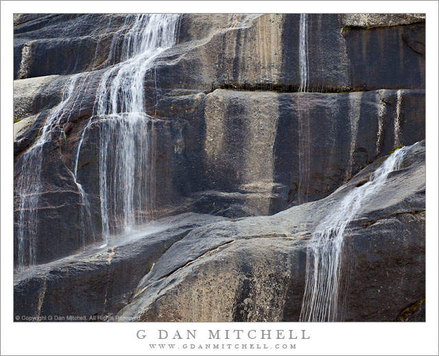
Spring Cascade, Polly Dome

Spring Cascade, Polly Dome

Spring Cascade, Polly Dome. Yosemite National Park, California. June 18, 2011. © Copyright G Dan Mitchell – all rights reserved.

A seasonal spring cascade falls across the granite face of Polly Dome, Yosemite National Park.

I know that the chance to see the high country in winter-like conditions is part of what draws people to the opening of Tioga Pass Road, especially after a heavy snowfall season like this one. But for me the water is at least as much of a draw. The high country comes alive in ways that are not seen during the rest of the year. Because of the long and warmer days, the rate of snow melt accelerates, and when the snowpack is as deep as it is this year, that sets loose an amazing amount of meltwater.

I find full-flowing creeks in places where I didn’t even realize that water flowed. Creeks become raging torrents that threaten to jump their banks. In many places they do rise high enough to flood large expanses of meadow. Seasonal water falls and cascades appear almost everywhere you look.

I spotted this slender cascade high on the granite slopes of Polly Dome, above Tenaya Lake. My first idea was to make a photograph in which a longer stretch of the fall would appear, dropping perhaps several hundred feet. But as often happens, the more I worked this scene the more I wanted to eliminate extraneous material – and I ended up shooting at 400mm to edit out as much of the surround as I could.

G Dan Mitchell Photography | Flickr | Twitter (follow me) | Facebook (“Like” my page) | LinkedIn | Email
Text, photographs, and other media are © Copyright G Dan Mitchell (or others when indicated) and are not in the public domain and may not be used on websites, blogs, or in other media without advance permission from G Dan Mitchell.