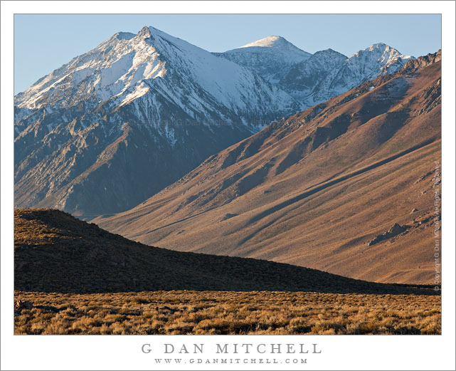
McGee Canyon and Mount Morgan. Owens Valley, California. October 10, 2010. © Copyright G Dan Mitchell – all rights reserved.
Snow crested Mount Morgan rises above McGee Canyon and the sagebrush-covered hills of Owens Valley in the eastern Sierra Nevada.
I’ve been traveling to the Sierra for many years. My first recollection of the range is a faint mental image of a shoreline park at Lake Tahoe when my family moved to California – I was four years old. My next memory is of staying at a small motel in El Portal next to the high water of the Merced River back in the days before the current mega-hotels were erected. One thing that all of my early Sierra experiences had in common is that I always approached the range from the west since I lived (and still live) in the San Francisco Bay Area. For the person whose orientation to the range is from the west, the Sierras are a range that begins almost imperceptibly in the Central Valley. Although you can see distant peaks from the Valley on clear days, it is hard to say where the range begins. As you head east you encounter some very small and rounded hills which gradually get larger. Eventually you are going up more than up and down as you travel through oak and grass lands. At some point the road rises into forest, but the mountain tops are mostly rounded and forest covered. Keep going and a few rocky prominences begin to appear along the ridges and some distant granite peaks become visible. Only after a lot of driving do you find yourself in the higher reaches of the range, and this only in the few areas where roads cross from west to east. In most places you cannot even see the summit of the range close up from the west without walking a long ways.
It was only many years later that I first went over the summit of the range and saw it from the east side. The Sierra is (are?) completely different when approached this way. Instead of a long, gradual, and relatively gentle rise to high valleys and forests and meadows, the eastern escarpment of the Sierra rises abruptly – one might say violently – and directly, in most places, from the high desert sagebrush country of Owens Valley and similar places. This wall of peaks seems almost inaccessible, and I imagine that many people who only drive past on highway 395 must regard it that way.
This photograph was made from a spot just a mile or two east of highway 395, out an a gravel road that I know. I have photographed this shadowed foreground ridge and the peaks beyond in the past, so I had a fairly good idea of what I would find at this location before I made the photograph on an early October morning when fall storms had dusted the highest peaks with snow. I used a somewhat long lens and tight framing to emphasize the rise from the foreground desert to the very high peaks beyond.
This photograph is not in the public domain and may not be used on websites, blogs, or in other media without advance permission from G Dan Mitchell.
G Dan Mitchell Photography
Flickr | Twitter | Facebook Fan Page | Facebook | Friendfeed | Email

