Category Archives: Photographs: Northern California

Photographs from Northern California

Trees, Bluffs, Whalers Cove

Trees, Bluffs, Whalers Cove
The view across Whalers cove toward tree-covered coastal bluffs and hills

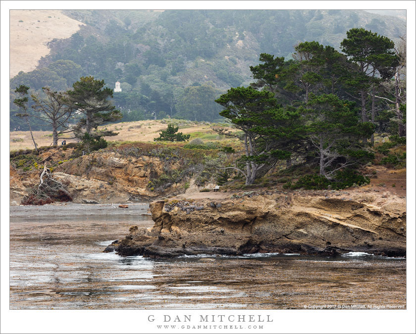
Trees, Bluffs, Whalers Cove. Point Lobos State Reserve, California. July 14, 2017. © Copyright 2017 G Dan Mitchell – all rights reserved.

The view across Whalers cove toward tree-covered coastal bluffs and hills

Point Lobos is the small but beautiful (and often quite over-crowded) state “reserve” located just below Carmel, California at the base of the Monterey Peninsula. I’ve gone there for decades, beginning when I was a child, and I continue to visit, explore, and photograph. These days I’m more likely to go during off-season times, or at least on odd days and at odd hours during the peak tourist season. I made this photograph on a weekday morning, before the tourist traffic built up and on a day when foggy conditions may have discouraged some visitors.

The photograph looks across Whalers Cove, a sheltered inlet along the northern edge of the park which opens toward the shallow bay around the outlet of the Carmel River. Beyond the rocky bluffs immediately above the smooth, kelp-filled waters of the bay forested coastal hills rise. The building is a monastery that gives a nearby beach its name.


G Dan Mitchell is a California photographer and visual opportunist. His book, “California’s Fall Color: A Photographer’s Guide to Autumn in the Sierra” is available from Heyday Books and Amazon.
Blog | About | Flickr | Twitter | FacebookGoogle+ | LinkedIn | Email


All media © Copyright G Dan Mitchell and others as indicated. Any use requires advance permission from G Dan Mitchell.

Pier, Low Tide

Pier, Low Tide
A pier extends across tidal flats at the edge of Tomales Bay, Inverness, California

Pier, Low Tide. Inverness, California. July 23, 2017. © Copyright 2017 G Dan Mitchell – all rights reserved.

A pier extends across tidal flats at the edge of Tomales Bay, Inverness, California

In late July I took a day to visit Point Reyes. My main goal was a long hike over the barren bluffs above Drakes Estero, with my plan being to follow a route all the way to the coast at Drakes Bay, hopefully arriving at just about the time the fog cleared. It was a wonderful hike, with some clearing early on, but ultimately it never did clear at the coast. On a day when merely a few miles inland the temperatures rose into the 90 degree range, here in the fog and wind it never got out of the fifties, and it was almost like enjoying a winter day in July.

Before I began my hike I drove along the shore of long, narrow Tomales Bay, where the road mostly travels right along the shoreline, often only feet from the water. This bay is very sheltered, with a narrow entrance and then a long distance from there to its inner reaches. At the upper end the tides regularly turn the bay into a mudflat. I always am on the lookout for photographs as I drive this route, and as I passed this spot I caught a glimpse of the stark backlight and the brilliant reflections on the mudflat — so I turned around and headed back to make a few pictures of this pier and the building out over the way.


G Dan Mitchell is a California photographer and visual opportunist. His book, “California’s Fall Color: A Photographer’s Guide to Autumn in the Sierra” is available from Heyday Books and Amazon.
Blog | About | Flickr | Twitter | FacebookGoogle+ | LinkedIn | Email


All media © Copyright G Dan Mitchell and others as indicated. Any use requires advance permission from G Dan Mitchell.

Low Tide, Fog, Drakes Estero

Low Tide, Fog, Drakes Estero
Thinning fog above Drakes Estero at low tide

Low Tide, Fog, Drakes Estero. Point Reyes National Seashore, California. July 23, 2017. © Copyright 2017 G Dan Mitchell – all rights reserved.

Thinning fog above Drakes Estero at low tide

I spend a mid-July day hiking — at least once I had completed my obligatory bakery stop at Point Reyes Station — a route at Point Reyes National Seashore that I’ve had my eyes on for some time. It is a trail that starts in the upper recesses of Drakes Estero and, if you turn at the right junctions, finally goes all the way to headlands above Drakes Bay. I had, in fact, started this hike at least once in the past, but always a bit spontaneously and too late in the day, and each time I had turned back before completing it. This time I planned more carefully, and I was on the trail in plenty of time to complete the round trip.

This is a spare landscape, mostly without the vertical scale of places like the Sierra or even of the Big Sur coastline. Bare bluffs run along the peninsula that runs out toward the actual “point,” and the view extends more in the horizontal than the vertical direction. But what it lacks in vertical relief, this landscape can make up for as a canvas on which effects of atmosphere and light may play. My plan was to begin my hike at about the time the morning fog broke up, and to then follow the fog/sun line as in moved toward the coast. I was not entirely successful (it never did clear at the coast) but I timed it just about right for the start of the walk. This photograph comes from that early section of the route, when the clear sky above the dissipating clouds reflected its blue color onto the waters of the estero.


G Dan Mitchell is a California photographer and visual opportunist. His book, “California’s Fall Color: A Photographer’s Guide to Autumn in the Sierra” is available from Heyday Books and Amazon.
Blog | About | Flickr | Twitter | FacebookGoogle+ | LinkedIn | Email


All media © Copyright G Dan Mitchell and others as indicated. Any use requires advance permission from G Dan Mitchell.

Tidal Flat Reflections

Tidal Flat Reflections
Blue sky reflected in channels on tide flats, Point Reyes National Seashore

Tidal Flat Reflections. Point Reyes National Seashore, California. July 23, 2017. © Copyright 2017 G Dan Mitchell – all rights reserved.

Blue sky reflected in channels on tide flats, Point Reyes National Seashore

In late July I spent a day at Point Reyes National Seashore, a location that is probably just within a reasonable one-day out-and-back drive for me. (And, yes, on occasion I indulge in completely unreasonable drives to photograph certain special subjects, but that’s a story for a different post.) From looking at weather forecasts, I was hopeful that I would arrive early enough to grab a fresh pastry at Point Reyes Station (success!), make it out to the Seashore before the fog cleared (success!), and then photograph as it cleared away (less success!). I never did break completely out of the fog, and the final destination of my daylong hike was pretty thoroughly socked in.

But along the way there was some interesting light, combined with some fortunate timing. My hike took me along Drakes Estero, the large, shallow estuary that extends inland from the beaches surrounding Drakes Bay. I had not checked the tides before going, but it turned out that I arrived at a rather low tide, and the water had retreated far enough to leave the mudflats high and dry, broken only by twisting channels where a bit of water remained. The fog directly overhead darkened the mud flats, but the water reflected the blue sky from an area of clearing further in the distance. Once again, it was good fortune that made a photograph possible — these abstract blue patterns could only occur at low tide, with fog overhead, and with blue sky at the fog/clear boundary nearby.


G Dan Mitchell is a California photographer and visual opportunist. His book, “California’s Fall Color: A Photographer’s Guide to Autumn in the Sierra” is available from Heyday Books and Amazon.
Blog | About | Flickr | Twitter | FacebookGoogle+ | LinkedIn | Email


All media © Copyright G Dan Mitchell and others as indicated. Any use requires advance permission from G Dan Mitchell.