Tag Archives: desert

Southwest Sky

Southwest Sky
Morning clouds above the landscape of Capitol Reef National Park

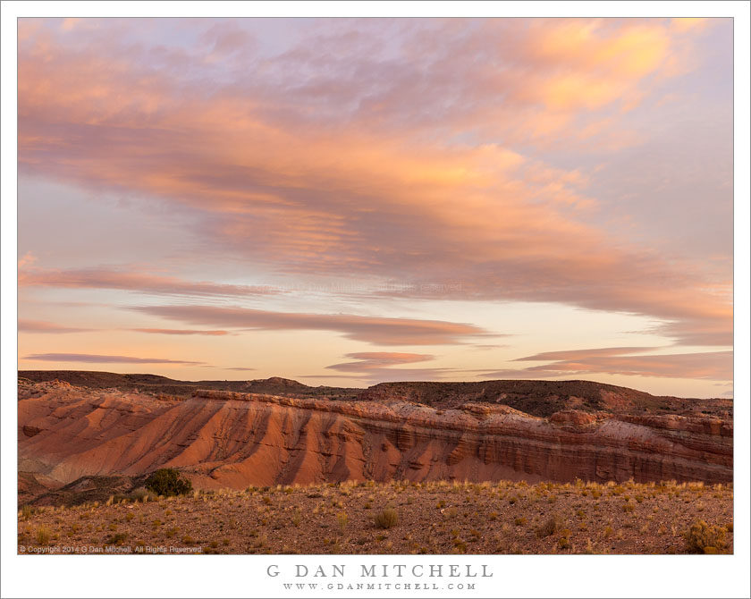
Southwest Sky. Capitol Reef National Park, Utah. October 22, 2014. © Copyright 2014 G Dan Mitchell – all rights reserved.

Morning clouds above the landscape of Capitol Reef National Park

On this October morning we were up early, but not quite early enough — though it turned out fine in the end. We awoke before sunrise, with a plan to head down along the east side of Capitol Reef National Park along the Waterpocket Fold. We hoped to be a good distance down this route when the sun rose, but we got up later than expected. We were far from our goal when the dawn arrived.

Our location was, in some ways, not the spectacular sort of place that we had envisioned for sunrise. However, there were absolutely beautiful clouds to our north, and the dawn light’s color could probably make any subject look good. So our immediate goal became quickly finding any place that looked like it might have photographic potential — and to find it NOW! Within a few minutes we found a short side road, drove a short distance to a hilltop, parked, and piled out of the vehicle, more or less already in the act of setting up tripods and cameras. We had only a few moments on special light on the clouds before it began to fade to daytime light.


G Dan Mitchell is a California photographer and visual opportunist. His book, “California’s Fall Color: A Photographer’s Guide to Autumn in the Sierra” is available from Heyday Books and Amazon.
Blog | About | Flickr | Twitter | FacebookGoogle+ | LinkedIn | Email


All media © Copyright G Dan Mitchell and others as indicated. Any use requires advance permission from G Dan Mitchell.

Sandstone Canyon Walls

Sandstone Canyon Walls
Detail of a fractured sandstone canyon walls at Capitol Reef National Park.

Sandstone Canyon Walls. Capitol Reef National Park, Utah. October 20, 2014. © Copyright 2014 G Dan Mitchell – all rights reserved.

Detail of a fractured sandstone cliff in a canyon at Capitol Reef National Park.

Over several years and several visits I began to understand Capitol Reef National Park a bit more. (Though it is a big and varied place, and true knowledge of the place — as is the case with any such landscape — comes from longer experience than I yet have.) Understanding comes partly from experiencing a wider range of the park’s geography than that in the most conveniently located places. Visiting during different parts of the year and in varied conditions helps — a sunny spring morning is very different from a freezing late October morning. Finding a few personal spots that feel like familiar friends is part of the process.

The sandstone-walled canyons are all over this part of the Southwest. I distinctly recall the first one I visited, walking into it in the morning, wading up canyon in the shallow stream, winding through its twists and turns as the canyon deepened. More visits taught me that each canyon has is own personality — yet some general features are shared by most of them. Unlike most of my Sierra Nevada world, where one often feels open to the entire sky, in the canyons the world shrinks to what you can see between two twists in the course of the stream that created the canyon. Views of the sky are extremely limited, and your focus soon turns almost exclusively to things that are nearby. There is little wind and usually the quiet is broken only by the sound of water, perhaps some birds, and your own passage. The light bounces among red rock walls and diffuses as it gently arrives from far above.


G Dan Mitchell is a California photographer and visual opportunist. His book, “California’s Fall Color: A Photographer’s Guide to Autumn in the Sierra” is available from Heyday Books and Amazon.
Blog | About | Flickr | Twitter | FacebookGoogle+ | LinkedIn | Email


All media © Copyright G Dan Mitchell and others as indicated. Any use requires advance permission from G Dan Mitchell.

Mono Basin

Mono Basin
Desert hills, Mono Lake, Paoha Island, and the Mono Basin in morning light

Mono Basin. East of the Sierra Nevada, California. July 15, 2016. © Copyright 2016 G Dan Mitchell – all rights reserved.

Desert hills, Mono Lake, Paoha Island, and the Mono Basin in morning light

When people think of Mono Lake they often seen to think first of the unusual tufa tower formations found along portions of its shoreline — and the subject of many photographs from the place. The towers are indeed impressive and unusual, and especially in the right light they can produce an almost other-worldly impression. But there is much more to be seen here.

My strongest associations with the lake do not involve tufa towers. Instead the strongest may simply be an impression of the vast space of the basin holding this giant lake, and the immense expanse of sky above — often pure blue and clear, but at times opaque with haze or broken by thunder clouds. There are sonic associations, and the strongest may be the sound of gulls and other birds, especially on a quiet and windless morning. On the morning when I made this photograph I was not at the “usual places” at dawn, but I passed by just a bit later, when the sun was a bit higher but the light was still spreading mostly sideways across the landscape, producing large and dark shadows.


G Dan Mitchell is a California photographer and visual opportunist. His book, “California’s Fall Color: A Photographer’s Guide to Autumn in the Sierra” is available from Heyday Books and Amazon.
Blog | About | Flickr | Twitter | FacebookGoogle+ | LinkedIn | Email


All media © Copyright G Dan Mitchell and others as indicated. Any use requires advance permission from G Dan Mitchell.

Clearing Dust Storm, Evening

Clearing Dust Storm, Evening
Translucent atmosphere as the sky clears in the wake of a Death Valley dust storm

Clearing Dust Storm, Evening. Death Valley National Park, California. March 30, 2016. © Copyright 2016 G Dan Mitchell – all rights reserved.

Translucent atmosphere as the sky clears in the wake of a Death Valley dust storm

This was the tail end of a massive dust storm that was with us in one form or another for an entire day. Very early in the morning we had seen the precursor conditions when we visited a high ridge in the Panamint range before dawn. At that time there was a kind of haze in the atmosphere that I had come to associate with incipient dust storm conditions. By midday the dust was easily seen rising out of the great valleys on either side of the mountains, and before long tendrils of dust were snaking through the air above our position. Returning to Death Vally itself we encountered a wild scene — thick dust everywhere and extremely high winds. We gave up and shut ourselves indoors for a few hours, and then not long before sunset the wind abated a bit, and I ventured outside.

The dust storm was still raging across the valley, but in our location the winds had dropped considerably. But in the interim a weather system had moved overhead, and now it was raining into the dust storm — something I had not encountered here before. I made my way to an elevated location that was above much of the worst of the dust and from which I had wide views across the lower end of the Valley. From there I could see the Cottonwood Mountains to the west, and as the air cleared slightly the light made its way under the clouds and back-lit the dust still floating in the translucent atmosphere.


G Dan Mitchell is a California photographer and visual opportunist. His book, “California’s Fall Color: A Photographer’s Guide to Autumn in the Sierra” is available from Heyday Books and Amazon.
Blog | About | Flickr | Twitter | FacebookGoogle+ | LinkedIn | Email


All media © Copyright G Dan Mitchell and others as indicated. Any use requires advance permission from G Dan Mitchell.