
Tag Archives: desert

Eroded Ridge and Valley

Eroded Ridge and Valley
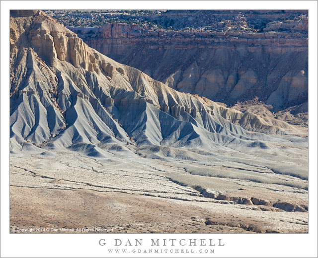
Eroded ridge and valley in the Waterpocket Fold area, Utah

Eroded Ridge and Valley. Capitol Reef National Park, Utah. October 22, 2014. © Copyright 2014 G Dan Mitchell – all rights reserved.

Eroded ridge and valley in the Waterpocket Fold area, Utah

This landscape could hardly be more different from the landscape in yesterday’s photograph. The earlier photograph was of Drake’s Estero, at the Point Reyes National Seashore, made on a day that was almost entirely foggy until a brief interval of filtered sun illuminated the blue waters of the estuary, a bit of green on a peninsula, and distant sky and water. None of those things are found in this photograph.

This landscape from Capitol Reef National Park is austere, arid, and quite rugged. It has a special beauty, but it is not a beauty with soft edges, misty skies, and water. Here the land is laid bare, seeming from a distance to be devoid of plant life. (Once inside this landscape, it turns out to be a bit more alive than it might seem.) Geology and the effects of time are visible in these places with their colored layers of rock, deeply cut valleys, and rugged erosion forms. Here gullies lie below rocky ridges, and two valleys come together in a flat area laced by stream beds.


G Dan Mitchell is a California photographer and visual opportunist. Blog | About | Flickr | Twitter | FacebookGoogle+ | 500px.com | LinkedIn | Email


All media © Copyright G Dan Mitchell and others as indicated. Any use requires advance permission from G Dan Mitchell.

Dust Storm, Desert Mountains

Dust Storm, Desert Mountains
Dust from a desert sand storm fills the air and obscures mountains

Dust Storm, Desert Mountains. Death Valley National Park, California. April 1, 2015. © Copyright 2015 G Dan Mitchell – all rights reserved.

Dust from a desert sand storm fills the air and obscures mountains

You’ll have to look closely to make sense of this one. Made on April 1st, there is a certain sense about this photograph of a minor April Fools joke played at my expense. I had experienced several days of very dusty conditions in Death Valley. On the first day I was way up in the Panamint Mountains at dawn, only to discover that I was still within a cloud of dusty air the extended up to well above 8000′ of elevation. I never did figure out where it was coming from, as the Valley itself certainly wasn’t producing it. That night the winds came to the Valley and blew a decent sand storm through my camp. The next day I figured that I would try to find a way to evade the blowing dust.

I got up very early — as always — and headed out of Death Valley and to the east toward Nevada. I then took a long back road route back into the park. This route took me on back-country gravel roads through the Amargosa Range, eventually dropping down into a deep canyon before heading back to Death Valley. Driving in these mountains and down this canyon, I forgot about the dusty conditions — here there wasn’t more than a bit of hazy atmosphere and the wind didn’t work its way into this canyon either. At the bottom of the canyon the route finally emerged from a narrow canyon and arrived at the top of a huge gravel fan stretching down toward the Valley. And here I saw the extent of the dust and wind, as the entire Valley was full of dust that was well-distributed yet thick enough to almost completely obscure the mountain range on the other side. My day of clear weather came to an abrupt end as I descended into the dust and wind and headed back to my camp.


G Dan Mitchell is a California photographer and visual opportunist. Blog | About | Flickr | Twitter | FacebookGoogle+ | 500px.com | LinkedIn | Email


All media © Copyright G Dan Mitchell and others as indicated. Any use requires advance permission from G Dan Mitchell.
Panamint Range, Reflection

Panamint Range, Reflection
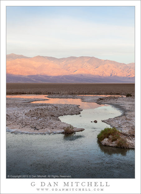
The east face of the Panamint Range is reflected in the surface of a desert pool

Panamint Range, Reflection. Death Valley National Park, California. April 31, 2015. © Copyright 2015 G Dan Mitchell – all rights reserved.

The east face of the Panamint Range is reflected in the surface of a desert pool

This is a photograph of one of those surprising features of Death Valley — water in the middle of a place that is astonishingly arid. This location is one of the lowest, hottest, and driest places in the Valley, and beyond this pool is a terrain that is particularly inhospitable, the famous salt flats. It is not pleasant to venture out there on a hot and sunny day, when not only is the heat oppressive but the light is so intense on the white playa surface that it is almost impossible to look.

I went here quite early one morning, in time for the sunrise light across the Valley on the mountains of the Panamint Range. In many ways this was not a hugely promising morning. I would have preferred some interesting clouds, though the thing high clouds are not completely uninteresting. It might have been nice to have white salt flats, but the playa had apparently gone so long without rain and had experience enough wind that the sometimes-white salt was quite gray. This little pool, at the edge of the Valley and the base of the tall and rugged hills, mirrored the early morning sky and a bit of the dawn color on the mountains.


G Dan Mitchell is a California photographer and visual opportunist whose subjects include the Pacific coast, redwood forests, central California oak/grasslands, the Sierra Nevada, California deserts, urban landscapes, night photography, and more.
Blog | About | Flickr | Twitter | FacebookGoogle+ | 500px.com | LinkedIn | Email

Text, photographs, and other media are © Copyright G Dan Mitchell (or others when indicated) and are not in the public domain and may not be used on websites, blogs, or in other media without advance permission from G Dan Mitchell.
Dunes and Mountains

Dunes and Mountains
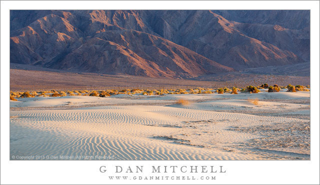
Low dunes and the base of Tucki Mountain in evening light

Dunes and Mountains. Death Valley National Park, California. March 31, 2015. © Copyright 2015 G Dan Mitchell – all rights reserved.

Low dunes and the base of Tucki Mountain in evening light

This is a different interpretation of a photograph that I have previously posted. Here I have simply tried a different crop, one that eliminates some areas of from the top and bottom of the earlier photograph in order to focus more on the horizontal sweep of the shallow dunes and the more distant wash sloping up to the base of gigantic Tucki Mountain, here in nearly the last light of the evening.

I think that when we are in this place, one of the most iconic in Death Valley National Park, our attention is more likely to be drawn to the tallest dunes, which are located more or less behind me at this camera position. But there is much else to see here, ranging from the intimate landscape of ripple sand and small plants to the rugged slopes of Tucki Mountain just to the south, and including the many long views across the huge spaces of the valley. Here I had been mostly photographing an expanse of dunes leading off toward the northeast, when I turned around to see this view of the edge of the sand, with low dunes curving toward the sparse plant life at their edge.


G Dan Mitchell is a California photographer and visual opportunist whose subjects include the Pacific coast, redwood forests, central California oak/grasslands, the Sierra Nevada, California deserts, urban landscapes, night photography, and more.
Blog | About | Flickr | Twitter | FacebookGoogle+ | 500px.com | LinkedIn | Email

Text, photographs, and other media are © Copyright G Dan Mitchell (or others when indicated) and are not in the public domain and may not be used on websites, blogs, or in other media without advance permission from G Dan Mitchell.