Tag Archives: drakes

Estero de Limantour

Estero de Limantour
A foggy day at Estero de Limantour, as viewed from Drakes Head, Point Reyes National Seashore

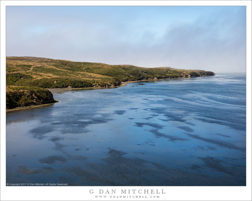
Estero de Limantour. Point Reyes National Seashore, California. July 23, 2017. © Copyright 2017 G Dan Mitchell – all rights reserved.

A foggy day at Estero de Limantour, as viewed from Drakes Head, Point Reyes National Seashore

This post is a bit about this photograph and a bit about the experiences that such photographs are embedded in. The location is a somewhat remote location at Point Reyes National Seashore — the hike out and back runs about 13 miles or so. I have wanted to visit this spot for a number of years, but every time I have started the hike it has been too late in the day to complete the round-trip, or else I was distracted by other photographic opportunities along the way and I did not get all the way to the destination. This time I arrived early enough and got on the trail right away, and I did not stop too much along the way.

What did I find at the end of this long walk? The trail ends dramatically with a slight rise to a high point on a promontory overlooking Estero de Limantour far below, and the expanse of Drakes Bay beyond that. Or so I imagine. When I got there it was very foggy and extremely windy, and at times the water in this photograph was obscured by fog. Because the clouds had been breaking up further inland I decided to wait here in anticipation that the clearing would make it all the way to the coast. After waiting for an hour and a half (!) the fog began to lift and I could start to make out the water beyond the sandy island running along the shoreline. I jumped up and made preparations for the glorious breakup of the clouds… and then the wind picked up, the fog closed in, and it began to drizzle! I made this photograph during a slightly clearer moment. Before I loaded up the pack for the hike back I remembered that great light doesn’t always arrive, that you must be out there a lot if you expect to see it when it happens, if you are out there a lot you will experience lots of “failures,” and that even on a day that might not be optimally photographic there is nothing at all wrong with spending and hour and a half on a windswept bluff engulfed by ocean fog.


G Dan Mitchell is a California photographer and visual opportunist. His book, “California’s Fall Color: A Photographer’s Guide to Autumn in the Sierra” is available from Heyday Books and Amazon.
Blog | About | Flickr | Twitter | FacebookGoogle+ | LinkedIn | Email


All media © Copyright G Dan Mitchell and others as indicated. Any use requires advance permission from G Dan Mitchell.

Low Tide, Drakes Estero

Patterns emerge and reflect the sky at low tide on a foggy morning at Drakes Estero

Low Tide, Drakes Estero. Point Reyes National Seashore, California. July 23, 2017© Copyright 2017 G Dan Mitchell – all rights reserved.

Patterns emerge and reflect the sky at low tide on a foggy morning at Drakes Estero

Although I have been visiting the Point Reyes National Seashore, just north of San Francisco, for quite a few years, it has sometimes been a challenging place for me to photograph. Perhaps it is because, with some exceptions, it generally doesn’t feature the same sorts of iconic and spectacular Pacific coast subjects found in places such as the Big Sir coast. instead there are coastal lowlands with most-treeless bluffs, thick and impenetrable forests further inland, and grand vistas across low-lying landscapes. But given enough time and patience and persistence, I think ti begins to be possible to discover a way of seeing almost any landscape, and I’m starting to understand how to see this place.

I knew it that there would be fog on this visit, and my plan/hope was that I could get there at the right time to place myself along the boundary between sun and fog, where interesting things often happen with the light. I decided to take a rather long hike (about 13 miles roundtrip) to a location that I have long wanted to visit, and I arrived at the trailhead just as the fog was beginning to thin there. After dropping through forest I arrived and crossed one arm of Drakes Estero as the tide was at its low point, revealing mud flats along the shoreline. The trail climbed again and I came around another high headland to see a more expansive view toward the fog over the ocean to the west. The low tide revealed remarkable patterns in the estero, and the shallow water reflected the deep blue sky and the thinning fog clouds.


G Dan Mitchell is a California photographer and visual opportunist. His book, “California’s Fall Color: A Photographer’s Guide to Autumn in the Sierra” is available from Heyday Books and Amazon.
Blog | About | Flickr | Twitter | FacebookGoogle+ | LinkedIn | Email


All media © Copyright G Dan Mitchell and others as indicated. Any use requires advance permission from G Dan Mitchell.

Drake’s Estero

Drake's Estero
Summer sun penetrates clearing fog over Drake’s Estero, Point Reyes National Seashore

Drake’s Estero. Point Reyes National Seashore, California. June 27, 2015. © Copyright 2015 G Dan Mitchell – all rights reserved.

Summer sun penetrates clearing fog over Drake’s Estero, Point Reyes National Seashore

I took my camera for a hike this week. Or at least that’s how it felt. I have to confess that Point Reyes, a place I visit somewhat regularly, has always been a photographic challenge for me. I can’t quite put my finger on why that is. I certainly have good results with seascape photographs from other areas along the California coast. As I hiked today — an eight mile round trip to the entrance to Drake’s Estero* — I pondered this what might explain it. Because the point extends out into the ocean, it is often foggy. This fog is not the mysterious sort that hangs along the ground and partially obscures trees and hills. It tends to be the cold gray fog that hovers a few hundred feed up, simply blocking and flattening the light. Although I’m intrigued by this landscape, much of it can be quite barren. There are forests, but they often consist of slender trees growing closely together, often with dense undergrowth. It is difficult to find the things that attract me to the landscapes of the Sierra and the desert — rugged rocky forms, tall cliffs (there are some of these at Point Reyes), light-filled forests, bare and rocky ground. Oh, and did I mention the wind!?

But I keep going back, frequently returning with only a few photographs. This was one of those days. I very much like the place I hiked — a route that alternates between forest, tramping along the waterline, and traversing high bluffs above the estero. I walked four miles out past the end of the trail, to a place where I could walk along a narrow band at the base of cliffs that front the estero, and across the relatively still water were sandbars with birds. Beyond that the surf broke outside of the entrance to the estero. At this far end of the hike I was completely alone, and I found a rock to sit on and quietly take in this scene before turning around to retrace my steps. The photographic challenges on this walk were primarily the strong winds and the gray light. As I passed along the top of one of the bluffs, the sky cleared enough to produce beautiful, soft light on the water and the far peninsula, providing an opportunity to make my one good photograph of the day.

  • “Drake’s Estero” is, as you probably guessed, an estuary — but here I’m using the word that the park service uses for this feature.

G Dan Mitchell is a California photographer and visual opportunist. Blog | About | Flickr | Twitter | FacebookGoogle+ | 500px.com | LinkedIn | Email


All media © Copyright G Dan Mitchell and others as indicated. Any use requires advance permission from G Dan Mitchell.

Point Reyes and Drakes Bay

Point Reyes and Drakes Bay

Point Reyes and Drakes Bay. Point Reyes National Seashore, California. February, 9, 2013. © Copyright 2013 G Dan Mitchell – all rights reserved.

Drakes Bay and the Point Reyes Peninsula, viewed from near Mount Vision on Inverness Ridge

After photographing very early in the morning along the shores of Tomales Bay near the town of Inverness, I continued along the road to Point Reyes and soon entered the national seashore. There was a possibility that I might try to meet up with a group of people who planned to photograph the herds of tule elk a bit later in the morning, but at this point I had some time to kill before that might occur. I wasn’t quite sure where I was going to shoot, so I was sort of “following my nose” and the light, atmosphere, and other conditions and waiting to see where I might end up. I had a general idea that it might be interesting to go all the way out to the point itself, where the morning light might illuminate some of the cliffs along Drakes Bay that don’t get that sort of light later in the day.

However, long before I got close to that area I passed a turn-off that I had often noticed and wondered about, a road labelled Mount Vision. With one option looking just about as good as any other option, I decided to head up that road to see what I could see. The road climbs quickly, more or less switchbacking up a steep include and up a few valleys before more or less leveling off high up on Inverness Ridge, actually ascending to the top of the ridge in a few spots and providing panoramic views both towards the ocean and back towards Tomales Bay. Although it wasn’t exactly foggy – at least not in the form that is common here much of the year – the atmosphere was obscured and out at the far end of the peninsula the curving end of Point Reyes was a bit hard to see, and there was a distinct blue quality to the haze that didn’t seem like it was going to work especially well for a color photograph. So I started thinking that this scene might work better in black and white. Soon I saw this steep foreground ridge with its tall trees and dark shaded elements and it seemed like its angle and darker tones might set off the lighter and less contrasty elements of the landscape in the distance, from the tree-filled valley in the middle of the frame to the barely visible peninsula near the horizon.

G Dan Mitchell is a California photographer and visual opportunist whose subjects include the Pacific coast, redwood forests, central California oak/grasslands, the Sierra Nevada, California deserts, urban landscapes, night photography, and more.
Blog | About | Flickr | Twitter | FacebookGoogle+ | 500px.com | LinkedIn | Email

Text, photographs, and other media are © Copyright G Dan Mitchell (or others when indicated) and are not in the public domain and may not be used on websites, blogs, or in other media without advance permission from G Dan Mitchell.