Tag Archives: lakes

Clearing Storm, Carson Peak and Grant Lake

Clearning Storm, Carson Peak and Grant Lake

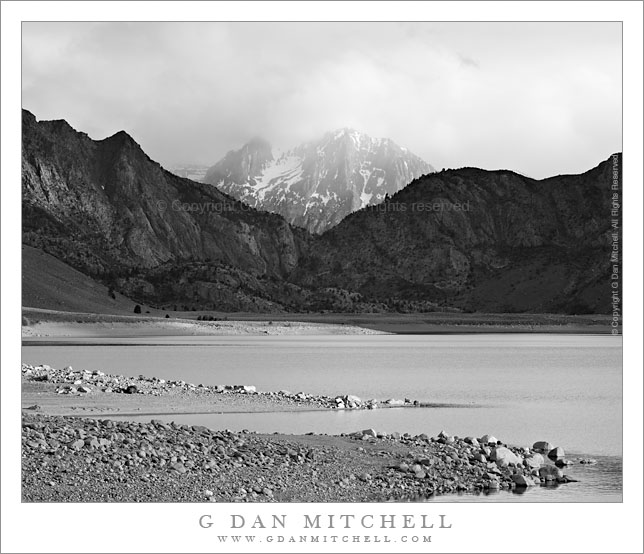
Clearing Storm, Carson Peak and Grant Lake. June Lakes Loop, California. June 7, 2009. © Copyright G Dan Mitchell – all rights reserved.

A late spring storm clears from the summit of Carson Peak above Grant Lake along the June Lakes Loop, California.

I’ll start by saying that I hope I have identified this peak correctly. I did not know its name when I made the photograph, and I think I’ve lined it up with the other geographic features on my map correctly – but if any one has a different ID on this peak please let me know.

I came to Grant Lake (which is actually, and obviously, a reservoir) from the back route, arriving by way of some dirt roads coming in from highway 395. I arrived at the dam and followed the road across, stopping in the middle to make some photographs when I saw this late light on the lake and shoreline with the peak gradually emerging from the remnants of this late-spring storm.

This photograph is not in the public domain. It may not be used on websites, blogs, or in any other media without explicit advance permission from G Dan Mitchell.

keywords: late, spring, storm, clears, clearing, carson, peak, grant, lake, june, lakes, loop, road, reservoir, rock, peninsula, low, water, surface, boulder, sun, light, evening, eastern, sierra, nevada, mountain, range, ridge, shadow, tree, forest, rock, valley, tower, cloud, blue, sky, landscape, travel, scenic, stock

Hitchcock Lakes

High Lakes, Trail Crest
Terrain to the west of Whitney Trail Crest

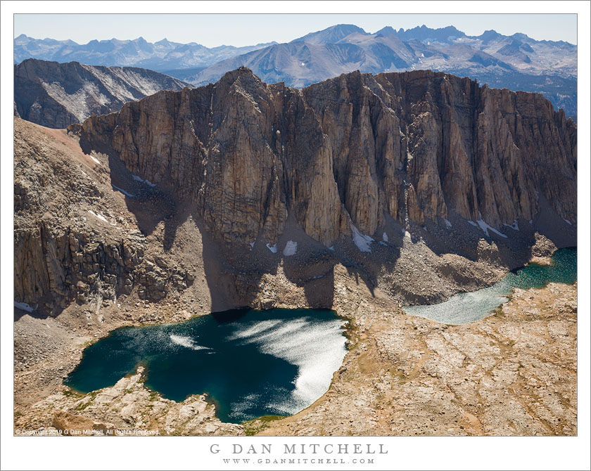
Hitchcock Lakes from the Mt. Whitney Trail. Sequoia National Park, California. August 11, 2008. © Copyright 2008 G Dan Mitchell – all rights reserved.

Hitchcock Lakes seen from the Mt. Whitney Trail.

I climbed Mount Whitney – again – on August 11, 2008 after crossing the Sierra Nevada from west to east on Sequoia National Park’s High Sierra Trail. I’ve been to the summit a couple times in the past. Last year I swore I would not climb this peak again, mainly because there are so many other beautiful things to see in the Sierra and I didn’t feel a strong need to do this again. But my friends proposed a trip that concluded with the Whitney ascent, and I couldn’t say no.

A traditional starting point for ascents from the west is Guitar Lake, a small – and often somewhat crowded – little lake in a truly alpine setting just above timberline. From here the trail ascends the valley containing these lakes, leading to the junction with the trail from the east side just before reaching the ridge, and then a lateral trail traverses out to the summit of Whitney.

It won’t surprise anyone if I say that there are some wonderful panoramas to be seen from almost any point on this climb. One of my favorite is this view back across the valley from which the trail ascended and towards high elevation Hitchcock Lakes and the ridge between them and the Crabtree Basin beyond.

(Oddly, I often find the summit view to be photographically uninspiring, and I usually end up just making some “record” photos there and a perfunctory pano or two.)


G Dan Mitchell is a California photographer and visual opportunist whose subjects include the Pacific coast, redwood forests, central California oak/grasslands, the Sierra Nevada, California deserts, urban landscapes, night photography, and more.
Blog | About | Flickr | Twitter | FacebookGoogle+ | 500px.com | LinkedIn | Email

Text, photographs, and other media are © Copyright G Dan Mitchell (or others when indicated) and are not in the public domain and may not be used on websites, blogs, or in other media without advance permission from G Dan Mitchell.
Young Lakes – Yosemite National Park

I just got an email from someone who will be visiting Yosemite from Europe later this summer, asking about visiting the beautiful Young Lakes area in the Yosemite National Park high country. I posted a copy of my reply in the forum.

Mo’s Cloud

Mo's Cloud
Mo’s Cloud

Mo’s Cloud. Eastern Sierra Nevada, California. May 28, 2005. © Copyright 2014 G Dan Mitchell – all rights reserved.

We spotted this remarkable cloud while camping in the desert near Mammoth during a Memorial Day ski trip. This portion is the west end of a layered cloud that extended for many miles to the left of what is shown here. I think this is probably what is known as the “Sierra Wave,” a cloud band that is formed by air rising over the Sierra crest.

The title “Mo’s Cloud” derives from the fact that Maureen (“Mo”), a friend and one of our group members, reported that she had watched this cloud for hours as she drove up the east side of the Sierra from Southern California.

Although the layered cloud moved little if at all, it was very windy where we were and the local clouds were moving quite quickly. Timing was everything in terms of getting an interesting pattern of light and shadow in the foreground.

G Dan Mitchell is a California photographer and visual opportunist whose subjects include the Pacific coast, redwood forests, central California oak/grasslands, the Sierra Nevada, California deserts, urban landscapes, night photography, and more.
Blog | About | Flickr | Twitter | FacebookGoogle+ | 500px.com | LinkedIn | Email

Text, photographs, and other media are © Copyright G Dan Mitchell (or others when indicated) and are not in the public domain and may not be used on websites, blogs, or in other media without advance permission from G Dan Mitchell.