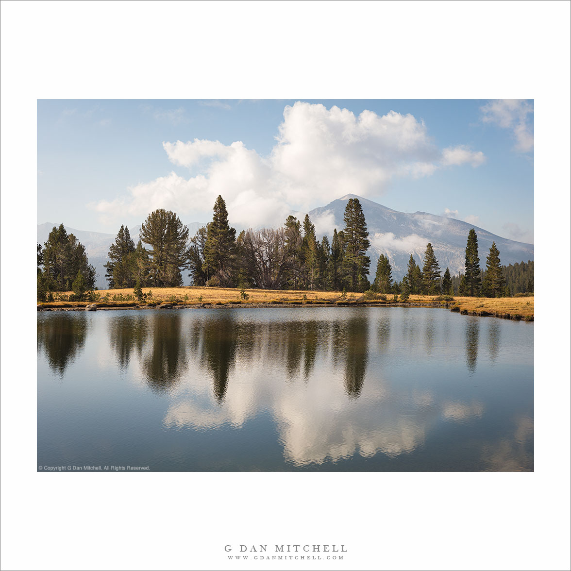
“Sierra Crest Tarn” — Clouds over Mammoth Peak and a Tioga Pass tarn.
Sometimes when I visit the Sierra I cover surprising distances to get from location to location. But I devoted the entirety of my mid-September visit to the Yosemite high country to locations between Tuolumne Meadows and Tioga Pass. I made this photograph from as far east as I went, right at the pass, where small tarns dot a landscape of meadows and small trees.
This can be a green and even lush place early in the season, but by the end of summer the meadows dry out and turn “California golden.” I made the photographer relatively early in the morning, when clouds were just beginning to build above Mammoth Peak and the Kuna Crest.
Leave a comment or question using the form. (If you are reading this on the home page, click the article title to see the full article and the comment form.
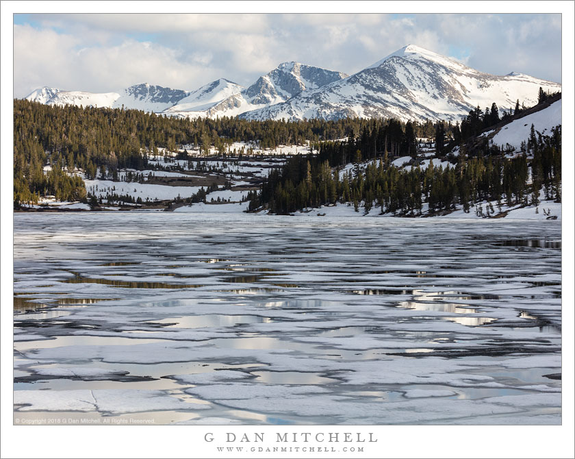
A partially melted lake and snow-covered mountains near the Sierra Nevada crest.
For many of us the annual re-opening of Tioga Pass Road through the Yosemite high country marks the beginning of the “summer” season, even though it often takes place in late spring. (And, “the season” typically extends into autumn, too.) Whenever I can, I try to be there on the day the road opens. For those familiar with the route from more typical summer visits, the conditions can be a real surprise, especially in years of heavy snowfall and late melts. In the big years there is water everywhere — waterfalls flowing, creeks and rivers are filled to (and beyond) their banks, meadows are flooded, and sometimes the creeks flow right across the roadway. Conditions beyond the road can be quite difficult, approaching impossible at times. (I recall one very early season hike to Parker Pass, when creek crossings were surprisingly challenging and some high elevation areas that are dry in summer were too wet to walk through.)
I decided not to go on the first open day this year, mostly due to weather issues, instead postponing my visit for a couple of days. I did go, and it turned into one of my epic one-day-up-and-back trips. I was on the road shortly after 4:00 AM, went as far as Panum Crater (which I climbed) near Mono Lake, and didn’t get back home until well after midnight. In some ways, this isn’t the ideal time for photography — that can be more interesting later on when the meadows have turned green. Honestly, it is more about kicking off the new season. Late in the day, I headed back up from Lee Vining to cross Tioga Pass and stopped briefly to photograph this familiar lake just the pass, with its remarkable pattern of melting ice and the distance peaks of Kuna Crest still fully covered in snow.
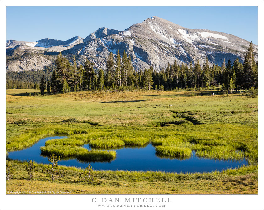
Mammoth Peak and Kuna Crest tower above the Dana Fork of the Tuolumne River
I have photographed this mountain a number of times. It is a weakness, but I know that the weakness is shared by quite a few other photographers, too! If you approach Tioga Pass from the east, as you pass Tioga Lake and ascend the last stretch toward the summit of the pass, this beautiful mountain lies directly ahead, straight across the pass.
It is often photographed from the pass or very close to it, and for good reason. There are several lovely tarns at the pass, and it is quite possible to include them and even the reflection of the peak in their waters. However, I wandered off in a different direction, a bit below the pass, spending a couple of hours exploring the upper reaches of Dana Meadows, which line the Dana Fork of the Tuolumne River as it begins its journey to the confluence with the Lyell Fork and points to the west.
Rain from an afternoon thunderstorm begins to fall above Barney Lake, in the eastern Sierra Nevada near Mammoth Lakes, California.
This is yet another older photograph that I found again while reviewing nearly a decade of raw files recently. I actually have previously posted another similar photograph of this scene in the past, but I think this one is also effective and is somewhat different.
I came to this lake when I had to leave a group of friends with whom I was about four days into a 14-day backpacking trip in the central Sierra back in 2005. On day four I woke up feeling less that great and thought I might be coming down with some sort of “bug” that I didn’t want to deal with in the back-country, partly because we were about to enter a section of trail with no quick and easy way out, and also because I didn’t want to take a chance on slowing down or halting the rest of my party. So I bailed out on the morning of day five. The rest of the gang went south on the John Muir Trail while I backtracked to the north and exited over Duck Pass.
I recall the day fairly well – perhaps because I travelled the trail twice in two days! It was easy hiking back along the JMT to the turnoff to the pass, where I paused to enjoy the view of Duck Lake. As I began the ascent to the pass above the lake, thunderstorms quickly developed, and I recall being surprised when the rain started much more quickly and much sooner than I had predicted. I believe I had to duck (no pun intended) beneath a nearby tree and quickly take out rain gear and pack cover before moving on in the rain. After I crossed the pass and started the descent towards Mammoth Lakes, the storm moved elsewhere and rays of light broke over Barney Lake below the pass where I paused to make a few photographs of this light against the backdrop of more distant peaks and falling rain.
Photographer and visual opportunist. Daily photos since 2005, plus articles, reviews, news, and ideas.
Manage Consent
To provide the best experiences, we use technologies like cookies to store and/or access device information. Consenting to these technologies will allow us to process data such as browsing behavior or unique IDs on this site. Not consenting or withdrawing consent, may adversely affect certain features and functions.
Functional
Always active
The technical storage or access is strictly necessary for the legitimate purpose of enabling the use of a specific service explicitly requested by the subscriber or user, or for the sole purpose of carrying out the transmission of a communication over an electronic communications network.
Preferences
The technical storage or access is necessary for the legitimate purpose of storing preferences that are not requested by the subscriber or user.
Statistics
The technical storage or access that is used exclusively for statistical purposes.The technical storage or access that is used exclusively for anonymous statistical purposes. Without a subpoena, voluntary compliance on the part of your Internet Service Provider, or additional records from a third party, information stored or retrieved for this purpose alone cannot usually be used to identify you.
Marketing
The technical storage or access is required to create user profiles to send advertising, or to track the user on a website or across several websites for similar marketing purposes.