I decided to try a little web-publishing experiment with part 2 of my series of posts on photographing Death Valley National Park – I’m sharing the draft publicly as I write it. I decided to try this for several reasons.
It is prime DeVa photography season now and for the next couple of months, and some people may find the information useful before I’m ready to release the final version.
There are lots of you who have DeVa experience of your own, and perhaps your comments and feedback may improve the post.
Maybe, just maybe, someone might be interested in watching the evolution of the post. I can flatter myself, right? :-)
G Dan Mitchell is a California photographer and visual opportunist. His book, “California’s Fall Color: A Photographer’s Guide to Autumn in the Sierra” (Heyday Books) is available directly from him.
This material concerning Death Valley is unavailable while revisions are underway. Thanks for your understanding. In the meantime, I will respond to comments left on this page.
(Update 3/22/13: The planned update to this article has been long-delayed, and for that I apologize. It turns out that the way I want to approach the subject in the revised version is a bit more complicated than I expected. I had anticipated completing an update in early 2013, but I decided to wait until after this year’s shoot in Death Valley so that I would write with that experience fresh in my mind.)
(Note: After a conversation with a friend who is a retired Yosemite ranger, in which he articulately explained why he has concerns about sharing overly specific information about sensitive and fragile places too widely, I have decided to revise this article about photographing Death Valley. The goal is to remove some of the unnecessarily specific details about places that don’t need a lot more publicity, and to let photographers who are new this wonderful park learn about it the way I did and continue to do – by slowly exploring and adding to my knowledge and experience of the place rather than looking for a quick list of the “great shots.” I hope you’ll understand.
G Dan Mitchell is a California photographer and visual opportunist whose subjects include the Pacific coast, redwood forests, central California oak/grasslands, the Sierra Nevada, California deserts, urban landscapes, night photography, and more. Blog | About | Flickr | Twitter | Facebook | Google+ | 500px.com | LinkedIn | Email
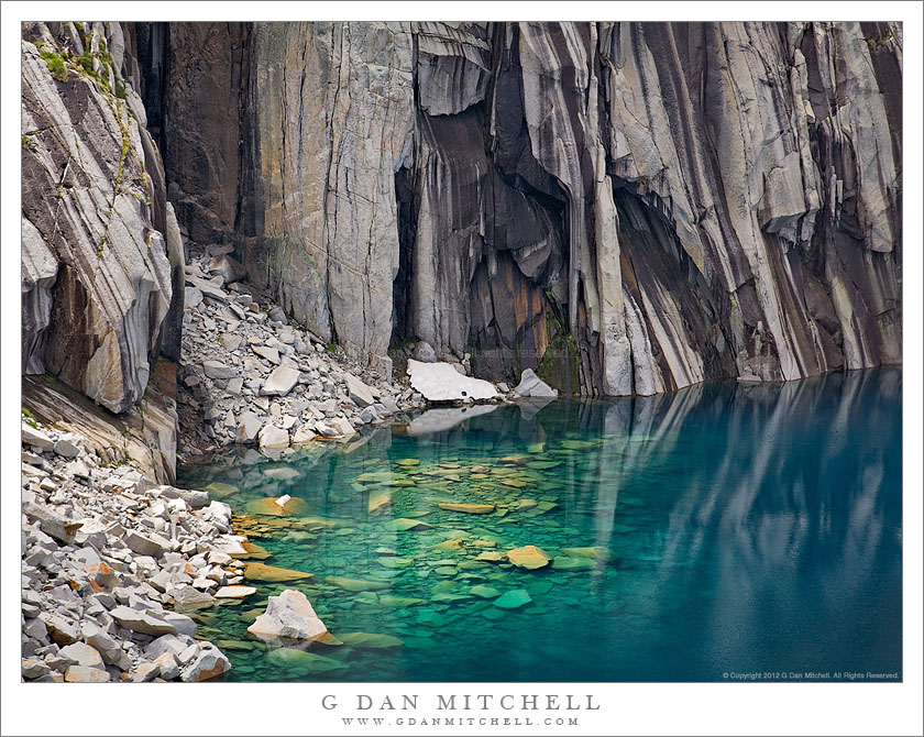
I have backpacked in California’s Sierra Nevada range for quite a few decades. A number (a large number!) of years ago my wife and I went on a two-week trans-Sierra backpack trip that traversed the range from west to east between Crescent Meadow and Whitney Portal, following a route known as the “High Sierra Trail.” On the third morning we left our camp and began the stiff ascent toward the pass we had to cross to enter the Kern River drainage. Near the top of the steepest part of the climb the trail momentarily leveled out and we found ourselves facing a high, rockbound lake with a perfectly vertical patterned rock face dropping straight into the water on the far side. The view seemed familiar – and I realized that it was a scene captured by Ansel Adams (“Frozen Lake and Cliffs“) in the early 1930s. (I also later realized that there is a wonderful and well-known photograph of the subject by Vern Clevenger.)
My wife and I were enthusiastic about photography in those days, too, and we carried a couple of Pentax SLRs and a few lenses and many rolls of film into the back-country. But I don’t think I came back with more than a few “snapshots” of this lake on that trip.
Fast-forward a few decades to 2008 when a group of my backpacking friends decided to follow this same trans-Sierra route — and, of course, I had to join them. Once again, I found myself ascending the trail toward that small bowl, but this time I had a plan to photograph the lake and the equipment to do it right. I recalled parts of the climb from my previous trip, but I had probably forgotten more than I remembered during the intervening decades. As the trail traverses a beautiful wet section full of wildflowers (which I had forgotten) I could tell that the lake was just ahead, and soon I topped a small saddle and saw the familiar scene before me.
As planned, I set to work doing some of the photography that I had contemplated before the trip. To be honest, I mainly worked from more or less the location that Adams must have used, though the conditions were a bit different on this day – the light was changeable as broken clouds passed above, and there was very little snow, much less ice, left at the lake. After perhaps 30 or 45 minutes of work, my hiking partners were getting restless and it was time to move on. I felt that I had worked this scene about as much as possible under the circumstances – and I did get a photograph of the “classic view” that I like a great deal — so I loaded up my heavy 9-day backpack load, put away the camera, and strapped the tripod to the outside of the pack. I hoisted the load and slowly started up the switchbacks immediately above the lake.
A couple of switchbacks up the trail I happened to look back at the lake from a slightly higher vantage point, and from here the astonishing deep blue color of the lake and the apron of rocks falling into the water became visible. My first reaction was a combination of “Wow!” and “No way am I taking this pack off and setting all that stuff up again!” Continue reading A Photograph Exposed: “Submerged Boulders, Lake, and Cliffs”→
“Dave” wrote to ask some questions about Death Valley in February, and I thought it might be useful to share my replies with others who are thinking about a visit to that localation.
• Jeep Wrangler good idea for the area and to get into the Racetrack?
First, I’ve posted here a few times about the logistics of visiting and photographing at the Racetrack – you might want to take a look at this post.
A Jeep Wrangler should get you out to the Racetrack Playa just fine. The main difficulties with the road involve very badly washboarded surface, some very gravelly spots (especially near the start), and the fact that you’ll cover 27 miles of this stuff one way. It is not a particularly steep or twisty road. In normal conditions I would feel OK doing it in a two wheel drive vehicle as long as it had good ground clearance and good tires – and the Wrangler should qualify.
Photographer and visual opportunist. Daily photos since 2005, plus articles, reviews, news, and ideas.
Manage Consent
To provide the best experiences, we use technologies like cookies to store and/or access device information. Consenting to these technologies will allow us to process data such as browsing behavior or unique IDs on this site. Not consenting or withdrawing consent, may adversely affect certain features and functions.
Functional
Always active
The technical storage or access is strictly necessary for the legitimate purpose of enabling the use of a specific service explicitly requested by the subscriber or user, or for the sole purpose of carrying out the transmission of a communication over an electronic communications network.
Preferences
The technical storage or access is necessary for the legitimate purpose of storing preferences that are not requested by the subscriber or user.
Statistics
The technical storage or access that is used exclusively for statistical purposes.The technical storage or access that is used exclusively for anonymous statistical purposes. Without a subpoena, voluntary compliance on the part of your Internet Service Provider, or additional records from a third party, information stored or retrieved for this purpose alone cannot usually be used to identify you.
Marketing
The technical storage or access is required to create user profiles to send advertising, or to track the user on a website or across several websites for similar marketing purposes.