Tag Archives: pass

Fall Aspen Trees, Country Road

Fall Aspen Trees, Country Road

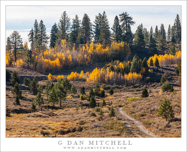
Fall Aspen Trees, Country Road. Near Monitor Pass, California. October 10, 2014. © Copyright 2014 G Dan Mitchell – all rights reserved.

A narrow gravel road approaches groves of brilliantly colored autumn aspen trees, Sierra Nevada

The eastern Sierra is full of fall color during the month of October, especially in areas where aspen trees grow. (The peak color is typically found sometime during the first two to three weeks of the month, though it varies depending upon a range of climate and local conditions.) Sierra aspens often have a different appearance from that which many expect if they have seen the big, tall, straight aspen groves in places like Colorado and Utah and similar. There are some groves like that in the Sierra, but they are unusual. Here the trees seem to have more varied form depending upon where they end up growing. In some places the trees are stout and thick but also quite twisted and gnarled. In others the trees are straight but very short. Along some creeks they grow so think that it is almost impossible to make your way inside the groves.

The trees in this photograph are perhaps typical, to the extent that it makes sense to speak of “typical” Sierra aspens. They grow at a relatively high elevation, on a ridge that is actually east of the true Sierra crest, and thus in a drier location. The trees are straight, but they are also not all that big. They are not part of a huge grove stretching across vast distances, but instead form a somewhat isolate grove — there are others nearby, but they are not connected.


G Dan Mitchell is a California photographer and visual opportunist whose subjects include the Pacific coast, redwood forests, central California oak/grasslands, the Sierra Nevada, California deserts, urban landscapes, night photography, and more.
Blog | About | Flickr | Twitter | FacebookGoogle+ | 500px.com | LinkedIn | Email

Text, photographs, and other media are © Copyright G Dan Mitchell (or others when indicated) and are not in the public domain and may not be used on websites, blogs, or in other media without advance permission from G Dan Mitchell.

An Incomplete Trip

(This is the first in what might become an occasional series of posts having little or nothing to do with photography—the “Not Photography” series for those of you who keep track of blog categories.)

A simple photograph of Duck Lake that I saw posted elsewhere today reminded me of a backpacking trip I did some years back, so I thought I’d tell a bit of that story here. It is not a story about photography, believe it or not, though I will add one gratuitous photograph “just because.” ;-)

Lakes Below Duck Pass, Afternoon Showers

Lakes Below Duck Pass, Afternoon Showers. Eastern Sierra Nevada, California. August 5, 2005. © Copyright 2005 G Dan Mitchell – all rights reserved.

I have backpacked for decades, almost entirely in California’s Sierra Nevada, visiting almost every portion of the range, though not by any means every place in this sierra of almost infinite variety. A few years back I made a rough tally of the total number of “trail days,” not counting non-backpacking trips, and it totaled up to something closer to two years than to one—and I’ve continued to backpack since that time.

Over the years I have covered the better part of the famous John Muir Trail (also called the “JMT”), but in pieces and spread over many trips. The trips have ranged from a couple of days in length, when I perhaps only touched a very short segment of the trail, up to several of two weeks or longer when I spent days along its length, often hiking alone but sometimes with friends, and on two memorable trips with my wife Patty. I’ve been over some sections quite a few times, including several areas in the Southern Sierra of Kings Canyon and Sequoia National Parks and a many in and around Yosemite. A few segments begin to feel like old friends when I return to them.

But there is one section that I have not yet covered. It stretches from Purple Lake to about the Muir Trail Ranch. 

Continue reading An Incomplete Trip

Titus Canyon Road

Titus Canyon Road
Titus Canyon Road

Titus Canyon Road. Death Valley National Park, California. December 11, 2013. © Copyright 2014 G Dan Mitchell – all rights reserved.

Titus Canyon Road descents into upper Titanothere Canyon before climbing to Red Pass

Early December is a fine time to be in Death Valley National Park, and I managed to spend five days there this past December. The weather is cooler this time of year – in fact, temperatures dropped into the upper twenties in the Valley during my visit and well down into the teens in some of the upper elevations that I visited during the pre-dawn hours. Although seasoned Death Valley visitors prefer to visit during the cooler months, things seem much quieter than a few months later in the spring. In fact, I almost had the entire Stovepipe Wells campground to myself on my first night!

The relative solitude extended to this day, on which I drove over the Amargosa Range via Titus Canyon Road, the rough back-country one-way route between the Amargosa Valley and Death Valley itself. I know this route fairly well, having been over it a number of times. I always start in the morning, and this trip was no exception – I was well out on to the route when the sun came up. Often I just take a few hours for the trip, stopping at a few key locations. But recently I have thought more about how I might photograph some of these places that I used to simply drive through, and on this visit I slowed way down and devoted almost the entire day to this area. The location in this photograph is an example of the sort of area that I might have just passed through in the past. Here the road traverses the upper reaches of a very large canyon that eventually spills out into Death Valley far below. The location from which I made the photograph marks the high point on the route, and I always stop there – but on some previous visits I have just regarded the terrain as being empty. It isn’t, and I’m learning to see it more clearly. Here the gravel road drops down from the previous ridge, winding through the rough and dry landscape to the bottom of the canyon and its dry stream bed before climbing steeply up to my camera position.

G Dan Mitchell is a California photographer and visual opportunist whose subjects include the Pacific coast, redwood forests, central California oak/grasslands, the Sierra Nevada, California deserts, urban landscapes, night photography, and more.
Blog | About | Flickr | Twitter | FacebookGoogle+ | 500px.com | LinkedIn | Email

Text, photographs, and other media are © Copyright G Dan Mitchell (or others when indicated) and are not in the public domain and may not be used on websites, blogs, or in other media without advance permission from G Dan Mitchell.

Autumn Snow, Hope Valley

Autumn Snow, Hope Valley

Autumn Snow, Hope Valley. Sierra Nevada, California. October 9, 2013. © Copyright 2013 G Dan Mitchell – all rights reserved.

Early autumn snow flurries in Hope Valley

On this early October drive across the Sierra, eventually heading for the town of Bishop, we crossed Carson Pass from west to east. The object of the drive was to photograph fall subjects on the east side of the range, but there was nothing to keep us from starting early – and we began searching out colorful autumn aspens and other subjects even before reaching the pass. Light snow started west of the pass, and when we stopped at the turn-out at the pass a decent amount of snow was falling, the wind was blowing, and it definitely felt like winter. Back in the car we started down the east side of the pass.

The snow continued as we took a short detour on a gravel side-road, then returned to the main highway to head east on highway 88 through Hope Valley. I first visited Hope Valley many years ago when I had just begun cross-country skiing, and today I often pass through on my aspen-hunting trips. The aspens were turning colors on this day, and if you look very closely you can see a very large grove of them in the distance through the snow. We briefly stopped at the turn-off to Luther Pass, where I made this photograph looking back up the creek that flows through the valley. Snow was falling and there was a thin layer of snow sticking to everything. As if to prove that photographers aren’t the only people nuts enough to stand around in the cold wind and snow, there was actually a fisherman along the creek just out of the frame to the right!

G Dan Mitchell is a California photographer and visual opportunist whose subjects include the Pacific coast, redwood forests, central California oak/grasslands, the Sierra Nevada, California deserts, urban landscapes, night photography, and more.
Blog | About | Flickr | Twitter | FacebookGoogle+ | 500px.com | LinkedIn | Email

Text, photographs, and other media are © Copyright G Dan Mitchell (or others when indicated) and are not in the public domain and may not be used on websites, blogs, or in other media without advance permission from G Dan Mitchell.