Tag Archives: playa

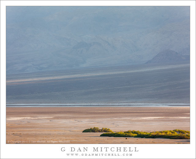
Death Valley, Evening

Death Valley, Evening
Evening light on the playa of Death Valley, with lower slopes of the Panamint Mountains rising beyond

Death Valley, Evening. Death Valley National Park, California. March 30, 2015. © Copyright 2015 G Dan Mitchell – all rights reserved.

Evening light on the playa of Death Valley, with lower slopes of the Panamint Mountains rising beyond

Since I’ve been traveling to and around Death Valley National Park for more than 15 years now, I’ve seen a lot of the park — but I most certainly have not see all of it, nor have I completely learned how to see everything in it. This is a huge place, varying greatly by location, terrain, season, weather and more. Frankly, the experience of coming to know such a place over time is one of the things I value most about such locations. While I love to “discover” a place that is completely new to me (and Death Valley was that place in the late 1990s for me), the longer process of learning the place and its rhythms more deeply is also, I think, more rewarding. It is wonderful to see a desert gully in evening light for the first time, but it may be even more beautiful to come back to it and recognize an old and familiar friend.

Along these lines, a few years ago, as I continued to push out my own boundaries of experience and knowledge in Death Valley, I began to think more about how to make photographs of things that I might have not thought worthy of a photograph before. I realized that many of these things that don’t scream “photograph me!” are otherwise a core part of the experience of this place: a vast and quiet “empty” landscape, midday sun, haze obscuring great distances, the edge between the last vegetation and a barren playa, a beam of light slanting across an alluvial fan. And if they are central to the sense of the place, it seems that there must be a way to photograph them. And that is a new challenge for me in my Death Valley photography.


G Dan Mitchell is a California photographer and visual opportunist whose subjects include the Pacific coast, redwood forests, central California oak/grasslands, the Sierra Nevada, California deserts, urban landscapes, night photography, and more.
Blog | About | Flickr | Twitter | FacebookGoogle+ | 500px.com | LinkedIn | Email

Text, photographs, and other media are © Copyright G Dan Mitchell (or others when indicated) and are not in the public domain and may not be used on websites, blogs, or in other media without advance permission from G Dan Mitchell.

Salt Flats and Waterways

Salt Flats and Waterways

Salt Flats and Waterways. Death Valley National Park, California. March 30, 2011. © Copyright 2013 G Dan Mitchell – all rights reserved.

Seasonal creeks twist though salt flats of Death Valley, Death Valley National Park, California

Since I have recently posted a few other photograph from this same location and with some of the same commentary that I might include here, I’ll try to keep this description a bit short. The photograph was made from the top of Dantes View, the Death Valley observation point that is about a mile above the lowest part of the Valley near Badwater. The panorama from Dantes View almost overwhelmingly expansive, so on this visit I though that rather than just trying to photograph that immensity, I would also use a long focal length lens to try to isolate and pick out some smaller portions of the overall scene.

This photograph shows a section of the salt flats, surrounded by browner areas that include more gravel. A darker foreground area that runs along the road is visible at the bottom of the photograph, and the upper corner includes the area where the West Side Drive runs between the flats and the lower slopes of the Panamint Range. The many waterways crossing the flats and then converging on the salt area are evidence of the role water plays in the creation of this barren terrain.

G Dan Mitchell is a California photographer and visual opportunist whose subjects include the Pacific coast, redwood forests, central California oak/grasslands, the Sierra Nevada, California deserts, urban landscapes, night photography, and more.
Blog | About | Flickr | Twitter | FacebookGoogle+ | 500px.com | LinkedIn | Email

Text, photographs, and other media are © Copyright G Dan Mitchell (or others when indicated) and are not in the public domain and may not be used on websites, blogs, or in other media without advance permission from G Dan Mitchell.
G Dan Mitchell Photographs at Stovepipe Wells

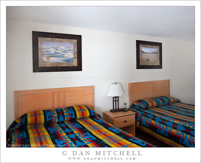
G Dan Mitchell Photographs, Stovepipe Wells Lodge

Stovepipe Wells Lodge – G Dan Mitchell photographs. Death Valley National Park, California. © Copyright G Dan Mitchell – all rights reserved.

Since several people have asked, I thought I would share an update on installation of my photographs at the historic Stovepipe Wells Lodge in Death Valley National Park. Late last year Ortega Family Enterprises (who also sell some of my photographs at Muir Woods National Monument) contacted me. They were about to take over the management of the facility from the previous concessionaire and were interested in selling some of my Death Valley photographs in the gift shop at Stovepipe Wells.

It turns out that they were also planning some significant upgrades to the lodging facilities at Stovepipe and they asked if I could provide a large number of 16″ x 24″ prints for the guest rooms. To make a long story short, they selected a half dozen of my Death Valley photographs and I went to work making nearly 170 prints of the six photographs, which were then shipped off to their framer for final preparation.

I finally got a chance to see the results when I visited Death Vally in early April. I stopped by and found out that they had begun the process of hanging the prints in guest rooms, and with the help of an employee I was able to get in long enough to snap a shot of one of the rooms. (Hanging in this room are Transverse Dunes, Death Valley and “Crossing Tracks, Racetrack Playa.”) It was also good to see some work being done to upgrade and update the lodge!

It is gratifying to have my photographs installed here for several reasons. Several of the photographs were made virtually within walking distance of Stovepipe Wells, where I often camp when I visit the Valley. I also know that among the many people who visit Stovepipe will be a good number of my fellow photographers – and knowing that they will see my prints here is both a bit intimidating and a quite exciting! Finally, before Ortega took over the facility I often stopped to look at some of the photographs and paintings that had been there previously. (I was glad to see that one wonderful black and white photograph was still hanging in the hotel office.) With that in mind, it seems like there is a good chance that these photographs of mine may be hanging in this historic facility for some time to come!

G Dan Mitchell Photography | Flickr | Twitter (follow me) | Facebook (“Like” my page) | LinkedIn | Email
Text, photographs, and other media are © Copyright G Dan Mitchell (or others when indicated) and are not in the public domain and may not be used on websites, blogs, or in other media without advance permission from G Dan Mitchell.
Playa Surface, Panamint Valley

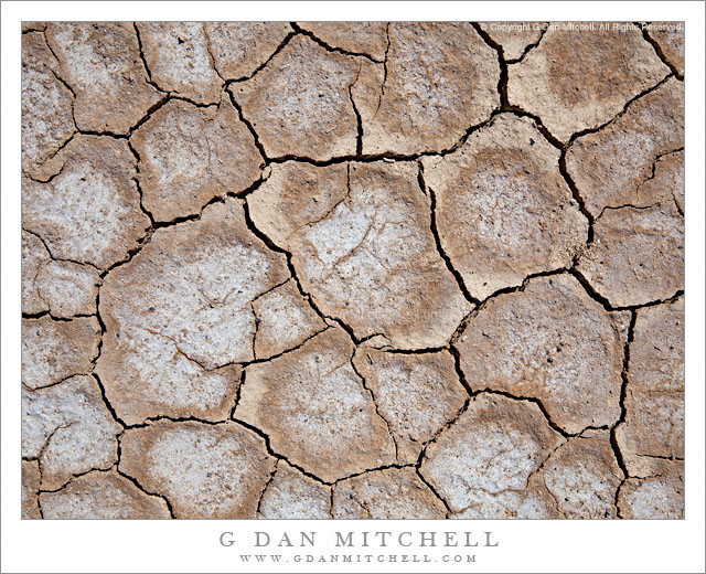
Playa Surface, Panamint Valley

Playa Surface, Panamint Valley. Death Valley National Park, California. March 31, 2011. © Copyright G Dan Mitchell – all rights reserved.

Cracked and dry surface of the playa in Panament Valley, Death Valley National Park.

This micro-scene could be found in many locations in Death Valley and, for that matter, in many places in the USA and around the rest of the planet. But my little rectangle of the patterns of drying and cracked mud comes from the surface of the Playa (sometimes called “Panamint Lake?”) in upper Panamint Valley in Death Valley National Park. I wrote previously that it was the last day of my late-March photographic visit to Death Valley – I had finished my photography in the main Valley and had started the long drive back to the Bay Area. After crossing Towne Pass the road descends into Panamint Valley to a junction where I most often go south towards Trona and Ridgecrest and beyond.

Just before this junction the road crosses the playa, an extraordinarily flat surface formed when silt washed down from the surrounding mountains occasionally pools and gradually dries, forming what may be the flattest surfaces on the planet. As the moisture evaporates the mud cracks and splits into these interesting semi-geometrical patterns.

For no particular reason other than that this is a spot where I often make one final stop before leaving the park, I pulled over and wandered out onto the playa. I enjoy walking on these often-immense flat surfaces, but there is something very odd about the experience, too. Perhaps it is the slightly odd feeling of walking on such a large floor-flat surface in the natural world, or it might be the deep silence and stillness. In any case, as I wandered around not too far from the road I started looking a bit more closely at the patterns of cracks and soon decided that my photography was not quite finished yet – so I went back to the car to get my camera and made a small series of hand-held photographs with the camera pointing straight down. (The “straight down” shooting raises a question: How should the photograph be oriented? The horizontal orientation shown here is what I saw as I made the photograph… but I also wonder about rotating it 90″ clockwise.)

G Dan Mitchell Photography | Flickr | Twitter (follow me) | Facebook (“Like” my page) | LinkedIn | Email
Text, photographs, and other media are © Copyright G Dan Mitchell (or others when indicated) and are not in the public domain and may not be used on websites, blogs, or in other media without advance permission from G Dan Mitchell.