
Tag Archives: travel

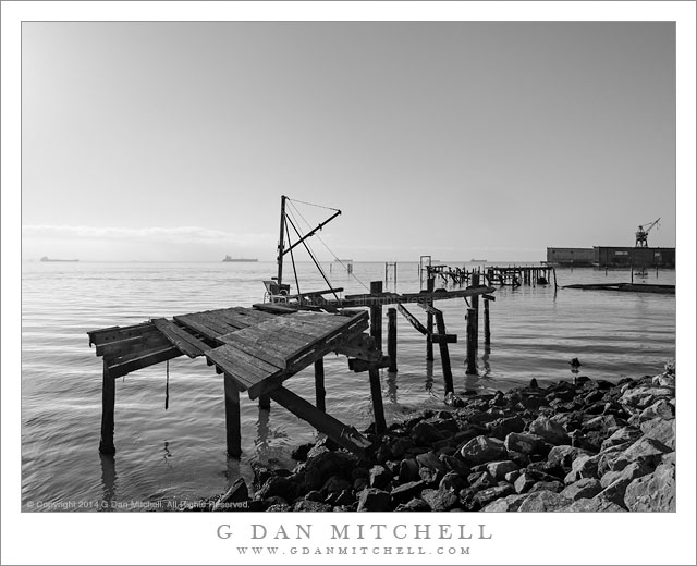
Abandoned Piers, San Francisco

Abandoned Piers, San Francisco

Abandoned Piers, San Francisco Bay. San Francisco, California. June 13, 2014. © Copyright 2014 G Dan Mitchell – all rights reserved.

Abandoned piers along the waterfront of the San Francisco Bay

I found this wonderful dilapidated and weathered structure while walking along a somewhat out-of-the-way section of the San Francisco Bay waterfront. Technically, it isn’t all that obscure, as there is a lot of new development going in not far from here, yet this specific spot and a few others in this area seem like they have not been touched in quite a while.

I’m a fan of photographing the Bay Shoreline early in the morning, when I can shoot into the rising sun, often with backlit fog and morning haze and occasionally with distant objects on the bay or along its far shore making faint appearances in the photograph. In this shot there are several very large tankers anchored far out in the bay along the horizon line, and beyond that the thinning fog still sits over the east bay shoreline. There are other surprises in this photograph, too. Among them are the odd lawn chair sitting precariously on the wreck of this old pier. Also in the frame are a nearly submerged collapsed pier a bit further off, a small row boat with several people in it, and one of the ship yard cranes that are found along the waterfront.

G Dan Mitchell is a California photographer and visual opportunist whose subjects include the Pacific coast, redwood forests, central California oak/grasslands, the Sierra Nevada, California deserts, urban landscapes, night photography, and more.
Blog | About | Flickr | Twitter | FacebookGoogle+ | 500px.com | LinkedIn | Email

Text, photographs, and other media are © Copyright G Dan Mitchell (or others when indicated) and are not in the public domain and may not be used on websites, blogs, or in other media without advance permission from G Dan Mitchell.
Golden Hills, Desert Sky

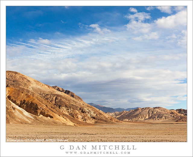
Golden Hills, Desert Sky

Golden Hills, Desert Sky. Death Valley National Park, California. April 31, 2014. © Copyright 2014 G Dan Mitchell – all rights reserved.

Early evening clouds fill the sky above golden hills, Death Valley National Park, California

Today’s photograph is about as much of a contrast with yesterday’s photograph (winter in Yosemite Valley) as you can find in California, though both were made at close to the same time of the year. This photograph comes from the golden hills and broad washes along the east side of Death Valley south of the Furnace Creek Area.

Earlier that afternoon we had arrived in the park for a visit of several days. After getting settled we had a bit of daylight time still in the late afternoon and early evening, so we headed south towards these clouds. (The clouds were perhaps a harbinger of the strange weather we would have later on during our visit, including a full day of very cold weather and even snow high in the Panamint Range.) Many of the hills in Death Valley are not exactly of brilliant colors—this desert is quite different from that of, say, Utah. But in this particular area colorful formations rise from the edge of the Valley, and the rocks that have washed down carry that color out into the Valley… at least if you happen to be there late in the afternoon before the sun drops behind the tall mountains on the other side of the valley.

G Dan Mitchell is a California photographer and visual opportunist whose subjects include the Pacific coast, redwood forests, central California oak/grasslands, the Sierra Nevada, California deserts, urban landscapes, night photography, and more.
Blog | About | Flickr | Twitter | FacebookGoogle+ | 500px.com | LinkedIn | Email

Text, photographs, and other media are © Copyright G Dan Mitchell (or others when indicated) and are not in the public domain and may not be used on websites, blogs, or in other media without advance permission from G Dan Mitchell.
Point Sur Lighthouse

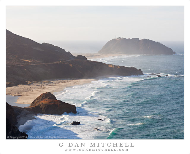
Point Sur Lighthouse

Point Sur Lighthouse. Pacific Coast Highway, California. January 31, 2014. © Copyright 2014 G Dan Mitchell – all rights reserved.

The lighthouse at Point Sur, Big Sur Coast

We are now very close to summer, the time of year when, frankly, the Pacific Coast can be somewhat less exciting from a photographic perspective. From my point of view, winter is the time to visit and the time to photograph. In a typical year (and this was not a typical year) a pattern repeats for several month. Big Pacific storms roll through, building giant surf, bringing rain, and then clearing. In the wake of the storms there may be a series of sunny days—sometimes warmer than summer here!—that are broken by beautiful clouds. The light is often spectacular, ranging from the brilliant light of clear weather to the moody light when the atmosphere is filled with moisture.

Near the end of this past January we travelled down this coast, on one of those “typical winter days” when there was plenty of bright sun, but also mist and spray thrown up by the ocean. This location is iconic along this section of the Pacific Coast Highway. Near the outlet of the Little Sur River, this “almost island” of Point Sur stands at the end of a strand of beach extending out into the ocean, and a historic lighthouse stands on top of the hill. Descending toward this point from the north, the view extends right along the rugged shoreline and beach just north of the Point.

G Dan Mitchell is a California photographer and visual opportunist whose subjects include the Pacific coast, redwood forests, central California oak/grasslands, the Sierra Nevada, California deserts, urban landscapes, night photography, and more.
Blog | About | Flickr | Twitter | FacebookGoogle+ | 500px.com | LinkedIn | Email

Text, photographs, and other media are © Copyright G Dan Mitchell (or others when indicated) and are not in the public domain and may not be used on websites, blogs, or in other media without advance permission from G Dan Mitchell.

Base of the Panamint Range

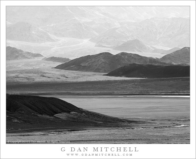
Base of the Panamint Range

Base of the Panamint Range. Death Valley National Park, California. April 1, 2014. © Copyright 2014 G Dan Mitchell – all rights reserved.

The lower reaches of the Panamint Range drop to the floor of Death Valley

The stillness of this image belies what was actually happening when I made the exposure. It was late afternoon, and the sun was just above the ridge of the Panamint Range as we drove down through Death Valley, past the Mustard Hills and towards Furnace Creek. As often happens in the spring, the winds were rising. I saw the scene and immediately knew I wanted to stop and photograph it, with the backlit hills rising across the far side of the Valley. I grabbed my tripod, camera, and one lens and headed across the side of a nearby hill that looked like it might provide me with a higher vantage point, and immediately recognized that wind was going to be a real problem.

The same wind that had filled the atmosphere with the beautiful haze that was glowing in the backlight was also making it nearly impossible to photograph. There are some winds that are strong enough that almost no tripod can hold a camera still, and this was that sort of situation. I set up, hanging onto the tripod to prevent it from blowing over, and waited for a lull in the wind. The wind momentarily diminished enough for me to make a few exposures as a cloud shadow darkened the foreground salt flats.

G Dan Mitchell is a California photographer and visual opportunist whose subjects include the Pacific coast, redwood forests, central California oak/grasslands, the Sierra Nevada, California deserts, urban landscapes, night photography, and more.
Blog | About | Flickr | Twitter | FacebookGoogle+ | 500px.com | LinkedIn | Email

Text, photographs, and other media are © Copyright G Dan Mitchell (or others when indicated) and are not in the public domain and may not be used on websites, blogs, or in other media without advance permission from G Dan Mitchell.