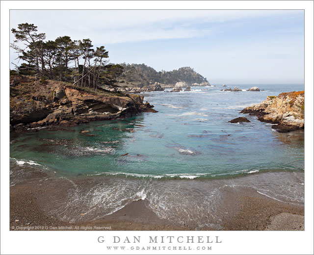
Coal Chute Point and The Pit. Point Lobos State Reserve, California. March 29, 2012. © Copyright 2012 G Dan Mitchell – all rights reserved.
Coal Chute Point, the Pit, and the rugged shoreline of Point Lobos State Reserve, California.
(Shortly after posting this, another photographer wrote to suggest that I might consider renaming the image to “Point and Chute.” ;-)
For all the years – decades, actually, and more than a few – that I’ve been visiting Point Lobos, there are still places that I have not gotten around to visiting within the boundaries of the park. Among them are some headlands not far from Whalers Cove that I’ve looked at for a long time… and then always headed off to some other part of the reserve without visiting them. Earlier this week I visited Point Lobos with no particular goal in mind aside from making some photographs, and I somehow finally ended up in this picturesque area that offers some quite different views from those found in the areas that more directly face out into the Pacific. (While it is, indeed, picturesque… the place names are not. Coal Chute Point? The Pit?)
The light in this photograph is somewhat subdued, at least in comparison to some of the photographs you might see of such a place, typically shot in the evening when the sky is at its most colorful. (Yes, I’ve certainly made my share of those photographs at Point Lobos, too!) But this light had a different sort of appeal, and it continuously changed during my half day there. When I arrived some fog was just clearing near the coast. It was a strange pattern – fog way inlands that looked more like the typical winter valley tule fog than the summer coastal fog. In fact, as is frequently the case in winter, it was clear at the coast. But somewhat surprisingly there was a regular old fog bank lurking a ways off the shoreline – and later in the day it moved in on the coast. Along with this there were high, thin clouds from a weather front that was passing well to the north. These conditions can still provide directional light but light which is softer and can fill in the shadows a bit – making it possible to shoot in places and at times of the day when the light might otherwise be too harsh. For this photograph I decided to “go wide,” and shoot with a 24mm focal length of a full frame DSLR to accentuate the distance between the foreground beach and the distant horizon and to include the full width of the curving wave as it broke on the beach.
G Dan Mitchell is a California photographer whose subjects include the Pacific coast, redwood forests, central California oak/grasslands, the Sierra Nevada, California deserts, urban landscapes, night photography, and more.
Blog | About | Flickr | Twitter | Facebook | Google+ | 500px.com | LinkedIn | Email
Text, photographs, and other media are © Copyright G Dan Mitchell (or others when indicated) and are not in the public domain and may not be used on websites, blogs, or in other media without advance permission from G Dan Mitchell.
Discover more from G Dan Mitchell Photography
Subscribe to get the latest posts sent to your email.


Tom, I missed the blue herons – though perhaps I wasn’t looking close enough – but I sure saw lots of harbor seals in Whalers Cove and in another cove out past Granite Point.
I wondered where in the heck that name (“The Pit” ) came from!
Dan
I am pleased to see that you got out to the east side of the Reserve. This is an interesting time to visit, there are Great Blue Herons nesting in the pines on Coal Chute Point and the Harbor Seals just started hauling out in Whaler’s Cove for pupping.
The place names harken back to when the Reserve was utilized as a resource. There was a coal chute on the point that provided low grade coal to passing steam ships. The Pit got its name because it was mined for pea gravel.