Category Archives: Photographs: Southern California

Lower Slopes of Tucki Mountain, Dawn

Lower Slopes of Tucki Mountain, Dawn

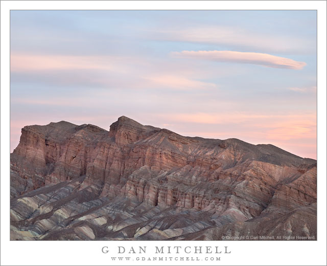
Lower Slopes of Tucki Mountain, Dawn. Death Valley National Park, California. March 31, 2011. © Copyright G Dan Mitchell – all rights reserved.

Dawn light on the faces and gullies of the lower slopes of Tucki Mountain, Death Valley National Park.

On the final morning of my recent (March, 2011) visit to Death Valley I decided to go to a spot not far from my campsite at Stovepipe Wells where I know of a bit of raised terrain that provides large-scale views of big chunks of this part of the Valley. I arrived before dawn and lugged my gear to the top of this rise with the primary plan of using a long lens to photograph across the Mesquite Dunes toward the Cottonwood Mountains at sunrise.

However, when standing in a spot like this one there are so many interesting effects of light all around that it is impossible, for me anyway, to just shoot that one thing. Far up the Valley to the north light starts to hit the highest peaks of several mountain ranges, to the east the light comes through and illuminates morning haze and layers of low hills, and to the southwest of my position the light began to reach the top of Tucki Mountain. So, between photographs of my intended subject to the west, I swung the camera though the entire 360 degrees to photograph many of these other subjects.

Tucki Mountain has fascinated me since I “discovered” it one morning while shooting on the “back side” of the Mesquite Dunes. At dawn I had been photographing the low dunes and other features on the side of the dunes that cannot be seen from the usual roadside viewpoints. As the light changed I worked my way up into the dunes a bit to photograph the shapes and textures of the sand, and I saw a composition that included this massive mountain to the south with it dark and jagged features. It was only later that I found out that it was Tucki Mountain. (If you have visited Stovepipe Wells, you have been right below the mountain.) It is a huge, sprawling peak – almost more of its own small range than a simple peak, or so it seems to me.

On this morning I first saw a big of the deep red first dawn light hitting the top of the peak and noticed lower ridges starting to pick up traces of this light. I swung that tripod head around to point this direction and decided to tightly frame some images of the overlapping ridges and valleys ascending toward the peak as the light worked its way down toward the Valley floor.

G Dan Mitchell Photography | Flickr | Twitter | Facebook | Email
Text, photographs, and other media are © Copyright G Dan Mitchell (or others when indicated) and are not in the public domain and may not be used on websites, blogs, or in other media without advance permission from G Dan Mitchell.

Red Cliffs, Dawn

Red Cliffs, Dawn
Red Cliffs, Dawn

The Red Cliffs (also called the “Red Cathedral”) are close to the famous spire of Manly Beacon at Zabriskie Point, and off the right a bit from the typical vantage points. The light was quite special – at least when not blocked by the clouds! – on this morning. These interesting clouds against the pastel blue sky first caught my attention, and were actually my primary interest in making this photograph. While the early light was on the clouds, some soft light also filtered through low clouds to the east and created a subtle glow on the face of this feature.

The Red Cliffs are really an amazing feature, though are often overlooked in favor of the more prominent and iconic Manly Beacon. The cliffs can often can be difficult to photograph – at least for me! When more direct light hits them the large dynamic contrasts between the areas in the light and the much darker shadows are tricky to handle, so this cloud-softened light seemed like just the right thing.

And, yes, I was at Zabriskie Point. It is a long story, but I have mentioned before that I have a personal project to photograph things other than the iconic scenes of Zabriskie. (Which is not to say that I won’t point my camera at those while I’m there it it turns out to be worth it!)


Leave a comment or question using the form. (If you are reading this on the home page, click the article title to see the full article and the comment form.

G Dan Mitchell is a California photographer and visual opportunist. His book, “California’s Fall Color: A Photographer’s Guide to Autumn in the Sierra” (Heyday Books) is available directly from him. Blog | Bluesky | Mastodon | Substack Notes | Flickr | Email

All media © Copyright G Dan Mitchell and others.

Trail Canyon, Lower Slopes of Wildrose Peak, Death Valley

Trail Canyon, Lower Slopes of Wildrose Peak, Death Valley

Trail Canyon, Lower Slopes of Wildrose Peak. Death Valley National Park, California. March 30, 2011. © Copyright G Dan Mitchell – all rights reserved.

Afternoon shadows fall across the lower slopes of Wildrose Peak above Trail Canyon and below Aguereberry Point, with Death Valley and the Black Mountains beyond.

The view from Aguereberry Point (and from this location close to the point) is spectacular and expansive, taking in everything from Death Valley itself, stretching almost 180 degrees from left to right, to the Green, Black, and other mountains beyond. To the south and north other ranges merge with the atmospheric haze. The peaks of the Panamint range lie behind, and in places where the view is clear you can look down on the rugged terrain of the east face of the Panamint Range with its rugged ridges and deep canyons dropping towards the Valley. This photograph looks roughly southeast towards the lower end of Death Valley in the area around Ashford Mill. The deep foreground canyon, the bottom of which is just visible at lower right, is Trail Canyon. I understand that a four-wheel-drive road used to come up to Aguereberry Point via that canyon, but that parts have washed out and it can no longer be driven. I think that you can hike it, but that would be one heck of a climb since the base of the canyon can’t be more than a few hundred feet above Death Valley (which is below sea level in this area) and the Point is well above 6000′. The lower slopes of Wildrose Peak rise beyond the canyon.

Surprisingly, this view presents several photographic challenges. Because of the haze that appears when such great distances are part of the scene, I chose to use a polarizing filter for this shot. Timing is important here, too. Arrive a bit too early and the light is harsh and flat. Arrive a bit too late and the foreground ridges are quickly enveloped in shadows as the sun drops behind the crest of the Panamint Range. (Yes, I have made both mistakes in the past.) Knowing this, I arrived a bit earlier than I might have usually arrive to shoot evening light and I managed to photograph the scene before that Panamint Range shadow obliterated the foreground light.

G Dan Mitchell Photography | Flickr | Twitter | Facebook | Email
Text, photographs, and other media are © Copyright G Dan Mitchell (or others when indicated) and are not in the public domain and may not be used on websites, blogs, or in other media without advance permission from G Dan Mitchell.

Mesquite Dunes and Cottonwood Mountains, Morning

Mesquite Dunes and Cottonwood Mountains, Morning

Mesquite Dunes and Cottonwood Mountains, Morning. Death Valley National Park, California. March 31, 2011. © Copyright G Dan Mitchell – all rights reserved.

Early morning light on Mesquite Dunes and the Cottonwood Mountains, Death Valley National Park.

This is one of the images I had in mind on the most recent late-March trip to Death Valley. When I visited earlier this year in February I started thinking about photographing the dawn light on the lower slopes of the Cottonwood Mountains along the west side of upper Death Valley. I had (and still have!) in mind several locations from which to explore this interesting terrain and light, but among them were a few that placed the Mesquite Dunes (a.k.a. “Death Valley Dunes”) in the foreground. (Why didn’t I shoot this subject back in February, you ask? The weather did not cooperate! There was rarely good light in the morning and, in fact, I had to deal with rain and snow on that visit!)

Besides finding a location from which to line up the elements of the shot, the other keys are having a long enough lens and, well, being there at the right time! And, as I was reminded in February, a bit of luck with the weather doesn’t hurt either. Although it had snowed and rained right before my arrival on this visit, this time the weather ended up being clear for the most part and was even turning downright hot by the time I left later on the day that this photograph was made.

G Dan Mitchell Photography | Flickr | Twitter | Facebook | Email
Text, photographs, and other media are © Copyright G Dan Mitchell (or others when indicated) and are not in the public domain and may not be used on websites, blogs, or in other media without advance permission from G Dan Mitchell.