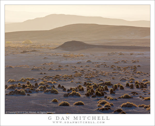
Tag Archives: atmospheric

Rock Garden, Atmospheric Haze, Morning

Rock Garden, Atmospheric Haze, Morning - Black and white photograph of a rock garden of sandstone towers in morning light, backed by atmospheric haze and barely visible La Salle Mountains, Arches National Park
Black and white photograph of a rock garden of sandstone towers in morning light, backed by atmospheric haze and barely visible La Salle Mountains, Arches National Park

Rock Garden, Atmospheric Haze, Morning. Arches National Park, Utah. April 7, 2012. © Copyright 2012 G Dan Mitchell – all rights reserved.

Black and white photograph of a rock garden of sandstone towers in morning light, backed by atmospheric haze and barely visible La Salle Mountains, Arches National Park.

So far, each time I’ve thought I was hitting the end of the photographs from my early April weeklong trip to Utah, I come up with another one… and another… and another. I still have a few more waiting to be posted, but those are photographs that I had already worked up but held off posting for one reason or another. This one, however, may be the final one to actually emerge from the collection of exposures from the trip. (But I make no promises! There is one more that features some reflected light inside alcoves in sandstone that still may work.)

This photographed ended up in black and white for several reasons. I was sort of leaning that direction when I made the exposure, since the color components of the scene were both difficult to work with and a bit less than exciting. In addition, I like the way that black and white can sometimes abstract the shapes of things, perhaps taking them a few degrees further from their “real” nature. I had stopped alongside the road between the Windows Area and Wall Street as I begin my exit from Arches National Park on my last morning of shooting there. There was a lot of haze, especially when looking into the light, as this photograph does. The backlit haze is thick enough that the snow- and forest-covered La Salle Mountains, which actually fill the upper part of the frame, all almost impossible to see, and the foreground features gradually lose contrast as they progress away from the camera. However, because the light is in front of the camera and coming from just out of the right side of the frame, the edges of the rock towers gain a bit of extra definition against that hazy background.

G Dan Mitchell is a California photographer whose subjects include the Pacific coast, redwood forests, central California oak/grasslands, the Sierra Nevada, California deserts, urban landscapes, night photography, and more.
Blog | About | Flickr | Twitter | FacebookGoogle+ | 500px.com | LinkedIn | Email

Text, photographs, and other media are © Copyright G Dan Mitchell (or others when indicated) and are not in the public domain and may not be used on websites, blogs, or in other media without advance permission from G Dan Mitchell.

‘Rim of the World’ Overlook, Morning

'Rim of the World' Overlook, Morning

‘Rim of the World’ Overlook, Morning. Sierra Nevada, California. May 7, 2011. © Copyright G Dan Mitchell – all rights reserved.

The view toward Yosemite and the High Sierra from the ‘Rim of the World’ overlook above the Tuolumne River canyon along highway 120.

‘Rim of the World’ is the name given to a scenic overlook above the deep valley of the Tuolumne River along route 120, the northern route into Yosemite National Park. It is something of an odd place. It is a fairly pedestrian traffic pullout, though it overlooks the immense and impressively deep canyon of the Tuolumne. But the view is at least partially obstructed by things like power lines. However, it is a view that on clear days can extend great distances to very high Sierra peaks.

I most often simply blow past the spot on my way to or from the park. However, on this morning as I passed I thought the low morning light looked interesting so I found a spot to turn around and drove back. There was a bit of high cloudiness, and the light was coming across the folds of these foreground hills from the right, lighting up various bits of ridge and trees and illuminating the morning haze enough to amplify the effect of distance. If I’m not mistaken, the further ridge with its faintly seen snow fields is in the area of Mount Hoffman.

G Dan Mitchell Photography | Flickr | Twitter (follow me) | Facebook (“Like” my page) | LinkedIn | Email
Text, photographs, and other media are © Copyright G Dan Mitchell (or others when indicated) and are not in the public domain and may not be used on websites, blogs, or in other media without advance permission from G Dan Mitchell.

Hills and Sunrise Haze, Death Valley

Hills and Sunrise Haze, Death Valley

Hills and Sunrise Haze. Death Valley National Park, California. March 31, 2011. © Copyright G Dan Mitchell – all rights reserved.

Sunrise light shines through morning haze to silhouette low hills in central Death Valley.

On the last morning of my late-March Death Valley shoot, I was on top of a low hill in roughly the middle of the Valley, not far from the “Devils Cornfield” area, mainly to photograph the Mesquite Dunes and the nearby transverse dunes against the backdrop of the Cottonwood Mountains. But this spot gave me a 360 degree panoramic view of a huge section of the central Valley, so while I waited for “just right” light on my intended subjects I also had time to see and photograph other subjects.

These low hills, mostly bare but sprinkled here and there with a few small plants or even a creosote bush or possibly a mesquite tree, were in the morning haze that sometimes settles in the bottom of the Valley before the daytime winds clear it out. The sun had just come over the Funeral Mountains to the east and was shining at a very low angle through this haze, so I pointed the camera (with a 400mm focal length lens!) almost straight into the sun (shading the lens with my hand) and made a few shots of these hills receding into the hazy distance across the Valley

G Dan Mitchell Photography | Flickr | Twitter | Facebook | Email
Text, photographs, and other media are © Copyright G Dan Mitchell (or others when indicated) and are not in the public domain and may not be used on websites, blogs, or in other media without advance permission from G Dan Mitchell.

From the Panamints to the Sierra, Evening

From the Panamints to the Sierra, Evening

From the Panamints to the Sierra, Evening. Death Valley National Park, California. March 30, 2011. © Copyright G Dan Mitchell – all rights reserved.

The Sierra Nevada in evening light as seen from Aguereberry Point in Death Valley National Park’s Panamint Range.

I made this photograph from Aguereberry Point shortly before sunset. Aguereberry Point is a lonely prominence over 6000′ above Death Valley, high in the Panamint Mountain range, a place of astonishing panoramic views – and often some significant winds. As I drove the gravel road to the point late in the afternoon I saw three or four other vehicles heading the other direction, but when I arrived at the point a bit more than an hour before sunset no one else was there.

Having photographed here a few times previously, I am becoming more familiar with the challenges and the opportunities of shooting here. One of the challenges – as is the case in many spots in Death Valley – is that certain subjects seem to be “photographable” at very specific times and only for short intervals. One of the most interesting views from Aguereberry is southeast down into Trail Canyon and on to the lower slopes of Wildrose Peak beyond. This is wild, rugged, austere terrain. However, because it lies on the east side of this range the light changes quickly from a washed out blast of daytime sun to sudden deep shadows as the sun drops behind the higher ridges of the Panamints. (Trail Canyon is not seen in this photograph.)

Another challenge is that, impressive and overwhelming as the scale of this grand scene is, it can be difficult to pull interesting compositions out of it. I tend to work with longer lenses here, both to isolate smaller areas out of the huge landscape and to compress distance. In this photograph, the silhouetted crest of the highest part of the Sierra Nevada range is on the horizon, with the intervening ridges of the Panamint Range and others probably including the Inyo Mountains and the ridge just west of Panamint Valley.

And, since I tend towards those large and long lenses… wind is an issue! And on top of Aguereberry Point there is nothing to stop the often strong winds of Death Valley. On this evening the winds were howling, so I found a spot below some rocks where it was a bit less windy and then spent a lot time waiting for momentary lulls in the wind when I could make photographs.

G Dan Mitchell Photography | Flickr | Twitter | Facebook | Email
Text, photographs, and other media are © Copyright G Dan Mitchell (or others when indicated) and are not in the public domain and may not be used on websites, blogs, or in other media without advance permission from G Dan Mitchell.