Tag Archives: burned

Rim Fire Zone, Morning

Rim Fire Zone, Morning

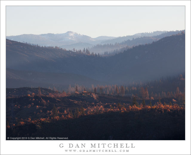
Rim Fire Zone, Morning. Rim of the World, California. October 30, 2013. © Copyright 2013 G Dan Mitchell – all rights reserved.

Hazy morning light filters across the burned hillsides in the area of the Rim Fire, California

In photographic terms this is perhaps not the most spectacular photograph, and the location is not quite a scenic icon – though it is a place that many stop and take a look on their way to Yosemite, the “Rim of the World” overlook along highway 120 between Groveland and the northern park entrance. However, this view is loaded with implications and connected to many stories.

Late this past summer, the state of California was tremendously dry after a second drought season. It wasn’t a question of whether there would be big wildfires, but more of where, when, and how many. Perhaps the biggest one of all started very near the Rim of the World overlook, and in the hot and dry conditions it quickly – some might say explosively – spread to the north, east, and south. While many think of it as “the Yosemite fire” – and it did burn a lot of terrain inside the park – it really was more of a “Yosemite area” fire. Because of the conditions – the long-term conditions of drought and the immediate conditions of heat and wind – the fire apparently did very serious damage to the forests in the are.

Shortly after the fire was contained, I thought that I might drive through the park on Tioga Pass Road to get to and from the eastern Sierra in early October. In fact, the roads had opened up again by that time, but snow closed Tioga Pass on my trip to the west and we ended up coming back over Sonora Pass. So the post-fire conditions of this area, which is very familiar to me after years of visits, were still an unknown when I drove to The Valley on October 30 for a few days of autumn photography. Passing into the first fringes of the burned areas along highway 120 things didn’t look all that different than they do after any wildfire – some areas badly burned, some singed, and others that mostly escaped the fire. I decided to stop at the Rim of the World overlook, which was pretty much the only place where stopping was allowed, and get out and take a look. I was floored by the scale of the fire. It had come from behind my position, burned down and across the deep canyon of the Tuolumne River, up the canyon walls on the far side, and then across a vast series of receding ridges. Some smoke and haze still seemed to be coming from the area, and early morning light glanced across the ridges, with their dead trees. In the far distance there is a low peak with a bit of early season snow.

I have seen quite a few fires in the park over the past few decades. One not far from here destroyed a large area of forest a few decades ago – and on this trip, ironically, I was noting that new evergreen trees are finally taking hold there. Later several very bad fires blew up from near Foresta, doing terrible damage to the section of Crane Flat Road descending towards The Valley. There have been others. In most of these cases – though I wondered in the case of the most recent Foresta fire, too – it seemed that I could watch the forest recover and return to something resembling what I remember. However, given the intensity and scale of this fire, I wonder if I’ll have that opportunity where the Rim Fire burned?

To end on a cheerier note, a couple of other observations. Even near badly burned areas, I did see sections where this fire only burned some of the vegetation and a few that seemed to have been completely spared. And when I got to a spot inside the park along highway 120 where I often stop to photography dogwood trees in the spring and fall, a spot that seemed like it might have been within the burn zone on the maps, I found my little spot completely intact, with the dogwoods turning to fall colors.

G Dan Mitchell is a California photographer and visual opportunist whose subjects include the Pacific coast, redwood forests, central California oak/grasslands, the Sierra Nevada, California deserts, urban landscapes, night photography, and more.
Blog | About | Flickr | Twitter | FacebookGoogle+ | 500px.com | LinkedIn | Email

Text, photographs, and other media are © Copyright G Dan Mitchell (or others when indicated) and are not in the public domain and may not be used on websites, blogs, or in other media without advance permission from G Dan Mitchell.

Merced River, Forest, Autumn

Merced River, Forest, Autumn

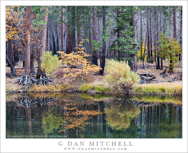
Merced River, Forest, Autumn. Yosemite Valley, California. October 31, 2013. © Copyright 2013 G Dan Mitchell – all rights reserved.

Colorful autumn trees among burned forest and reflected in the water of the Merced River, Yosemite Valley

This is, in several ways, a “quieter” photograph than some that I have posted recently. The location is along a section of the Merced River in Yosemite Valley that is probably not really seen by more than a handful of people, if that, on any given day.The spot is not special enough, if specialness is definable, to warrant its own particular name. (However, a few people do have a name for it – but it isn’t really to be shared here.) So the scene itself was, objectively speaking, quiet – the only others around were a couple of photographer friends working individually nearby, there was no wind, the river was as calm and quiet as I recall seeing it – barely even flowing, and almost nothing was moving in the forests along its banks.

There was another kind of quiet, too – the mental quiet that I often look for while photographing, especially in places like this. It is easy to let my mind wander – is this the right place to stop? should I check email before leaving the car? is there anything here that will make a great photograph? might it be easier to shoot someplace more predictably beautiful? what if I can’t find anything to shoot? Leaving my car behind and shouldering my tripod and bag of gear, I walked down to the river bank and began looking. My notions about what I might photograph are not so important – being open to what I might find to photograph is. When you first begin to photograph, it can sometimes take a long time to get into the frame of mind that allows you to slow down and become engrossed by what you see, to the point that you lose track of time and even where you are, focusing entirely on the seeing and the photographing. Eventually, I think you can learn to let this happen more quickly – not that it always does – and to avoid the trap of trying too hard to steer the process and to instead be quiet and open to what you see. And so, thinking back on this evening, as I made my last photographs before heading home, I recall the sense of quiet focus as much as the objective features of the scene itself.

G Dan Mitchell is a California photographer and visual opportunist whose subjects include the Pacific coast, redwood forests, central California oak/grasslands, the Sierra Nevada, California deserts, urban landscapes, night photography, and more.
Blog | About | Flickr | Twitter | FacebookGoogle+ | 500px.com | LinkedIn | Email

Text, photographs, and other media are © Copyright G Dan Mitchell (or others when indicated) and are not in the public domain and may not be used on websites, blogs, or in other media without advance permission from G Dan Mitchell.
Burned Forest, Evening

Burned Forest, Evening

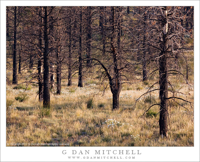
Burned Forest, Evening. Eastern Sierra Nevada, California. August 20, 2011. © Copyright 2011 G Dan Mitchell – all rights reserved.

Evening light on an eastern Sierra Nevada forest recovering from a recent wildfire.

This spot is in Mono County along highway 395 not far from June Lake, and it is a spot that I’ve had my eyes on for some time. As a person who was brought up in the “Smokey the Bear” era, when wildfires were thought to be entirely a bad thing, it took me a while to come to terms with the knowledge that such fires are a natural and necessary element. I understood this logically before I understood it aesthetically, and I struggled for some time with the idea that places where fires have occurred can be seen as sites of rebirth rather than as destruction and desolation.

I’ve been waiting for the right opportunity and the right light to photograph this burn area for a couple of years now. I pass by fairly often, but it has always been at the wrong time of day or at a time when I could not afford to stop. However, as is often the, unexpected coincidences caused me to be here just before sunset as the light turned golden in mid-August. Ironically, part of the cause was… a forest fire in Yosemite! Up in the Tuolumne area, the afternoon air had turned smokey and the light had taken on the sort of brownish color that forest fire smoke can create. This light was not inspiring me, so I thought that I’d drive over the pass and head south a short distance on highway 395 to see if I could find more interesting lighting. As I traveled south from Lee Vining I happened to notice the turn-off for West Portal Road, which heads out in the general direction of Mono Craters. I took this road and spent some time poking around, eventually making a few exposures in the area called Aeolian Buttes, and then returned to the main highway a bit south of where I had originally left the road.

As it happened, this choice dropped me onto 395 at a place where I could see this burned area just a bit further down the road. The sun was not far from dropping behind the Sierra crest, so I figured this could be my chance to give it a try. I found a spot where the late afternoon light was warming the color of the summer-dried grasses and some white flowers grew among the burned trees, and I had perhaps 15 minutes to work before the sun dropped behind the peaks.

G Dan Mitchell Photography
About | Flickr | Twitter | FacebookGoogle+ | 500px.com | LinkedIn | Email

Text, photographs, and other media are © Copyright G Dan Mitchell (or others when indicated) and are not in the public domain and may not be used on websites, blogs, or in other media without advance permission from G Dan Mitchell.

(Basic EXIF data may be available by “mousing over” large images in posts. Leave a comment if you want to know more.)