Tag Archives: highway

Cove and Beach Near Davenport, Evening

Cove and Beach Near Davenport, Evening

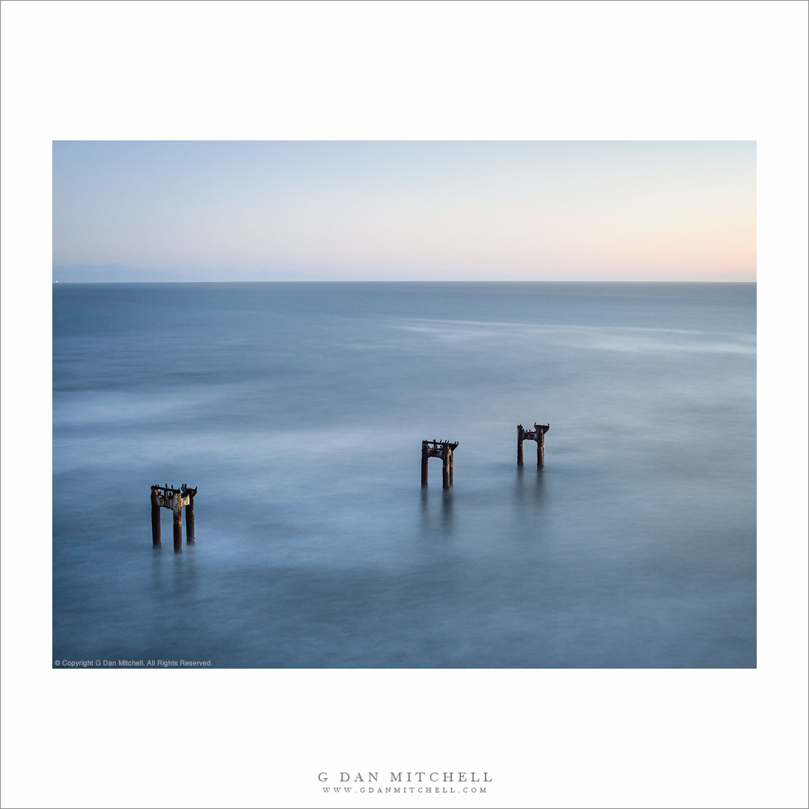
Cove and Beach Near Davenport, Evening. Davenport, California. December 12, 2010. © Copyright G Dan Mitchell – all rights reserved.

Black and white photograph of two people standing on a bluff above the Pacific Ocean and overlooking a cove and beach near Davenport California.

Although I have continued posting photographs at a rate of one per day, I have only managed to get into the field to shoot a few times since early November. Yesterday I found time to make it over to the Pacific coast late in the day. I was looking for the foggy, misty, and somewhat gray conditions that are common this time of year, at least when the air has not been cleared by a passing storm. I wasn’t disappointed. While the sky was clear overhead, the air was very moist – my equipment became damp from condensation as I worked.

Since my time was a bit limited – the sun was going down! – I went more or less straight to this spot where I have photographed in the past. (At first I considered going a bit further north to shoot from high bluffs, but I realized that the shot I had in mind from that location would be better earlier in the day.) When I arrived the sun was just dropping below the horizon, but that is what I wanted – I wasn’t looking for one of those brilliant “sun dead ahead” shots. I wanted the post-sunset soft light and enough darkness that I could work with longer exposures.

I parked and walked the short distance to this spot at the head of this cove. The composition is sort of tricky. The “right” (in my view) arrangement of the offshore rock and the surrounding bluffs can only be seen from a very small area – too far right or left and elements start to collide. In addition I wanted that little bit of more distant shoal along the right side of the frame to suggest that the coast continues, and I wanted that flat bit of bluff with a bit of post sunset light at the left. It was a bonus when the two people – probably photographers! – showed up on the top of the left bluff and thoughtfully posed for me as I made long exposures!

This photograph is not in the public domain and may not be used on websites, blogs, or in other media without advance permission from G Dan Mitchell.

G Dan Mitchell Photography
Flickr | Twitter | Facebook Fan Page | Facebook | Friendfeed | Email

McGee Canyon and Mount Morgan

McGee Canyon and Mount Morgan

McGee Canyon and Mount Morgan. Owens Valley, California. October 10, 2010. © Copyright G Dan Mitchell – all rights reserved.

Snow crested Mount Morgan rises above McGee Canyon and the sagebrush-covered hills of Owens Valley in the eastern Sierra Nevada.

I’ve been traveling to the Sierra for many years. My first recollection of the range is a faint mental image of a shoreline park at Lake Tahoe when my family moved to California – I was four years old. My next memory is of staying at a small motel in El Portal next to the high water of the Merced River back in the days before the current mega-hotels were erected. One thing that all of my early Sierra experiences had in common is that I always approached the range from the west since I lived (and still live) in the San Francisco Bay Area. For the person whose orientation to the range is from the west, the Sierras are a range that begins almost imperceptibly in the Central Valley. Although you can see distant peaks from the Valley on clear days, it is hard to say where the range begins. As you head east you encounter some very small and rounded hills which gradually get larger. Eventually you are going up more than up and down as you  travel through oak and grass lands. At some point the road rises into forest, but the mountain tops are mostly rounded and forest covered. Keep going and a few rocky prominences begin to appear along the ridges and some distant granite peaks become visible. Only after a lot of driving do you find yourself in the higher reaches of the range, and this only in the few areas where roads cross from west to east. In most places you cannot even see the summit of the range close up from the west without walking a long ways.

It was only many years later that I first went over the summit of the range and saw it from the east side. The Sierra is (are?) completely different when approached this way. Instead of a long, gradual, and relatively gentle rise to high valleys and forests and meadows, the eastern escarpment of the Sierra rises abruptly – one might say violently – and directly, in most places, from the high desert sagebrush country of Owens Valley and similar places. This wall of peaks seems almost inaccessible, and I imagine that many people who only drive past on highway 395 must regard it that way.

This photograph was made from a spot just a mile or two east of highway 395, out an a gravel road that I know. I have photographed this shadowed foreground ridge and the peaks beyond in the past, so I had a fairly good idea of what I would find at this location before I made the photograph on an early October morning when fall storms had dusted the highest peaks with snow. I used a somewhat long lens and tight framing to emphasize the rise from the foreground desert to the very high peaks beyond.

This photograph is not in the public domain and may not be used on websites, blogs, or in other media without advance permission from G Dan Mitchell.

G Dan Mitchell Photography
Flickr | Twitter | Facebook Fan Page | Facebook | Friendfeed | Email

Abandoned Pier, Dusk

Abandoned Pier, Dusk
“Abandoned Pier, Dusk” — The pilings of a long-abandoned pier on the Pacific coast near Davenport, California.

Besides being a matter of hours from the Sierra Nevada and less than a day’s drive from places like Death Valley, I can be at the Pacific coast between San Francisco and Santa Cruz in barely more than a half hour. Yesterday it looked like evening conditions might be interesting so I headed over there in the late afternoon. As I crossed the mountains on my way there I was pleasantly surprised to see low clouds over the ridges and some higher clouds over towards the ocean, which got my hopes up for some sort of spectacular evening light. However, when I actually got the the coast the conditions were not as interesting – mostly clear with just a bit of cloudiness on the horizon, and no interesting haze or mist over the water. Either that or I just wasn’t “seeing it” this time. So, after stopping for a cup of coffee, I headed up the coast from Santa Cruz and stopped at several of the usual locations, but didn’t make a single exposure. At the northernmost point on my drive I stopped right by the water and it looked like interesting light might be five or ten minutes away… and then the sun dropped below some low clouds near the horizon and the light died!

I think I’ve learned to go with the flow when this happens. I react in several ways. One is to look around for subjects other than those that I thought I was there for. With that in mind I thought about photographing shore birds… but there was only one forlorn seagull down near the water. I saw an interesting pool of water on the beach and thought it might play into a seascape photograph, but the flat light and cloudless sky was not working. I remembered a spot a bit further south where I had once shot some shoreline shoals from the top of a steep cliff at sunset, so I quickly drove up that way… and couldn’t find them!

I had one final thought. On the way north I had seen a group of photographers on the bluff near the northern edge of Davenport. I had stopped, leaving my camera equipment in the car, and quickly dashed out to where they were set up to see what was so interesting. Below their position were the four remaining supports from an old pier that washed away many years ago. It looked interesting and I recognized the structure from photographs that others have made from down on the beach – but I hadn’t been up for the steep descent to the beach so I had driven on after making a mental note about a position from which I thought a photograph might be made. Now I realized that if I went straight there that I might be able to make some long exposures in the dying light and perhaps frame them so that they only contained the structures and the open sea. So, off I went.

I arrived just before the moment of sunset and, sure enough, the group of photographers I had seen earlier was still there. I grabbed my gear and quickly walked out to the point I had scoped out earlier, which was some distance from where they were set up. I framed up this composition and then photographed right though sunset until there wasn’t really enough light to keep shooting. (The group at one point looked like they thought the show was over and they were going to leave, but I think they saw me continuing to shoot and decided to stick around almost as long as I did.) The light just kept getting more interesting as it faded. Although it was too dark to really see the image as it appears here, I knew that this three minute exposure (intentionally lengthened by choosing a small aperture and low ISO) would smooth out the surface of the water but still show the shadows and reflections of the old pilings.


Leave a comment or question using the form. (If you are reading this on the home page, click the article title to see the full article and the comment form.

G Dan Mitchell is a California photographer and visual opportunist. His book, “California’s Fall Color: A Photographer’s Guide to Autumn in the Sierra” (Heyday Books) is available directly from him. Blog | Bluesky | Mastodon | Substack Notes | Flickr | Email

All media © Copyright G Dan Mitchell and others.

Grazing Cattle and Aspen Groves, Conway Summit

Grazing Cattle and Aspen Groves, Conway Summit

Grazing Cattle and Aspen Groves, Conway Summit. Sierra Nevada, California. October 10, 2010. © Copyright G Dan Mitchell – all rights reserved.

Cattle graze in front of large aspen groves near Conway Summit, California.

Just about anyone who has every photographed aspens in the area around Lee Vining is probably familiar with this location – and I’ve certainly shot there quite a few times. From highway 395 the aspens extend west and up toward the peaks of the Sierra crest, and the at the right hour in the late afternoon the backlight can light up the leaves of the trees. When I visited this time the trees were in transition with some still green, others very colorful, and some almost leafless already. I was also lucky to have some clouds at the end of several cloudless days of photography. (Normal people like perfect blue sky, but photographers are not normal – we tend to like weather!) When I saw the clouds starting to form above the crest early in the afternoon I thought that something interesting might happen later near Conway so I made a point of heading that direction.

This photograph features, of all things, cattle – not my usual subject, perhaps! The area where these aspens grow seems to be at least as much a pasture as it is aspen groves, and I’ve seen cattle grazing in this spot before. (See comments for a note from a member of the family that owns the land.) As the clouds created shadows over the higher slopes in the background, for a moment the sun still hit the foreground trees and these cattle.

This shot also ties in with my recent post on using various focal lengths for landscape photography, in that this photograph was made with what some might regard as an unlikely landscape lens, a 100-400mm zoom! But in this case, this lens at 250mm was just what I needed to more tightly frame the bit of foreground pasture and sunlit trees and compress the distance between them and the shadowed hills beyond.

This photograph is not in the public domain and may not be used on websites, blogs, or in other media without advance permission from G Dan Mitchell.

G Dan Mitchell Photography | Twitter | Friendfeed | Facebook | Facebook Fan Page | Email