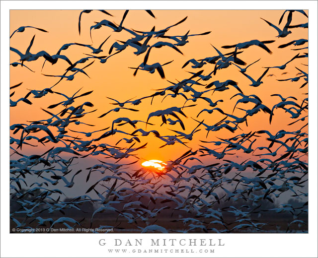
Tag Archives: mountains

Desert Sky, Negit Island

Desert Sky, Negit Island

Desert Sky, Negit Island. Mono Lake, California. August 5, 2013. © Copyright 2013 G Dan Mitchell – all rights reserved.

Mono Lake and dark Negit Island beneath a vast and cloud-filled summer sky

Mono Lake still seems like a somewhat mysterious place to me. Although I’m familiar with parts of it, having gone by and to it for many years on Sierra trips and having photographed there many times, I find it hard to quite get my mind around it in the same way that I can with many other places. There are probably several factors that contribute to this. First, it is obviously an absolutely huge place. While I can see the far side of the lake and the mountains beyond, they are a great distance away, as I’ve realized when traveling just part way around it – so I have looked at much of it but I have not directly experienced that much of it close up. Second, we feel that we know the chief features of this lake very well – they are, I suppose, the lowering water level of this close-off basin lake, its tremendous size, the mineral-filled water, and the famous tufa formations. But a bit more time, even only that time that I’ve spent there that is mostly secondary to “Sierra time,” and it starts to be clear that these things are not the whole story.

Some years ago, when photographing the tufas around dawn, mostly when almost no one else was around, I began to catch on to the fact that things like the sounds of flocks of birds, the immense distances on land and – especially – in the huge sky, the wind, and the deep quiet of the place have more to do with its character than the tufas. Often when I stop there now I do not go to the tufas at all, instead perhaps expanding my knowledge of other areas of the lake and surrounding country. This photograph was made from above the lake, in a location where I could look slightly down on the water, which better shows its expanse, and on the dark shape of volcanic Negit Island. But I chose to include them primarily not for their own value but rather to anchor that vast sky with its building afternoon clouds.

G Dan Mitchell is a California photographer and visual opportunist whose subjects include the Pacific coast, redwood forests, central California oak/grasslands, the Sierra Nevada, California deserts, urban landscapes, night photography, and more.
Blog | About | Flickr | Twitter | FacebookGoogle+ | 500px.com | LinkedIn | Email

Text, photographs, and other media are © Copyright G Dan Mitchell (or others when indicated) and are not in the public domain and may not be used on websites, blogs, or in other media without advance permission from G Dan Mitchell.

Cove and Wave

Cove and Wave
Cove and Wave

Cove and Wave. Point Lobos State Reserve, California April 21, 2013. © Copyright 2013 G Dan Mitchell – all rights reserved.

A wave washes into a small cove and onto a pebble beach along California’s coastline south of Monterey

I went down to the Monterey, Carmel, and upper Big Sur coast on what seemed like the first warm-season day of the year. I have probably mentioned before that I prefer the off-season for photography – that time of year when there are storms, giant waves, clouds, rain, cold, and all sorts of interesting conditions. As odd as it may sound, I tend to almost stay away from the coast when the weather becomes too nice! (Of course, there is always fog. And in the summer along the Pacific coast, I do mean “always.”) At the first place I stopped to photograph I was feeling a bit of the letdown from the beautiful morning… but as I got out of my car and stood there in shirt-sleeve weather, warm and no wind, and looked out over the slightly misty coastline I started to feel a bit better about warm weather. :-)

A bit later I headed back toward Point Lobos, where I found a bit more surf than I might have expected, and the high tide had brought the water in close to the shoreline. Here I set up right at the edge of a low bluff above this pebble-filled beach, put a wide-angle lens on the camera, and made some photographs of the near-perfect curve of the waves entering the cove and washing up onto the beach, with sea stacks further down the coast line.

G Dan Mitchell is a California photographer and visual opportunist whose subjects include the Pacific coast, redwood forests, central California oak/grasslands, the Sierra Nevada, California deserts, urban landscapes, night photography, and more.
Blog | About | Flickr | Twitter | FacebookGoogle+ | 500px.com | LinkedIn | Email

Text, photographs, and other media are © Copyright G Dan Mitchell (or others when indicated) and are not in the public domain and may not be used on websites, blogs, or in other media without advance permission from G Dan Mitchell.

Cliff-Edge Forest Above Werfen

Cliff-Edge Forest Above Werfen

Cliff-Edge Forest Above Werfen. Near Eisriesenwelt Ice Caves, Austria. July 19, 2013. © Copyright 2013 G Dan Mitchell – all rights reserved.

Forest trees and grassy meadow at the edge of a cliff above the town of Werfen, Austria

For looking to be such an astonishingly exposed location, this spot was actually quite easy to get to. Sorry if I disappoint anyone! ;-) Above the town of Werfen, Austria, not far from Salzburg, is a feature known as the Eisriesenwelt Ice Cave. It is a well-known and popular tourist destination, and since our “guides” (family members who live in Germany) suggested it, we went and joined the other tourists. Although this post isn’t really about the ice cave, I’ll at least mention that it is quite a spectacular thing to visit. The cave itself is quite something, but so is the process of getting to it. The cave is located very high up the face of a cliff above the Salzach River valley, in a place that you would hardly imagine would be accessible by normal folks. However, a combination of hiking, taking a ski-lift style tram, and then hiking some more, this time on a well-constructed trail across the face of the cliff, brings you to the entrance to the cave.

After we finished our tour of the cave we emerged into the sunlight to see that it was clouding up. As we hiked down to the upper tram station we began to hear some distant thunder. The moist atmosphere became thick, and although it was still mostly sunny in the valley below, many of the distant valleys and ridges were becoming partially obscured. At one point the trail followed the contour of a small gully and looped back away from the cliff edge, affording a view back across this bit of meadow and forest that ended abruptly at the edge of the void where the cliff dropped to the Salzach Valley below.

G Dan Mitchell is a California photographer and visual opportunist whose subjects include the Pacific coast, redwood forests, central California oak/grasslands, the Sierra Nevada, California deserts, urban landscapes, night photography, and more.
Blog | About | Flickr | Twitter | FacebookGoogle+ | 500px.com | LinkedIn | Email

Text, photographs, and other media are © Copyright G Dan Mitchell (or others when indicated) and are not in the public domain and may not be used on websites, blogs, or in other media without advance permission from G Dan Mitchell.

Boulders, Tree, and Dark Granite

Boulders, Tree, and Dark Granite

Boulders, Tree, and Dark Granite. Yosemite National Park, California. August 6, 2013. © Copyright 2013 G Dan Mitchell – all rights reserved.

A solitary tree stands on granite slabs among glacial erratic boulders against the dark background of a granite face in shadow

I have previously posted a few photographs from this early August four-day shoot in Yosemite, when I ranged between about Olmsted Point and Mono Lake for about four days. The photography was a bit strange compared to more normal years – there was smoke in the air from a fire near Mammoth Lakes and there was not much water due to the drought afflicting the mountains after a second very dry winter. So some of my photography instincts may have been challenged a bit, and I had to adapt to conditions – sometimes ending up shooting in a different place than planned when the haze was too thick, sometimes using the haze as part of the photograph, and also ranging a bit more widely than I might usually do.

On this morning I had decided to “work” that area between roughly Tenaya Lake and some rocky slabs a bit past Olmsted Point. I began at Tenaya just before sunrise, but the smoke haze was making things difficult. I made a few photographs along the curving shore as the first sun hit nearby ridges, but I wasn’t especially happy with the atmosphere or the color and quality of the light so I moved on. The slabs and domes along the road to the west of Tenaya Lake, which track the road for some distance and spread well beyond the road itself, have been an ongoing subject of interest to me. While the sun had hit the highest peaks by the time I got there, it had not quite worked its way down to these slabs, so I found some likely groups of glacial erratic boulders and various small trees and made some photographs. In this one, a single tree stands beyond a group of large boulders that had just been hit by the first light, and across a nearby canyon large granite walls are still in shadow.

G Dan Mitchell is a California photographer and visual opportunist whose subjects include the Pacific coast, redwood forests, central California oak/grasslands, the Sierra Nevada, California deserts, urban landscapes, night photography, and more.
Blog | About | Flickr | Twitter | FacebookGoogle+ | 500px.com | LinkedIn | Email

Text, photographs, and other media are © Copyright G Dan Mitchell (or others when indicated) and are not in the public domain and may not be used on websites, blogs, or in other media without advance permission from G Dan Mitchell.