Tag Archives: national monument

Sunset, Carrizo Plain

Sunset, Carrizo Plain
A sunset view down toward the edge of the Temblor Hills toward Carrizo Plain, lakes, and distant mountains

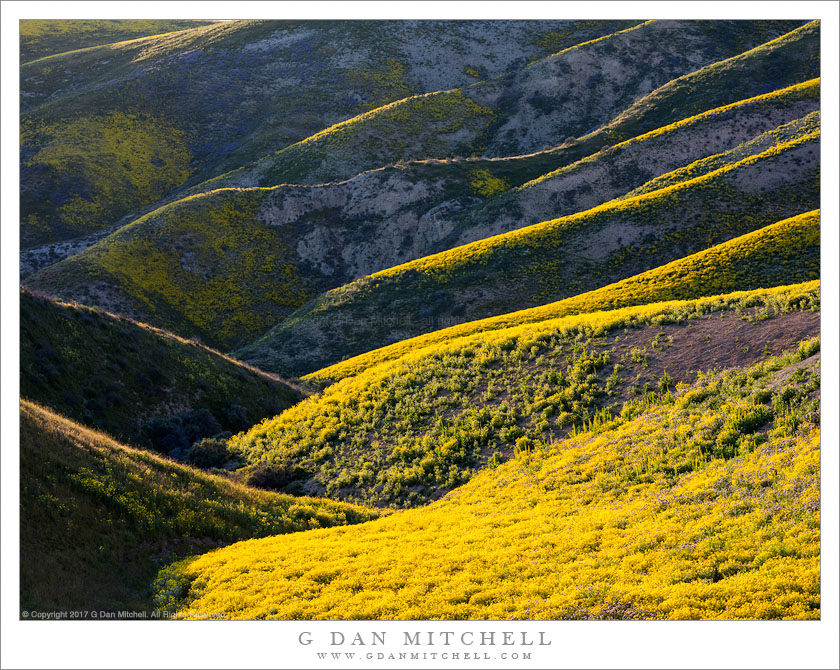
Sunset, Carrizo Plain. Carrizo Plain National Monument, California. April 2, 2017. © Copyright 2017 G Dan Mitchell – all rights reserved.

A sunset view down toward the edge of the Temblor Hills toward Carrizo Plain, lakes, and distant mountains

This has been — and likely will continue to be — and exceptional spring for California wildflower color. After an extended and historic drought that lasted roughly five years, the rainy season now coming to an end has been record-setting in the opposite direction. We’ve had floods, washing out highways, remarkable snowfall, and as of this week the state produced an all-time record for seasonal precipitation in portions of the norther Sierra Nevada. The natural world seems to have come back to life again, and in places that have been arid for the past few years we are now seeing lush green spring growth and lots of wildflowers.

Many of us decided to visit some of the interior locations where the seasonal grasslands can produce impressive wildflower blooms. On my way to Death Valley during the first week of April I detoured to join friends who were already in the Carrizo Plains region, and I managed to do one evening and one morning of photography there. On the first evening we found a somewhat remote area in the hills alongside the plain where we could see some large fields of flowers above, and we headed up into the hills to photograph them. From this elevation the views of the Plain opened up, and I made this photograph during the final minutes before sunset.


G Dan Mitchell is a California photographer and visual opportunist. His book, “California’s Fall Color: A Photographer’s Guide to Autumn in the Sierra” is available from Heyday Books and Amazon.
Blog | About | Flickr | Twitter | FacebookGoogle+ | LinkedIn | Email


All media © Copyright G Dan Mitchell and others as indicated. Any use requires advance permission from G Dan Mitchell.

Flower-Covered Hills

Flower-Covered Hills
Spring wildflowers in the Temblor Range, California

Flower-Covered Hills. Carrizo Plain National Monument, California. April 2, 2017. © Copyright 2017 G Dan Mitchell – all rights reserved.

Spring wildflowers in the Temblor Range, California

I made several photographs of this little valley, with its large number of small receding ridges, covered with flowers and separated by small gullies. We had gone out searching for wildflower prospects in the evening. We drove up into the hills on a one-lane gravel road and eventually found ourselves at a dead-end where the road was closed. We got out, loaded up packs with camera equipment, and continued on up into the Temblor Hills foothills. We left the trail, crossed gully, found a route along and ascending ridge, and before long we were high enough to gain a panoramic view of the Carrizo Plains, and we began to encounter more and more flowers.

After we arrived at the highest point on our hike, which was still far below the summit of these mountains, we set about making photographs. We started on the broad summit of a nearby hill, and from there we could look across a small valley toward these hills, where a series of small ridges ascended toward the evening light. Although there were probably a bit early for the true peak of wildflower color in this spot, there were still thick beds of yellow flowers almost everywhere.

Note: This scene is very similar to that in a photograph I shared just a few days ago. As sometimes happens — especially with my idiosyncratic workflow! — I sometimes end up thinking that my second choice pleases me more than my first.


G Dan Mitchell is a California photographer and visual opportunist. His book, “California’s Fall Color: A Photographer’s Guide to Autumn in the Sierra” is available from Heyday Books and Amazon.
Blog | About | Flickr | Twitter | FacebookGoogle+ | LinkedIn | Email


All media © Copyright G Dan Mitchell and others as indicated. Any use requires advance permission from G Dan Mitchell.

Dead Trees, Sandstone Pothole

Dead Trees, Sandstone Pothole
Dead trees lie at the bottom of a deep sandstone pothole, Grand Staircase-Escalante National Monument

Dead Trees, Sandstone Pothole. Grand Staircase-Escalante National Monument, Utah. October 23. 2014. © Copyright 2014 G Dan Mitchell – all rights reserved.

Dead trees lie at the bottom of a deep sandstone pothole, Grand Staircase-Escalante National Monument

There are multiple ways to react to the remarkable sandstone potholes from this terrain of rounded sandstone hills and gentle slabs. First of all, they are remarkable structures. They are simply “holes” in the sandstone — but surprisingly large holes. They are many feet across and perhaps 15-20 feet deep. They have no outlet, and you can imagine that with the right water source they would make rather gigantic swimming holes. Their source is not immediately apparent, though I understand that they are created over a long period of time by the forces of wind and water on the relatively soft sandstone.

They are beautiful, too. Their smooth, curving shapes have an almost sensuous quality, made stronger by the warm colors of the sandstone rock. Surprisingly, plants and even trees grow at the bottom of many of them. But these potholes may also be traps — there is no way out of their depths except for those creatures that can fly. In the middle or relatively smooth expanses of sandstone, these pits appear suddenly, and the angles at their edges quickly increase to vertical, making them potentially dangerous. The pothole in this photograph seems to me to have a bit less of the rock garden quality and a bit more of the ominous quality, with two dead cottonwood trees and broken branches littering the bottom of the pit.


G Dan Mitchell is a California photographer and visual opportunist. Blog | About | Flickr | Twitter | FacebookGoogle+ | 500px.com | LinkedIn | Email


All media © Copyright G Dan Mitchell and others as indicated. Any use requires advance permission from G Dan Mitchell.

Dry Mud and Sand

Dry Mud and Sand
Dry, cracked mud on top of red sand under reflected canyon light, Grand Staircase-Escalante National Monument

Dry Mud and Sand. Grand Staircase-Escalante National Monument, Utah. October 25, 2014. © Copyright 2014 G Dan Mitchell – all rights reserved.

Dry, cracked mud on top of red sand under reflected canyon light, Grand Staircase-Escalante National Monument

I almost titled this photograph, “Another Photograph of Mud.” But I have resisted that temptation, and once again used a simple more or less objective title. But, indeed, this is almost a photographic type when it comes to the Southwest, and one that is awfully difficult to pass up. These formations come about when silt-laden water rushes down desert canyons, washes, and streams, leaving behind a layer of very wet silt. The layer may be thin, as it was in this case, or it may be quite thick. In one narrow canyon last year I slipped into such silt-mud and it almost seemed like there was not bottom!

I’m not sure quite what explains our fascination with these formations. Is it because they are among the most transient features of the physical landscape, disappearing and then reforming every time it rains? Is it the patterns themselves, which can have a wonderful geometric quality and, at the same time, embody a randomness? Is it the combination of the colors of the material, which can range from white through black with many colors in between, and the reflected canyon light? Possibly it is all of these things and more.


G Dan Mitchell is a California photographer and visual opportunist. Blog | About | Flickr | Twitter | FacebookGoogle+ | 500px.com | LinkedIn | Email


All media © Copyright G Dan Mitchell and others as indicated. Any use requires advance permission from G Dan Mitchell.