Tag Archives: sierra

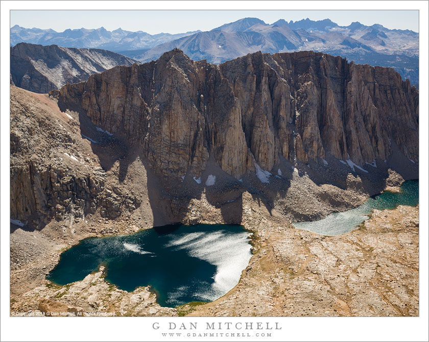
Hitchcock Lakes

High Lakes, Trail Crest
Terrain to the west of Whitney Trail Crest

Hitchcock Lakes from the Mt. Whitney Trail. Sequoia National Park, California. August 11, 2008. © Copyright 2008 G Dan Mitchell – all rights reserved.

Hitchcock Lakes seen from the Mt. Whitney Trail.

I climbed Mount Whitney – again – on August 11, 2008 after crossing the Sierra Nevada from west to east on Sequoia National Park’s High Sierra Trail. I’ve been to the summit a couple times in the past. Last year I swore I would not climb this peak again, mainly because there are so many other beautiful things to see in the Sierra and I didn’t feel a strong need to do this again. But my friends proposed a trip that concluded with the Whitney ascent, and I couldn’t say no.

A traditional starting point for ascents from the west is Guitar Lake, a small – and often somewhat crowded – little lake in a truly alpine setting just above timberline. From here the trail ascends the valley containing these lakes, leading to the junction with the trail from the east side just before reaching the ridge, and then a lateral trail traverses out to the summit of Whitney.

It won’t surprise anyone if I say that there are some wonderful panoramas to be seen from almost any point on this climb. One of my favorite is this view back across the valley from which the trail ascended and towards high elevation Hitchcock Lakes and the ridge between them and the Crabtree Basin beyond.

(Oddly, I often find the summit view to be photographically uninspiring, and I usually end up just making some “record” photos there and a perfunctory pano or two.)


G Dan Mitchell is a California photographer and visual opportunist whose subjects include the Pacific coast, redwood forests, central California oak/grasslands, the Sierra Nevada, California deserts, urban landscapes, night photography, and more.
Blog | About | Flickr | Twitter | FacebookGoogle+ | 500px.com | LinkedIn | Email

Text, photographs, and other media are © Copyright G Dan Mitchell (or others when indicated) and are not in the public domain and may not be used on websites, blogs, or in other media without advance permission from G Dan Mitchell.

Precipice Lake – Imaginary Landscape

Precipice Lake - Imaginary Landscape
Precipice Lake – Imaginary Landscape. Sequoia National Park, California. August 6, 2008. © Copyright G Dan Mitchell – all rights reserved.

A very subjective view of Precipice Lake, Sequoia National Park, California.

Another take on Precipice Lake, this one is not intended to be a literal depiction of the scene. The image has been manipulated in several ways such that it perhaps belongs in the same category with some of my other photos that I describe as “imaginary landscapes.” Part of the “game” with this one was to reduce saturation to the point where it may seem almost but not quite like a black and white image. I like to think of it as being “subjectively true” without being objectively accurate. (Though, frankly, you can say that about essentially any photograph – I suppose this one may just be a bit further from the objective reality that some others I’ve done.)

This photograph is not in the public domain. It may not be used on websites, blogs, or in any other media without explicit advance permission from G Dan Mitchell.

keywords: predicipice, lake, cliff, water, snow, rock, pattern, reflection, kaweah, gap, high, sierra, trail, nevada, california, usa, imaginary, landscape, altered, processed, subjective, ansel adams, sequoia, national park, mountain, alpine, talus, pattern

Evening and Shoreline Trees, Moraine Lake

Evening and Shoreline Trees, Moraine Lake
Evening and Shoreline Trees, Moraine Lake. Sequoia National Park, California. August 7 2008. © Copyright G Dan Mitchell – all rights reserved.

Evening along the tree-lined shore of Moraine Lake in Sequoia National Park, California.

Moraine Lake is located on the Chagoopa Plateau in the Sierra Nevada backcountry of Sequoia National Park, between Big Arroyo and the deep trench of Kern Canyon. Aside from being a bit windy when I’ve been there, it is a very peaceful spot – and a good warm place (relatively speaking) to swim. No surprise given its name, the opposite shore is formed by a lateral moraine that must have come from a glacier traveling down Big Arroyo, and there are lots of rocks everywhere. In fact, along the near shoreline they form a couple of little peninsulas that enclose shallows cut off from the main lake and which support a few trees like those in this photograph.

Most recently I was here in in early August of 2008, when I and a group of friends camped for a night on our trip from Crescent Meadow to Whitney Portal via the High Sierra Trail. Technically (OK, literally), Moraine Lake is not “on” the High Sierra Trail, being instead on a lateral loop that leaves the HS Trail on the Chagoopa Plateau to drop down to the lake, and which then continues to the loop to rejoin a few miles later. Oddly, it seems to me that most people who hike through here probably do take the alternative route past Moraine, with the exception of some hard-core hikers who walk far enough in a day to not need to camp on the Plateau.

keywords: evening, shore, shoreline, trees, moraine, lake, high, sierra, trail, nevada, backpack, hike, camp, clouds, reflection, rock, mountain, alpine, great western divide, peak, forest, grass, quiet, landscape, california, usa, sequoia, national park, stock, blue, sky

High Sierra Trail, Big Arroyo

High Sierra Trail, Big Arroyo
High Sierra Trail, Big Arroyo. Sequoia National Park, California. August 7, 2008. © Copyright G Dan Mitchell – all rights reserved.

The High Sierra Trail crosses a small stream as it begins to climb out of Big Arroyo toward the Chagoopa Plateau.

On this day our route traveled from the old cabin in Big Arroyo out to Moraine Lake on the Chagoopa Plateau. This section of trail was near the start of the day’s walk as we began our climb out of the Arroyo, through a trail section that was often under forest cover and was crossed frequently by small creeks. I’ve been across this trail section more than once, and this time I managed to avoid being surprised by the climb. When you arrive in Big Arroyo from Kaweah Gap the view convinces you that you have nothing but downhill between there and the Kern Canyon – but you are quite wrong. The trail does follow the bottom of the Arroyo for a few miles, but then it climbs – more steadily and more steeply than you might think – up the east side of the valley to reach the flat area of Chagoopa Plateau.

keywords: high, sierra, trail, nevada, california, usa, landscape, travel, hike, backpack, big arroyo, california, usa, climb, ascend, stream, creek, rock, grass, plant, tree, flower, wildflower, big arroyo, chagoopa, plateau, morning, stock, water, rock, boulder