
Tag Archives: valley

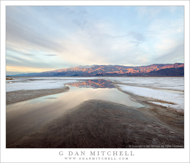
Dawn Light, Panamint Range and Salt Flats

Dawn Light, Panamint Range and Salt Flats

Dawn Light, Panamint Range and Salt Flats. Death Valley National Park, California. February 21, 2011. © Copyright G Dan Mitchell – all rights reserved.

The first dawn light on the snow-dusted Panamint Range is reflected in shallow winter pools on the salt flats of Death Valley National Park.

This is yet another story of serendipity, I think, though it also does involve some advance work – which should please those who become uncomfortable with the idea that not every landscape photograph results from a slow and deliberate and well-planned process! ;-)

The general location of this scene is along a section of salt flat just below the Salt Creek turnoff from the main highway – it is the first area of obvious salt flats that you come to as you head south towards the Furnace Creek area. One one of my first photographic visits to Death Valley I recall stopping near this location along the road and trying to make a photograph pointing down the length of the Valley. It was not successful, but I’ve always been a bit intrigued by this location where the road has to curve around to the east to avoid this salt flat. A day or two earlier on this trip I had stopped along the road at almost this exact location during the “boring light” part of the day after shooting somewhere else. I had wandered – without any camera gear – down across the wash to a patch of brown salt grass and beyond to the edge of the salt flat. I had noticed a lot of things: the very alien nature of this landscape consisting of mud and caked salt and not much else, the surprising presence of some worms and larvae in this tremendously salty water, the fact that the water seemed to seep from beneath the wash, and the interesting shapes that the water created as it slowly spread along the edge of the salt flat.

Move ahead to this morning, the final one of this trip to Death Valley, and I was up well before first light. I had several ideas about what I might photograph, but had not made a firm decision yet since the weather was something of an unknown. I had a vague idea about heading north up the valley and photographing the first light on the hills along its western edge. I was keeping open the possibility that spectacular light might make it worth while to photograph Zabriskie. But I really didn’t know.

I drove to the Furnace Creek/Scotty’s Castle junction and pulled over to watch the light begin to grow. There were lots of clouds! It looked like a lighter area might evolve straight to my east, but I couldn’t quite see photographic potential in it. To the north things looked pretty bleak. There was some possibility that light could happen way to the south, but I wasn’t convinced. I decided to drive a bit south and see what might happen, and very soon I came back to this place where I had stopped earlier. The light wasn’t very promising – clouds to the east seemed likely to block the sunrise light even though there were some interesting cloud patterns overhead that were starting to become more transparent as the sky began to lighten.

Then I caught just a bit of light on some of the higher clouds above the middle level clouds and I started to wonder if the light just might make it through. I went to the back of the car and grabbed my camera with one lens already attached and mounted it on the tripod. I wasn’t sure if I’d want wide or tele for some of the possible subjects, so I grabbed two additional lenses and stuck them in a shoulder bag and headed down the wash, not really looking up too much, just heading straight towards these little areas of water that I remembered from earlier. As I got close to the edge of the flats I saw that, indeed, a band of sunrise light was coming in below the cloud deck to the east (something I have learned to watch for) and starting to light up the highest peaks of the Panamints. I knew that if this light survived long enough to make it down across the range that it was going to happen fast, so I quickly headed out onto the edge of the flats, more or less ignoring the larger scene and simply looking for an interesting reflecting pool. As I set up – working very quickly now – the first sun lit up the face of the panamints and revealed radiating cloud shapes above. I had perhaps two minutes of this light… and then the small gap along the eastern horizon must have closed up as the light disappeared and went back to gray.

G Dan Mitchell Photography | Flickr | Twitter | Facebook | Email
Text, photographs, and other media are © Copyright G Dan Mitchell (or others when indicated) and are not in the public domain and may not be used on websites, blogs, or in other media without advance permission from G Dan Mitchell.
Dunes, Cottonwood Mountains, and Dust Storm

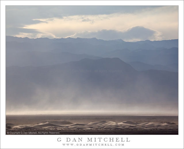
Dunes, Cottonwood Mountains, and Dust Storm

Dunes, Cottonwood Mountains, and Dust Storm. Death Valley National Park, California. February 19, 2011. © Copyright G Dan Mitchell – all rights reserved.

Afternoon winds whip up a dust storm over Death Valley between sand dunes and the high ridges of the Cottonwood Mountains.

Following my typical routine of “get up ridiculously early and shoot until I can’t stand it any longer, hang out during the middle of the day, and then head out for late afternoon and evening shooting,” I had been watching some interesting clouds developing far to the north of Stovepipe Wells during the day and decided that I might head up that way in the evening if they continued to hold promise. After crossing the Valley to the Scotty’s Castle road junction I could see a curtain of virga falling from those clouds to the north, so I decided to head that way.

The wind had been picking up from the south during the afternoon as another weather front approached. As I headed up along the edge of the main valley I could see that this wind was starting to pick up dust and sand from the Mesquite Dunes area near Stovepipe and from areas just north of that. I’m more familiar with the dust being carried south by winds out of the north, so this was a bit of a different site as sand/dust were being picked up from the dunes rather than being deposited there.

The dunes at the bottom of this photograph are not the familiar “main” dunes near Stovepipe, but are instead smaller dunes running north/south up the Valley. While a larger version of the photograph shows some blowing dust on these foreground dunes, the main cloud is coming from further south down the Valley. Beyond the dust and across the Valley are the hills of the Cottonwood range ascending to a ridge that still holds a bit of snow from storms over the previous couple of days, with building clouds above that would bring another dusting on this evening.

G Dan Mitchell Photography | Flickr | Twitter | Facebook | Email
Text, photographs, and other media are © Copyright G Dan Mitchell (or others when indicated) and are not in the public domain and may not be used on websites, blogs, or in other media without advance permission from G Dan Mitchell.
Winter Evening Sky, Panamint Range, Death Valley

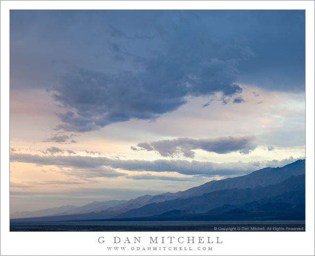
Winter Evening Sky, Panamint Range, Death Valley

Winter Evening Sky, Panamint Range, Death Valley. Death Valley National Park, California. February 18, 2011. © Copyright G Dan Mitchell – all rights reserved.

Winter clouds fill the evening sky above the eastern slopes of the Panamint Range in Death Valley National Park.

After the long drive from the San Francisco Bay Area I arrived at Stovepipe Wells in Death Valley and set up my camp in the mid afternoon and hung out a bit, thinking about the prospects of late afternoon and evening shooting. Because a weather front was coming in (the forecast called for a chance of rain in the Valley and pretty much certain light snow over the passes) the clouds were increasing, in many directions heading past the point of “picturesque” and more towards “socked in.” I was hoping for some evening light – or early rain? – but it seemed less promising as evening approached. In circumstances like these I may come up with a few possible shooting alternatives ahead of time, watch as conditions develop, and make a last-minute decision about where to go based on observations and hunches.

So, late in the afternoon I stopped near Death Valley Dunes and worked to line up some long shots that filled the background of the dunes with the rugged shapes of the Grapevine Mountains, and then headed towards the junction with the road to Scotty’s Castle to try to figure out if the light held more promise to the north or the south. It didn’t look totally promising in either direction, but I thought that I might be able to make something out of the haze to the south as the ridges on both sides of the Valley receded, especially if a bit of glow in the sky turned up right at sunset. So, south it was.

I drove just a little ways in that direction to a point where the road curves a bit towards the east to travel around the northernmost area of salt flats in what I think of as the lower valley – this is the area a bit south of the Salt Creek cutoff. From here there is a fairly open view all the way down to the end of the Valley, and it looked like the clouds were going to evolve in some interesting ways. It didn’t look like I would see a gaudy, brilliantly colorful sunset, but something more subtle and quiet looked like it might happen. As the light began to fade I made a series of photographs whose subject was largely the sky and the atmospheric recession along the Panamint Range (shown here) on the west side of the Valley and the mountains just beyond Furnace Creek.

G Dan Mitchell Photography | Flickr | Twitter | Facebook | Email
Text, photographs, and other media are © Copyright G Dan Mitchell (or others when indicated) and are not in the public domain and may not be used on websites, blogs, or in other media without advance permission from G Dan Mitchell.

Horsetail Fall – It’s That Time Again

UPDATE: As of 2020 I am no longer posting annual updates concerning this subject — and I am editing older posts on the subject in light of the need to be more responsible about not encouraging the onslaught. I also no longer recommend going to the Valley to see it. Unfortunately, too much exposure (yes, I played a part in it, unfortunately) has led to absurd crowds, traffic jams, littering, destruction of areas in the Valley where too many people go to see it… and the park has increasingly — and appropriately — cracked down. Parking options have been eliminated, at least one viewing location has been closed. Good news! The rest of Yosemite Valley is still there and often exceptionally beautiful at this time of year.

As more and more people now seem to know, late February is the prime time for the appearance of the “natural fire fall” in Yosemite Valley, when the setting sun may strike Horsetail Fall near the east end of the face of El Capitan, and when viewed from the right angle create a striking light show. I do not plan to be there to photograph the event this year since I’ll likely be shooting somewhere else during the prime time for the fall… and I no longer encourage others to attempt it. I’ll explain below.

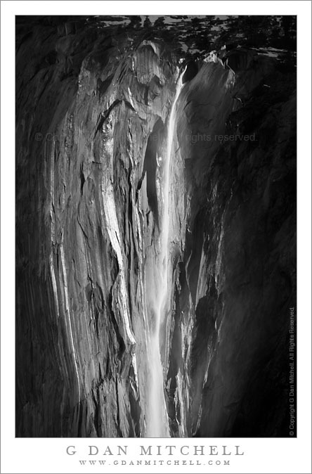
Horsetail Fall, Early Evening

(Photo: Horsetail Fall, Early Evening. Yosemite Valley, California. February 15, 2010. © Copyright G Dan Mitchell – all rights reserved.)

The spectacle of Horsetail Fall is now quite well known. The initial renown came after Galen Rowell produced a striking and now-famous photograph of it several decades ago. Eventually others began to photograph it as well. (I read somewhere that several other well-known photographers made images of Horsetail decades earlier, but apparently no one “discovered” the special annual sunset light until Rowell shot it.) Since that time, and especially in the past few years, news of the phenomenon and information about when, where, and how to shoot it has become widespread – especially now that information travels so fast on the Internet. As of this article revision, a plethora of articles (newspapers, magazines, the web) and social media posts have built the thing up beyond all reason, with predictable and unfortunate results.

Twice each year, the setting sun lines up just right so that it casts its final light directly on this waterfall for a few weeks. The phenomenon is ephemeral and dependent on a series of conditions that must all occur at the right time. First, it must be during that short window of time when the setting sun strikes the location of the fall on a high cliff. Second, the waterfall must be flowing. Typically this means that there has been a good amount of snow followed by a warm-up that melts enough of it to get the fall going, though a warm winter rain could accomplish the same thing. Third, the western horizon must be clear so that the sun’s light will not be obstructed as it sets. (Those who have tried to shoot the fall a few times may have experienced disappointment when a crescendo of light potential occurs late in the day… only to be suddenly switched off as the sun drops behind low clouds to the west. To be honest, this happens more often than not.)

The photographer wants where light hits the fall more or less from behind. The number of suitable locations is quite limited and — no surprise — they end up being hugely crowded.

Having said all of this, be aware that it is going to be extremely difficult to get a photograph of Horsetail that hasn’t already been done. I’ve seen a few,  but most essentially duplicate existing images. In some ways, I think that contemplating the fact that such a thing actually happens in a place that already contains as many marvels as we see in the Valley may be more rewarding than making another photograph of it.

A downside to the experience is that the popularity of “bagging this shot” has taken off remarkably in the past few years. Yosemite Valley is obviously already a place where it is tempting to run from well known spot to well known spot trying to recreate the well known photographic images that others have produced there. (Ironically, those who take this approach often miss many, many less known subjects in the Valley that can be every bit as beautiful and rewarding.) With Horsetail, the rush of photographers is compressed into a very short time period and focused on a few (mostly only two!) very popular shooting locations. Those who shoot from them on prime evenings may arrive in the morning to reserve a spot… to find a crowd of photographers is already set up.

As of the date of this revision in 2020 the situation has become quite insane, and the park service has had to take serious steps to control the mess. Literally thousands of photographers and others have been arriving in places that used to handle a dozen or two folks. Traffic jams ensued, the experience has been significantly degraded, parking is a mess, and the crowds are damaging park features. As of this year large sections of park roads are now off-limits to parking and one of the two popular locations has been completely closed.

I strongly urge you to NOT go.

I was fortunate a few years ago to have a nearly solitary experience photographing the fall. That winter Northside Drive was closed and all traffic was routed in and out of the Valley along Southside Drive. It had snowed, and one of the locations for photographing the fall was only accessible by hiking across the Valley in snow to Northside Drive and then walking a bit further in the snow to the place from which I shot. I walked over early and spent an hour or more shooting alone in the silent and snow-covered El Capitan meadow! Then, as sunset approached, I walked quietly to a place where I could see the fall and joined a small handful of fellow photographers waiting for the event. We weren’t disappointed.

That is the way I want to remember photographing Horsetail Fall.

(Some of my Horsetail photographs are found here.)

G Dan Mitchell Photography | Flickr | Twitter | Facebook | Email
Text, photographs, and other media are © Copyright G Dan Mitchell (or others when indicated) and are not in the public domain and may not be used on websites, blogs, or in other media without advance permission from G Dan Mitchell.