Tag Archives: camp

Forest in Reflected Light, Kern River

Forest in Reflected Light, Kern River
Forest in Reflected Light, Kern River. Sequoia National Park, California. August 9, 2008. © Copyright G Dan Mitchell – all rights reserved.

In the middle of my August 2008 trans-Sierra backpack trip we spent a morning walking up the 7.5 miles between Kern Hot Springs and Junction Meadow in the upper Kern Canyon. Since I’m fond of higher country I wasn’t expecting too much on this day, but I was happy to encounter a wonderful lighting situation that I’ve seen before in Yosemite and similar valleys: the western canyon walls were in full sunlight and reflecting beautiful, warm, diffuse light across the river into the shaded forest on the east side where I photographed these trees and ferns.

keywords: kern, river, valley, forest, tree, fern, branch, rock, trunk, red, morning, nature, landscape, sequoia, national park, california, usa, trail, hike, backpack, camp, high, sierra, nevada, mountain, range, stock

Ascending to Kaweah Gap

Ascending to Kaweah Gap

Ascending to Kaweah Gap. Sequoia National Park. August 6, 2008. © Copyright 2008 G Dan Mitchell – all rights reserved.

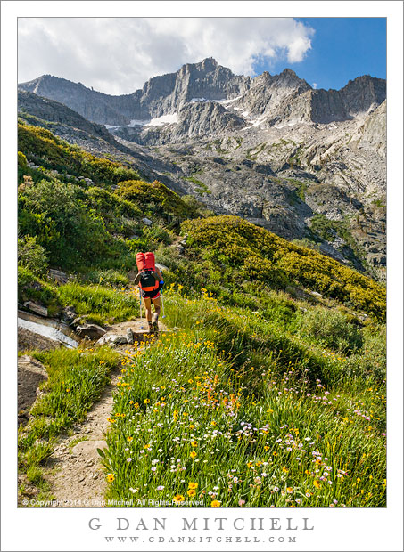
My friend Caroline ascends the High Sierra Trail toward Kaweah Gap above Upper Hamilton Lake in Sequoia National Park, California on the morning of the third day of a 9-day trans-Sierra pack trip from Crescent Meadow to Whitney Portal.

The High Sierra Trail crosses the entire range between Crescent Meadow in the west and Whitney Portal in the east, and travels through Sequoia National Park with the exception of the section to the east of Whitney Trail Crest. This portion above Upper Hamilton Lake ascends about 2500′ rather steeply to Kaweah Gap, a beautiful pass over the Great Western Divide by which the trail reaches Big Arroyo and the Kern River drainage.

In this photo Caroline has finished most of the very steep initial ascent above Hamilton Lake and is crossing an area of many streams and meadows and flowers shortly before arriving at Precipice Lake, from which it is only a short distance to the Gap.


G Dan Mitchell is a California photographer and visual opportunist whose subjects include the Pacific coast, redwood forests, central California oak/grasslands, the Sierra Nevada, California deserts, urban landscapes, night photography, and more.
Blog | About | Flickr | Twitter | FacebookGoogle+ | 500px.com | LinkedIn | Email

Text, photographs, and other media are © Copyright G Dan Mitchell (or others when indicated) and are not in the public domain and may not be used on websites, blogs, or in other media without advance permission from G Dan Mitchell.

Dawn and Shoreline Trees, Moraine Lake

Dawn and Shoreline Trees, Moraine Lake
Dawn and Shoreline Trees, Moraine Lake. Sequoia National Park, California. August 8, 2008. © Copyright G Dan Mitchell – all rights reserved.

Dawn along the tree-lined shore of Moraine Lake in Sequoia National Park, California. Moraine Lake is along the “High Sierra Trail” route between Crescent Meadow in the western Sierra and Whitney Portal on the east side of the range. This photograph was made last week as I crossed the range from west to east with a group of friends – who were all still warm in their sleeping bags while I arose before dawn to prowl the lakeshore and get this sunrise photograph.

keywords: dawn, shore, shoreline, trees, moraine, lake, high, sierra, trail, nevada, backpack, hike, camp, reflection, rock, mountain, alpine, great western divide, peak, forest, grass, quiet, landscape, california, usa, sequoia, national park, stock, blue, sky

Between Ireland and Townsley Lakes

PlateauTarn2005|08|27: Tarn between Ireland and Townsley Lakes. Yosemite National Park. August 27, 2005. &copy: Copyright G Dan Mitchell.

Tarn between Ireland and Townsley Lakes. Yosemite National Park. August 27, 2005. © Copyright G Dan Mitchell – all rights reserved.

This small tarn is located on a cross-country route* over a low ridge between Ireland and Townsley Lakes in Yosemite’s backcountry above Tuolumne Meadows. The plateau where this lake is located is one of may favorite parts of the park, and I visit it at least once each summer.

*For those wondering about the route: There is no trail between Townsley and Ireland Lakes, so you should only go here if you are comfortable with trail-less travel and have some experience with this. If you don’t, I’ll just point out that people have gotten lost and into other kinds of unfortunate trouble in places even more benign than this one. Please only regard this as a personal story and not as encouragement to travel here nor as a route guide.

That said, I often make my way to Townsley Lake from Fletcher Lake by any of the common routes and the many available variations, some of which almost look like faint trails. I like to either ascend the grassy slopes above (to the right when approaching from Fletcher) Townsley directly from the lake or else bypass the lake and head straight for the upper part of this slope. From the top of this slope a large alpine tundra area dotted by a few small tarns appears before me. I take a route that heads generally toward the left side of an apparent cone-shaped prominence on the ridge between me and Ireland Lake – there are many ways to get there and I don’t always follow the same route. Eventually I cross over some steep slabs to top out on this ridge, from which I pick out a reasonable route down to the trail coming up toward Ireland Lake from the left.

keywords: tarn, pond, townsley, fletcher, lake, ireland, mountain, ridge, meadow, rock, creek, alpine, sierra, nevada, yosemite, national park, backpack, hike, camp, cross country, landscape, scenic, stock