
Tag Archives: desert

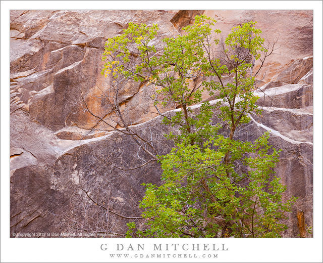
Slot Canyon Tree

Slot Canyon Tree - A box elder tree stands against the vertical sandstone walls of a Utah slot canyon
A box elder tree stands against the vertical sandstone walls of a Utah slot canyon

Slot Canyon Tree. Grand Staircase-Escalante National Monument, Utah. October 23, 2012. © Copyright 2012 G Dan Mitchell – all rights reserved.

A box elder tree stands against the vertical sandstone walls of a Utah slot canyon

Near the beginning of this late-October photographic trip in Utah, we visited a long canyon, slot-like in places, in the southern reaches of Utah in the Grand Staircase-Escalante National Monument. Although I had been is small sections of little slot canyons before, this was actually the first time I ventured up a desert canyon like this one (with the exception of some in Death Vally) that had a creek running up the bottom, steep sandstone walls, and plenty of cottonwoods, box elders, and other typical plants. We started in a more or less flat area outside the canyon, waded up a section of the creek to enter the canyon, and spent the next few hours exploring and making photographs.

I have a thing about trees standing in front of rock walls, and among the mental images I was carrying as we went to the Southwest were several with that theme. I was actually thinking more about trees with fall colors, but in this particular canyon there was a still a lot of green foliage – and I liked the somewhat unusual combination of the leaves’ lime green and the pinkish, almost purple coloration of the rock in the soft reflected canyon light.

G Dan Mitchell is a California photographer and visual opportunist whose subjects include the Pacific coast, redwood forests, central California oak/grasslands, the Sierra Nevada, California deserts, urban landscapes, night photography, and more.
Blog | About | Flickr | Twitter | Facebook | Google+ | 500px.com | LinkedIn | Email

Text, photographs, and other media are © Copyright G Dan Mitchell (or others when indicated) and are not in the public domain and may not be used on websites, blogs, or in other media without advance permission from G Dan Mitchell.

Desert Wash and Mesa

Desert Wash and Mesa

Desert Wash and Mesa. Capitol Reef National Park, Utah. October 8, 2012. © Copyright 2013 G Dan Mitchell – all rights reserved.

Sandstone formations and mesa tower beyond a desert wash, Capitol Reef National Park

It has been a while since I’ve posted more of the late 2012 Utah photographs I made during fall visits, but there are more. Actually, there are quite a few more! The time I spent in that state in 2012 was photographically very productive, and I look forward to returning before too long.

I think I might categorize this as one of those “you can find a photograph almost anywhere if you keep your eyes open” photographs, since it was made it a location that is probably not regarded as being as special as some others nearby. Driving from Torrey, Utah toward Capitol Reef National Park, there is quite a bit to see. Off to the right in places there are deep and rugged canyons with lots of trees among the red rocks. To the left runs a large series of red rock cliffs that lead up toward the park. As we drove on this afternoon, the light was softened a bit by clouds and there was a kind of glow on the red rock terrain. So we simply pulled off to the side of the road as we crossed this wash and I composed a photo looking back past the foreground plants and across the wash toward the rising cliffs beyond.

G Dan Mitchell is a California photographer and visual opportunist whose subjects include the Pacific coast, redwood forests, central California oak/grasslands, the Sierra Nevada, California deserts, urban landscapes, night photography, and more.
Blog | About | Flickr | Twitter | Facebook | Google+ | 500px.com | LinkedIn | Email

Text, photographs, and other media are © Copyright G Dan Mitchell (or others when indicated) and are not in the public domain and may not be used on websites, blogs, or in other media without advance permission from G Dan Mitchell.
Salt Flats and Waterways

Salt Flats and Waterways

Salt Flats and Waterways. Death Valley National Park, California. March 30, 2011. © Copyright 2013 G Dan Mitchell – all rights reserved.

Seasonal creeks twist though salt flats of Death Valley, Death Valley National Park, California

Since I have recently posted a few other photograph from this same location and with some of the same commentary that I might include here, I’ll try to keep this description a bit short. The photograph was made from the top of Dantes View, the Death Valley observation point that is about a mile above the lowest part of the Valley near Badwater. The panorama from Dantes View almost overwhelmingly expansive, so on this visit I though that rather than just trying to photograph that immensity, I would also use a long focal length lens to try to isolate and pick out some smaller portions of the overall scene.

This photograph shows a section of the salt flats, surrounded by browner areas that include more gravel. A darker foreground area that runs along the road is visible at the bottom of the photograph, and the upper corner includes the area where the West Side Drive runs between the flats and the lower slopes of the Panamint Range. The many waterways crossing the flats and then converging on the salt area are evidence of the role water plays in the creation of this barren terrain.

G Dan Mitchell is a California photographer and visual opportunist whose subjects include the Pacific coast, redwood forests, central California oak/grasslands, the Sierra Nevada, California deserts, urban landscapes, night photography, and more.
Blog | About | Flickr | Twitter | Facebook | Google+ | 500px.com | LinkedIn | Email

Text, photographs, and other media are © Copyright G Dan Mitchell (or others when indicated) and are not in the public domain and may not be used on websites, blogs, or in other media without advance permission from G Dan Mitchell.

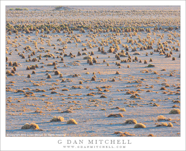
Devil’s Cornfield

Devil's Cornfield
Devil’s Cornfield

Devil’s Cornfield. Death Valley National Park, California. March 31, 2011. © Copyright 2013 G Dan Mitchell – all rights reserved.

Early morning light slants across the arrow weed plants of the Devil’s Cornfield area of Death Valley National Park

For the record, while I have no evidence either way regarding the role of the devil in creating this terrain, there is definitely no corn growing in this field! The plant is known as “arrowweed” (or arroweed or arrow weed), and the tall shapes are apparently formed as the sand erodes from around the roots.

This spot is one of several in Death Valley that have been hard for me to see as photographs. (Other “challenges” include the Devil’s Golf Course – which mostly looks like crusty, dried mud to me – and Salt Creek – which I’ve mostly visited at the times of day when the light hasn’t been idea.) I came close once before with a closer view of the plants that revealed their actual color a bit more and which placed them in front of a backdrop of more distant barren mountains. This photograph certainly doesn’t provide a strong center of visual interest, but I like the sense of the plants leading off into the distance, the angles of the blue shadows, and the contrasting warm colors of the plants in near golden-hour light.

G Dan Mitchell is a California photographer and visual opportunist whose subjects include the Pacific coast, redwood forests, central California oak/grasslands, the Sierra Nevada, California deserts, urban landscapes, night photography, and more.
Blog | About | Flickr | Twitter | Facebook | Google+ | 500px.com | LinkedIn | Email

Text, photographs, and other media are © Copyright G Dan Mitchell (or others when indicated) and are not in the public domain and may not be used on websites, blogs, or in other media without advance permission from G Dan Mitchell.