
Tag Archives: dome

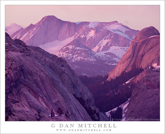
Alpenglow, Mount Conness

Alpenglow, Mount Conness

Alpenglow, Mount Conness. Yosemite National Park, California. June 18, 2011. © Copyright G Dan Mitchell – all rights reserved.

The last evening light illuminates domes near Tenaya Lake and the summit of Mount Conness with briilliantly colorful alpenglow, Yosemite National Park.

The tall peak at upper left is the summit of Mount Conness, one of the highest peaks in Yosemite National Park. The peak is located on the park boundary and the Sierra Nevada crest a bit north of Tioga Pass, and is visible from many places in the Tuolumne/Tioga high country. It is also a popular destination for peak baggers. The left foreground granite dome is the lower face of Polly Dome, which drops to the shoreline of Tenaya Lake. The left slope of Pywiak dome is visible in the shadows at lower right and beyond is the more brightly illuminated Medlicott dome.

I forgive you if you don’t believe the colors that you see in this photograph. I barely believe them myself, and I was (obviously!) there for the show. What happened on this evening was a near perfect example of a light phenomenon that Sierra photographers watch for and are occasionally lucky enough to experience. I have learned to see the signs that indicate that this light is possible, but also to understand that even when the conditions offer this potential that they rarely deliver.

On certain cloudy evenings in the Sierra it appears that there will be no sunset color – everything is hazy and drab and washed out. But if things play out just right, this very set of drab conditions (that induce some photographers to put away their gear too soon!) can produce some of the most striking and intense color possible if a few things fall into place just right. On this evening I had stopped for a moment at Olmsted Point, thinking to photograph ice-covered Tenaya Lake with a long lens and including the mass of Mount Conness in the distance. When I arrived there, things were about as unpromising as they could possibly be. A dull, greenish-blue haze hung in the air, overcast washed out the light, and Conness was obscured by clouds. I had actually put my gear back in the car when I looked back up and noticed that the summit of Conness had briefly poked through the clouds, accentuating its bulk and the sense that it towered over the foreground mountains. The light was still awful (I have the photos to prove it! ;-) but I thought I’d see if I could get something with the peak emerging from its shroud.

But still nothing much happened. I turned the camera to photograph some nearby trees and a blackbird that was looking for snacks. Then I noticed that there was some brighter light to the southwest and I began to consider the possibility that the cloud cover might end a bit to the west – and that is requirement #1 for the light conditions I’m describing. If the cloud deck ends to the west, as the sun reaches the horizon it may briefly break under the clouds and send brilliantly colorful light up into the clouds in the Sierra from below, creating a miles-wide light panel of the most astonishing colors. But still, it was hazy and the peaks were shrouded in clouds. But then I noticed that the clouds around Conness were beginning to drift off to the east and thin a bit. I mentioned (knock on wood!) to one of the other photographers that there was a possibility of “miracle light,” but that I wasn’t making any promises!

Then the thinning clouds began to pick up a slight pink tinge and the left side of Conness began to get some light directly from the west. Then, within a minute or so, the colors went absolutely crazy. People around me were audibly gasping as the color changed. At one point several of us spontaneously looked up to the west when we noticed the light suddenly increase out of the corners of our eyes. At the same time, the clouds almost completely dissipated from the area around the peak and because the whole sky was filled with brilliantly colorful clouds, this light began to suffuse even the depths of the canyon and slopes facing away from the sunset with this amazing light.

Never put your camera away until the last light is gone. :-)

G Dan Mitchell Photography | Flickr | Twitter (follow me) | Facebook (“Like” my page) | LinkedIn | Email
Text, photographs, and other media are © Copyright G Dan Mitchell (or others when indicated) and are not in the public domain and may not be used on websites, blogs, or in other media without advance permission from G Dan Mitchell.
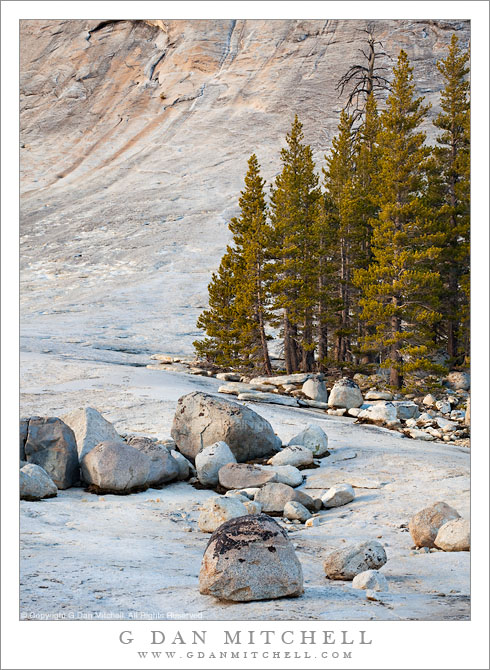
Glacial Erratics and Trees, Lembert Dome

Glacial Erratics and Trees, Lembert Dome

Glacial Erratics and Trees, Lembert Dome. Yosemite National Park, California. June 5, 2010. a© Copyright G Dan Mitchell – all rights reserved.

Glacial erratics and trees at the base of Lembert Dome, Tuolumne Meadows, Yosemite National Park.

This photograph was made last spring in early June, when I drove over Tioga Pass on a quick one-day jaunt right around the time that the road was re-opened for the season after its annual winter closure. The road opened a bit later than usual in 2010 due to above average and late snow fall, and when I crossed there was as much or more snow than I recall seeing up there.

This was one of my marathon drive days. I started well before dawn in the San Francisco Bay Area and arrived in Yosemite in the very early morning and without any concrete plan – except that the ideas of visiting waterfalls and possibly getting up to Tioga Pass were on my mind. I did stop near the Valley first, where I made a series of photographs of Cascade Creek in virtually full flow. After doing this and making a very brief visit to the Valley, I decided to visit the high country along Tioga Pass road. I went just over the pass before turning back. There was so much snow still around that in most places it still looked much more like winter than like early June.

I finally started heading back to the west, as my plan was to return late to the SF Bay Area. As I left the pass and started down toward Tuolumne Meadows the light began to get “interesting” as the sun dropped lower in the west and some high clouds occasionally softened the light. As I drove past Lembert Dome I thought of photographing these glacial erratics that sit on the apron at the bottom of the dome before making one last stop to photograph snow-covered Tuolumne Meadow in the day’s last light.

G Dan Mitchell Photography | Flickr | Twitter | Facebook | Email
Text, photographs, and other media are © Copyright G Dan Mitchell (or others when indicated) and are not in the public domain and may not be used on websites, blogs, or in other media without advance permission from G Dan Mitchell.
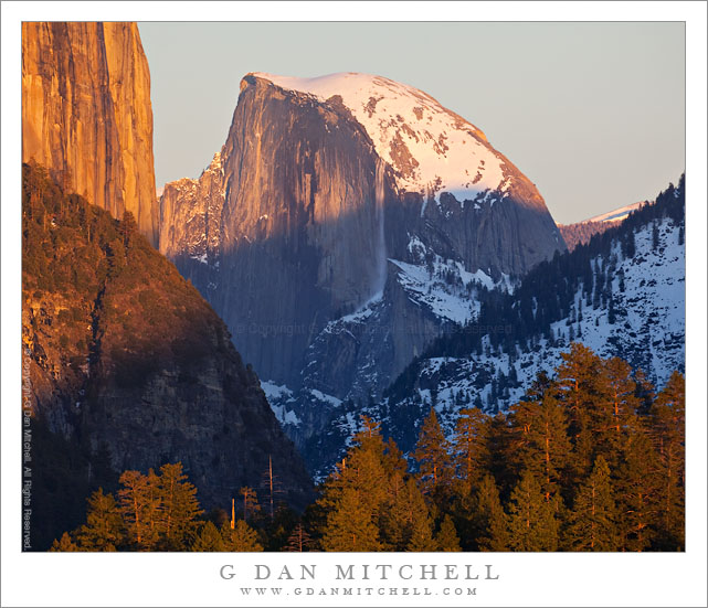
Sunset Avalanche, Half Dome

Sunset Avalanche, Half Dome

Sunset Avalanche, Half Dome. Yosemite National Park, California. January 16, 2011. © Copyright G Dan Mitchell – all rights reserved.

An avalanche breaks loose from the edge of Half Dome as sunset light falls over Yosemite Valley.

Sometimes timing is everything. But, to be honest, luck often plays a bigger part! :-)

On my way out of The Valley on a mid-January weekend, I made this spot my last stop, thinking that I wanted a photograph from this angle at sunset with snow on Half Dome. (I have a number of photographs of this location, but mostly from the warmer months of the year. ) I know this spot well enough at this point that I know pretty much exactly where to be and when to be there, and this was no exception. On the way up here I first stopped to photograph some trees on a ridge across the Valley, something I worked on more than once during this trip. When the last light left those trees I headed on up the road to this overlook and arrived perhaps a full half hour before the start of the real light show. I hung out a bit, ate a snack, and eventually set up.

I never know exactly what will happen here, believe it or not, even though I understand the process pretty well. The foreground right ridge first falls into shadow, then the shadow line begins to creep up toward the face of Half Dome and rise up the rocky slope in front of El Capitan at the left. But what the sky will do during this transition is quite variable. Sometimes the sunset simply dies out with a whimper. On other evenings the light goes through a remarkable sequence of transitions. That is what finally happened on this evening. Eventually I’ll share some of the other photographs from this evening, but for now I’ll just share a hint or two. The color of the sky behind Half Dome transitioned from blue to pink and purple and finally to a deep blue that verged on purple.

But the real surprise – and one I did not realize I had captured it until I got home and looked closely at my raw files – was that one of the images contained a sort of “Yosemite Fall” that I had never seen before, namely the “snow fall” created as a large piece of the snow field near the edge of Half Dome let loose after a day of warm sun and cascaded down the right face of the mountain… just as sunset light split the dome! I suppose this provides yet another opportunity to quote Ansel, who apparently once said, “Sometimes I do get to places just when God’s ready to have somebody click the shutter.”

This photograph is not in the public domain and may not be used on websites, blogs, or in other media without advance permission from G Dan Mitchell.

G Dan Mitchell Photography
FlickrTwitter (follow me) | Facebook (“Like” my page) | LinkedInEmail

Text, photographs, and other media are © Copyright G Dan Mitchell (or others when indicated) and are not in the public domain and may not be used on websites, blogs, or in other media without advance permission from G Dan Mitchell.


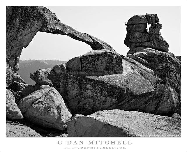
Natural Arch, Sierra Nevada

Natural Arch, Yosemite

Natural Arch, Sierra Nevada, California. July 23, 2010. © Copyright G Dan Mitchell – all rights reserved.

One of two known natural arches in this area stands high on a ridge.

Although I have visited this area for decades and know it quite well, this year was the first time I had taken notice of and actually visited this natural arch or bridge, supposedly one of two in this region. (The other is, from what I’ve heard, underwater!) I won’t say too much more about this feature since it seems to be pleasantly unburdened by tremendous waves of tourists at this point… If you know where it is, I urge you to do the same.

(To illustrate how important this is with a fragile feature such as this arch, after I posted this image somewhere else a person followed up with a photograph of some damned fool standing on the arch! This demonstrates a gross disregard for this beautiful feature – there are weaknesses in the rock at the ends of the arch, and taking risks with a feature like this one that took nature thousands of years to construct is the height of irresponsibility.)

This photograph is not in the public domain and may not be used on websites, blogs, or in other media without advance permission from G Dan Mitchell.

G Dan Mitchell Photography
About | Flickr | Twitter | Facebook | Google+ | 500px.com | LinkedIn | Email

Text, photographs, and other media are © Copyright G Dan Mitchell (or others when indicated) and are not in the public domain and may not be used on websites, blogs, or in other media without advance permission from G Dan Mitchell.

(Basic EXIF data is available by “mousing over” large images in blog posts. Leave a comment if you want to know more.)