Tag Archives: fire

About the Yosemite “Rim” fire… and more

UPDATE and a NOTE:

Update: Shortly after I posted this, my reports on highway 120 through the park via the Tuolumne Meadows area  were rendered incorrect/outdated by way of an updated announcement from the park service as follows:

“Beginning at 12:00pm on Wednesday, August 28th, Tuolumne Meadows and the High Sierra will only be accessible via Highway 120 East through Lee Vining.  The Tioga Rd/Hwy 120 East will be temporarily closed between White Wolf Lodge and the Big Oak Flat Rd./Hwy 120 West at Crane Flat; the closure is estimated to be 3 to 4 days.  Tuolumne Meadows Lodge, the High Sierra Camps, and Tuolumne Meadows and Porcupine Flat campgrounds all remain open.”

Basically, this means that you will not be able to use highway 120 as a route across the Sierra until further notice. I’m not surprised – in fact, I’ve been somewhat surprised that the road remained open this long. Apparently the following URL is also a good source of updates from the park: http://www.yosemitepark.com/yosemite-fire-update.aspx

Note: All of which brings me back to my original statement that I don’t have inside information on this fire, and that anyone traveling to the area needs to check official sources for conditions updates. I will likely not update this page as things change, so the information posted here should be regarded as potentially being out of date!

My original post follows…

A few people have asked me for information about the “Rim” fire which started not far from Groveland near highway 120, and which is currently burning along the northwest boundary of Yosemite National Park, generally moving east and north toward the highway 108 area. While I know much of this area fairly well from many years (decades, actually) of visits, I do not have any inside information about the fire itself, nor am I an expert on wildfires. One good source of (limited but objective) information is the Stanislaus National Forest Rim Fire Incident web page. A map on this page is a quite amazing source of information, especially when combined with some familiarity with the area and a reading of various written reports. (The version on the main page seems to be based on Google Maps, and allows you to scroll around and zoom in.) Lots of folks who live and work in the area are sharing updates on the usual social media sites. The Mariposa Gazette is another local news source.

The fire started on August 17 more or less midway between Groveland and the  northwest park entrance and not far off of the highway 120 corridor near the Rim of the World area overlooking the canyon of the Tuolumne River. (Highway 120 is a common route for entry to the park from the west and northwest, and it connects via Tuolumne Meadows and Tioga Pass to the east side of the Sierra at the town of Lee Vining.) The spread of the fire at first was somewhat quick, which is no surprise given the extremely dry conditions in the Sierra following a second very dry winter and almost no real precipitation since late 2012. Then, between about August 20 and 23, the fire exploded, expanding  very quickly to cover a huge area generally to the east and north of the starting point, with the fire generally racing northeast but also spreading to the north and south. Continue reading About the Yosemite “Rim” fire… and more

Wildfire Survivors, Morning

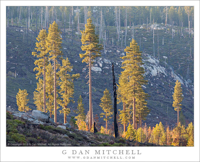
Wildfire Survivors, Morning

Wildfire Survivors, Morning. Yosemite National Park, California. May 12, 2013. © Copyright 2013 G Dan Mitchell – all rights reserved.

Morning light on tall trees spared by a wildfire, Yosemite National Park

This is a sort of sad but hopeful portion of Yosemite. This valley, along the Tioga Pass Road, was badly burned back in the 1990s in a fire that burned upslope from the Foresta area and through old forest than had not burned in a long time. Back in the days of fire suppression, during the decades without fire a lot of undergrowth grew up and many fallen trees and other sorts of flammable debris collected. The result of Smokey Bear’s call to “prevent forest fires” was the creation of a very fuel rich forest environment and produced super-fires that were so hot that they not only consumed undergrowth but killed mature trees. This fire was one of those, and the forest in this valley near the upper reaches of the fire, just before it was halted at Tioga Pass Road, was almost completely decimated.

At first I found the sight to be depressing. Gradually I have come to regard fire as a normal part of forest ecology and can now see some stark beauty in its aftermath. However, this valley has remained a scar and a blunt reminder of why managing natural fires, along with other measures, makes for a better strategy. After a few years I began to think that there might be a photograph in this valley, though I stopped for several years without seeing anything that would work. I began to think that it might be good to try to photograph late in the day when area is open to the evening sky in the west – but I stopped a number of times and it just wasn’t right. However, on this trip I passed by early in the morning, just as the sun was topping a ridge to the east (left) and lighting up this small group of older trees that survived the original fire and now form a little outpost of forest against the desolate face of the far hillside.

G Dan Mitchell is a California photographer and visual opportunist whose subjects include the Pacific coast, redwood forests, central California oak/grasslands, the Sierra Nevada, California deserts, urban landscapes, night photography, and more.
Blog | About | Flickr | Twitter | FacebookGoogle+ | 500px.com | LinkedIn | Email

Text, photographs, and other media are © Copyright G Dan Mitchell (or others when indicated) and are not in the public domain and may not be used on websites, blogs, or in other media without advance permission from G Dan Mitchell.

The Annual Horsetail Fall Post

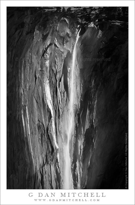
Horsetail Fall, Early Evening

UPDATE: As of 2020 I am no longer posting annual updates concerning this subject — and I am editing older posts on the subject in light of the need to be more responsible about not encouraging the onslaught. I also no longer recommend going to the Valley to see it. Unfortunately, too much exposure (yes, I played a part in it, unfortunately) has led to absurd crowds, traffic jams, littering, destruction of areas in the Valley where too many people go to see it… and the park has increasingly — and appropriately — cracked down. Parking options have been eliminated, at least one viewing location has been closed. Good news! The rest of Yosemite Valley is still there and often exceptionally beautiful at this time of year.

Horsetail Fall, Early Evening. Yosemite Valley, California. February 15, 2010. © Copyright G Dan Mitchell – all rights reserved.

The silver strand of Horsetail Fall and water reflecting on surrounding cliffs in late afternoon light, Yosemite Valley, California.

Although it seems like it would be extremely difficult to make a truly original photograph of Horsetail Fall at this point, I won’t completely rule out the possibility, and recently I have seen a few interesting and imaginative photographs of the phenomenon.

The necessary conditions are fairly specific, and even when the basics are in place there is no guarantee that the show will occur on a given evening. To be honest, the odds are distinctly against you, and you are more likely to see something that doesn’t match your expectations.

  • There must be flowing water in the creek near the east end of the face of El Capitan that feeds the fall. This is not a sure thing in mid-winter. There must be sufficient snow above El Capitan and the temperatures must be warm enough to melt it, or there must have been a recent warm storm that brought some rain to higher elevations.
  • The setting sun must align just right with a gap in the mountains to the west of El Capitan so that the setting sun (miraculously) casts its last beams right on the face of El Capitan where the fall is located. Roughly speaking this occurs during the second half of February, right around February 20 or so.
  • You must be in a position such that the fall is back-lit by the sunset light beam. In addition, your position must provide a clear view of the fall – not necessarily a simple thing given the forest cover in the Valley. These areas are now subject to terrible crowding that has damaged areas of the park, and the park service is wisely reducing or eliminating access.
  • Although photographs make it seem like a huge, overpowering spectacle, it is actually very small. It takes place high on a distant cliff face, and to photograph it you’ll need a very long lens.
  • Finally, the skies to the west of Yosemite must be clear so that the golden hour sunset light is not blocked. Many tell stories of clouds that made it obvious that the show would not happen or, even more frustrating, developing light that was killed at the last minute when the sun dropped behind clouds to the west, which are quite common.

Any post about the February Horsetail Fall occurrence must include a few other important points:

  • The event has become so popular in recent years that the experience has been significantly compromised. You will not have an experience of relative solitude such as Galen Rowell likely had when he made the iconic photograph of the subject decades ago. Instead you will likely find yourself among hundreds or thousands (you read that right) of other photographers lined up with lenses pointed the same direction.
  • This, of course, implies that parking and finding “your spot” may both be challenges. As a result of traffic jams, illegal parking, overwhelming crowds, gross littering, and damage to meadow, forest, and river… the park service is wisely putting several access limits in place, even closing one of the favorite areas as of 2020.
  • If Horsetail isn’t an option, you are are still in one of the most beautiful and compelling places on the face of the planet for making photographs! Speaking of which, while the crowds are focused on Horsetail, you might consider photographing other things away from the crowds…

The annual Yosemite Renaissance art show typically opens at about this time each February and features the work of photographers and other artists working in Yosemite. The show is in the Yosemite Museum Gallery and the 2013 edition runs from February 22 through May 5, with the opening reception at 5:30-7:30 on February 22.  (You can view my work in the show this year.) In addition, there is always something interesting to see at the nearby Ansel Adams Gallery – this year an exhibit of Michael Frye’s photographs opens on February 16.

NOTE: The 2017 edition of the exhibit, Yosemite Renaissance 32, opens with a free public reception at 5:30 PM on Friday, February 24. One of my photographs is in the exhibit again this year. See you there!

G Dan Mitchell is a California photographer and visual opportunist whose subjects include the Pacific coast, redwood forests, central California oak/grasslands, the Sierra Nevada, California deserts, urban landscapes, night photography, and more.

Blog | About | Flickr | Twitter | FacebookGoogle+ | 500px.com | LinkedIn | Email

Text, photographs, and other media are © Copyright G Dan Mitchell (or others when indicated) and are not in the public domain and may not be used on websites, blogs, or in other media without advance permission from G Dan Mitchell.

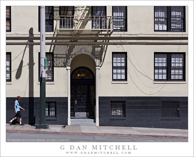
Person in Blue Shirt, Pigeon

Person in Blue Shirt, Pigeon - A person in a blue shirt and a pigeon share a Stockton Street sidewalk in San Francisco.
A person in a blue shirt and a pigeon share a Stockton Street sidewalk in San Francisco.

Person in Blue Shirt, Pigeon. San Francisco, California. August 5, 2012. © Copyright 2012 G Dan Mitchell – all rights reserved.

A person in a blue shirt and a pigeon share a Stockton Street sidewalk in San Francisco.

Continuing my fascination with the walls of San Francisco buildings… this one is on Stockton Street just above China Town, and near the base of stairs descending from an overhead portion of the street under which Stockton continues through a tunnel. After I made this photograph I realized that I had also photographed it last year, from almost the same position and also with figures in front of it. But I decided that I like the subtle pigeon (perhaps hard to see in this small presentation) in front of the doorway, the guy in the blue shirt and shorts sauntering into the frame, and the fairly harsh front-lighting and shadows.

G Dan Mitchell is a California photographer whose subjects include the Pacific coast, redwood forests, central California oak/grasslands, the Sierra Nevada, California deserts, urban landscapes, night photography, and more.
Blog | About | Flickr | Twitter | FacebookGoogle+ | 500px.com | LinkedIn | Email

Text, photographs, and other media are © Copyright G Dan Mitchell (or others when indicated) and are not in the public domain and may not be used on websites, blogs, or in other media without advance permission from G Dan Mitchell.