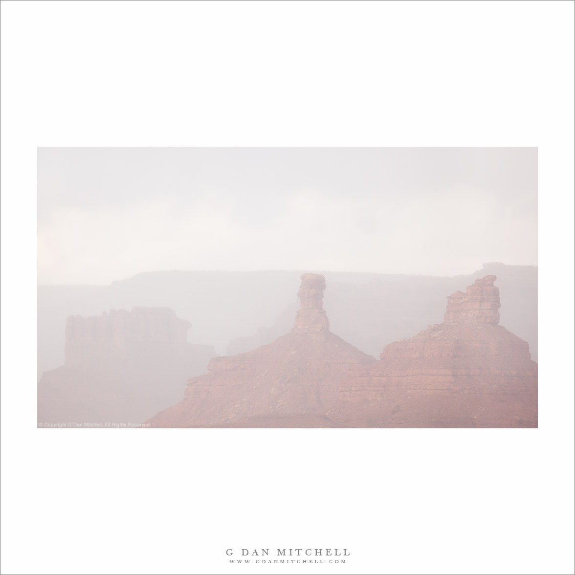
“Monument Valley Squall” — A passing rain squall mutes the view of buttes and ridges at Monument Valley.
This was a spectacular day in Northern Arizona. We were most of the way through a visit of several weeks to Southern Utah, and we had departed Moab that morning. Our plan was to go back via the route through northern Arizona and make it to Springdale, Utah by the end of the day. As we left Utah and started west across Arizona there were spectacular clouds and intermittent heavy showers.
As we approached this area, with its famous buttes, spires, and towers, a heavy shower passed between us that the distant scenery. At first I was disappointed, as it obscured the clear view I was expecting. But in the end, I think that this curtain or rain produced a sense of mystery that is not so present in a typical sharp and clear photograph.
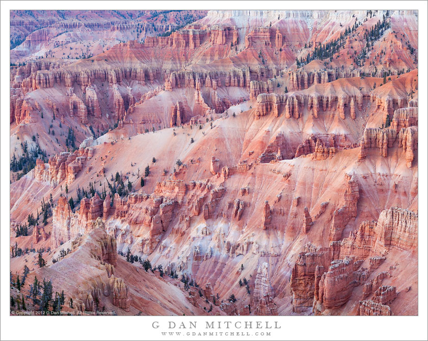
Soft evening light on the formations of Cedar Breaks National Monument
This was only my second photography trip to Utah — the first had been not long before this when we visited in spring. (When I was very young, my family used to drive through Utah on trips between California and the Midwest, but I was hardly aware of the landscape.) This time we aimed for autumn, leaving the eastern Sierra at the beginning of October and heading across Nevada (not the usual route!) to western Utah and staying near Cedar Breaks National Monument for a few days at the start of our visit.
I did not know much about Cedar Breaks, and one thing that surprised me was the abrupt break between the wildly colorful and sculpted pink rock of the canyon and the flat and relatively plain high country to the east. A road travels along this boundary, and it took me a while to figure out how to photograph the area — the high flatlands seemed plain and the canyon dropped away into the western light. But that light from the west turned out to be the key. Near the end of our visit we were along the southern edge of the chasm late in the day when high, thin clouds softened that light from the west, and from here, rather than photographing straight into it, I could focus on the textures and colors made visible by the light sweeping across from the left.
As you consider this beautiful scene, also consider that such areas in Utah are currently threatened by radical anti-environmental Utah politicians who seem hell-bent on giving away our shared public lands to special interest extraction industries. It is simply astonishing that people who live in a place of such beauty could be so blind to it. Consider supporting the Southern Utah Wilderness Alliance in their work to defend these treasures.
Sandstone towers and cliffs in evening light, Capitol Reef National Park
By comparison to some of the other well-known Utah national parks, it seems to me that Capitol Reef is perhaps a bit more difficult to get to know. Oddly, this might be partially because it is so easy to experience it very superficially. A main highway passes right though the park, and a number of the characteristic and iconic features are visible from the highway or by barely leaving it: the well-known orchards, accessible examples of rock art, large and impressive sandstone walls and towers, the Fremont River. Other features are neatly containing along an impressive “scenic drive” with some popular trails. But it seems that the steps to see additional aspects of the park are bigger than at some other parks. For example, while most Yosemite visitors think of The Valley as the park, it isn’t really all that difficult to drive paved roads to Glacier Point, redwood groves, or even the summit of the Sierra. But to go a bit further at Capitol Reef you might have to drive through a river, have four-wheel drive, ask someone about some relatively unknown canyon, drive for many miles on gravel roads.
My first visit to this park was limited to the most accessible features, as we were passing through on our way to another place. We stopped briefly to see the rock art, and I saw those iconic orchards of Fruita. On the second visit, we had more time – we were in the area of several days – and we spent time on the “scenic drive,” did a few of the hikes, and poked around the fringes of these area. We even drove the dozens of miles down that east side gravel road and took a long drive on less-used roads to return to where we started. On a subsequent trip, we asked around a bit, and ended up poking into a canyon where we were the only visitors and walking along a route high in the mountains on a sub-freezing morning. This photograph comes from the intermediate experience of that second trip. Although there was (and still is!) much that I don’t know about this huge and diverse park, by this point I was starting to get a sense of the rhythms of light and so forth, and this enable us to be at this (accessible) location at the right hour as the day came to an end.
G Dan Mitchell is a California photographer whose subjects include the Pacific coast, redwood forests, central California oak/grasslands, the Sierra Nevada, California deserts, urban landscapes, night photography, and more. Blog | About | Flickr | Twitter | Facebook | Google+ | 500px.com | LinkedIn | Email
Sunset light on sparse trees, hoodoos, and descending aretes at Cedar Breaks National Monument, Utah
Cedar Breaks National Monument is almost (but not quite!) a sort of “one trick pony” of a park, though it is quite a spectacular pony! The main draw is the steep and very colorful Bryce-like canyon that drops precipitously from a high ridge along which the park road runs. Below this ridge, beautiful pink layers are exposed, and they have been heavily weathered and eroded into ridges, canyons, steep cliffs, and hoodoo, dotted here and there with a few sparse trees. The canyon faces roughly west, to the late afternoon and evening light on these red rock formations can be quite stunning. (Meanwhile, above the drop-off, the land is entirely different, consisting of gently rolling highland forest mixed with meadows.)
On our first day in the area we got settled in to lodging at nearby Brian Head ski area – where rooms were available at really low rates since this was probably about as “off-season” as you can be! We had some time in the evening so we headed up the road out of Brian Head and were quickly inside the monument. There are quite a few viewpoints along this road, so we picked one. This photograph was in light softened by low clouds on the horizon that still allowed a bit of fading light to illuminate the canyon features from the right.
G Dan Mitchell is a California photographer whose subjects include the Pacific coast, redwood forests, central California oak/grasslands, the Sierra Nevada, California deserts, urban landscapes, night photography, and more. Blog | About | Flickr | Twitter | Facebook | Google+ | 500px.com | LinkedIn | Email
Photographer and visual opportunist. Daily photos since 2005, plus articles, reviews, news, and ideas.
Manage Consent
To provide the best experiences, we use technologies like cookies to store and/or access device information. Consenting to these technologies will allow us to process data such as browsing behavior or unique IDs on this site. Not consenting or withdrawing consent, may adversely affect certain features and functions.
Functional
Always active
The technical storage or access is strictly necessary for the legitimate purpose of enabling the use of a specific service explicitly requested by the subscriber or user, or for the sole purpose of carrying out the transmission of a communication over an electronic communications network.
Preferences
The technical storage or access is necessary for the legitimate purpose of storing preferences that are not requested by the subscriber or user.
Statistics
The technical storage or access that is used exclusively for statistical purposes.The technical storage or access that is used exclusively for anonymous statistical purposes. Without a subpoena, voluntary compliance on the part of your Internet Service Provider, or additional records from a third party, information stored or retrieved for this purpose alone cannot usually be used to identify you.
Marketing
The technical storage or access is required to create user profiles to send advertising, or to track the user on a website or across several websites for similar marketing purposes.