
Tag Archives: mount

Owens Valley, Tungsten Hills, and Mount Tom

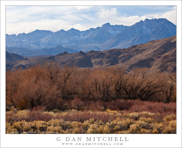
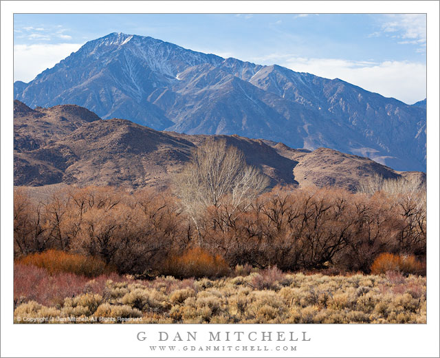
Owens Valley, Tungsten Hills, and Mount Tom - Massive Mount Tom rises above the Tungsten Hills and the high desert terrain of Owens Valley near Bishop, California.
Massive Mount Tom rises above the Tungsten Hills and the high desert terrain of Owens Valley near Bishop, California.

Owens Valley, Tungsten Hills, and Mount Tom. Eastern Sierra Nevada, California. January 2. 2012. © Copyright 2012 G Dan Mitchell – all rights reserved.

Massive Mount Tom rises above the Tungsten Hills and the high desert terrain of Owens Valley near Bishop, California.

When I’m driving to a photography destination, I often have to suppress the desire to stop and make photographs along the way. If I’m not careful, I can end up spending extra hours on the drive and arrive too late. (Sometimes I plan extra time for my long drives just to accommodate my need to stop and photograph en route.) I cope with sighting photographic potential as I drive by either pretending it isn’t there, filing it away for a later trip… or occasionally giving in and stopping.

As I headed down highway 395 on this winter afternoon, on my way to get a camp site in Death Valley, I was aware of the fact that if I took too long I would end up having to find a camp site and set up camp after dark when I arrived – and my destination was still hours away. But after descending to Round Valley just north of Bishop, California I became more aware of the interesting and somewhat unusually afternoon winter light and I finally just had to make a quick stop. The foreground Owens Valley high desert plants had lost all of their “green,” and now had a range of shades of yellow, brown, red, white, black, and even a bit of near-purple. Beyond them the Tungsten Hills began the rise from the valley toward the crest of the eastern escarpment of the Sierra, here dominated by the bulk of massive Mount Tom, a very tall peak that appears even larger because it sits more to the east than most of the other high peaks. The combination of backlight from above the range and high, thin clouds created a sort of muted sunny effect.

G Dan Mitchell is a California photographer whose subjects include the Pacific coast, redwood forests, central California oak/grasslands, the Sierra Nevada, California deserts, urban landscapes, night photography, and more.

Blog | About | Flickr | Twitter | FacebookGoogle+ | 500px.com | LinkedIn | Email

Text, photographs, and other media are © Copyright G Dan Mitchell (or others when indicated) and are not in the public domain and may not be used on websites, blogs, or in other media without advance permission from G Dan Mitchell.
Mount Humphreys and the Sierra Crest, Dawn

Mount Humphreys and the Sierra Crest, Dawn

Mount Humphreys and the Sierra Crest, Dawn. Near Bishop, California. October 15, 2011. © Copyright 2011 G Dan Mitchell – all rights reserved.

Dawn light falls on the snow-dusted summit of Mount Humphreys and the Sierra Crest above Bishop, California.

On this morning I paused along highway 168 on my way to photograph fall aspen color in the Bishop Creek Canyon area to photograph the first light on the Buttermilk Range and along the section of the Sierra crest near Mt. Humphreys and Center Peak. My main reason for stopping here was to photograph the Buttermilks, the rocky hills along the giant “fan” rising from Bishop toward the base of the escarpment of the eastern Sierra. The plan was to find a good vantage point, put a long lens on the camera, and then pick out various features of the range as the edge of the first light hit them.

With that in mind, I was set up here before dawn and standing around in the cold morning air waiting for the light to arrive. Obviously, before the dawn light can get down to the elevation of the Buttermilks it must first hit the peaks of the crest, and who can resist that kind of light? The very first light that just touched the tip of Mount Humphreys, near the right side of the frame, was almost too intense in comparison to the shadowed lower slopes, so I continued to wait until the light, still very saturated with color, illuminated the full upper faces of the crest and began to light up the lower peaks to the east.

G Dan Mitchell is a California photographer whose subjects include the Pacific coast, redwood forests, central California oak/grasslands, the Sierra Nevada, California deserts, urban landscapes, night photography, and more.
Blog | About | Flickr | Twitter | FacebookGoogle+ | 500px.com | LinkedIn | Email

Text, photographs, and other media are © Copyright G Dan Mitchell (or others when indicated) and are not in the public domain and may not be used on websites, blogs, or in other media without advance permission from G Dan Mitchell.
Sunrise, Ediza Lake, Minarets, and Mounts Ritter and Banner

Sunrise, Ediza Lake, Minarets, and Mounts Ritter and Banner

Sunrise, Ediza Lake, Minarets, and Mounts Ritter and Banner. Sierra Nevada, California. July 25, 2007. © Copyright 2007 G Dan Mitchell – all rights reserved.

First sunrise light on the Minarets, Mount Ritter, and Banner Peak above Ediza Lake, Sierra Nevada, California.

I made this photograph during a long and leisurely pack trip into the Minarets area of the Sierra Nevada near Mammoth Lakes. It was leisurely because I accompanied my brother and his family – and the fact that some kids were on the trip contributed to the slower hiking pace… as did the fact that both he and I wanted to make photographs.

This is a popular and accessible area of the Sierra, and also one that is a bit unusual. Typically the highest peaks of the range are found on the actual crest, but here the Sierra crest is further to the east and rather low, being right about where the Mammoth Ski Area is located. Across an intervening valley – a valley that holds Devils Postpile National Monument – loom the high and jagged peaks of the Minarets, a series of impressive spires, and the summits of Mount Ritter and Banner Peak. While in most of the Sierra the areas to the east of the highest peaks descend rapidly to the high desert, here the areas below these peaks remain very high and provide a different view of the eastern faces of the peaks.

The photograph was made very early in the morning along the shoreline of Ediza Lake on a day when clouds were already starting to build even at this early hour. Yes, there was rain later on!

G Dan Mitchell Photography
About | Flickr | Twitter | FacebookGoogle+ | 500px.com | LinkedIn | Email

Text, photographs, and other media are © Copyright G Dan Mitchell (or others when indicated) and are not in the public domain and may not be used on websites, blogs, or in other media without advance permission from G Dan Mitchell.

(Basic EXIF data may be available by “mousing over” large images in posts. Leave a comment if you want to know more.)

Late Afternoon, Tenaya Lake

Late Afternoon, Tenaya Lake

Late Afternoon, Tenaya Lake. Yosemite National Park, California. June 18, 2011. © Copyright G Dan Mitchell – all rights reserved.

Ice covers the surface of Tenaya Lake on the day of the mid-June opening of Tioga Pass Road as afternoon clouds cluster around the summit of Mount Conness, Yosemite National Park.

After the wild sunset-illuminated versions of this scene that I’ve posted recently, I thought it might be a relief to post something more subtle! This photograph was also made on the evening of June 18, the day that Tioga Pass Road opened for the 2011 season. A bit earlier I had photographed along the shoreline of Tenaya Lake – the ice-covered area in the lower portion of this image – where I had juxtaposed melting ice, deep blue water, and interesting clouds. When I finished there I had a decision to make – whether to head back up toward the pass, continue to photograph around the lake, or try to get a shot of Mount Conness from Olmsted Point. Since I had been in contact with a client concerning Mount Conness photographs just a few days earlier, I decided to try that third choice.

When I arrived at Olmsted, conditions were a bit unpromising. Clouds had come up over the Sierra crest and Conness was completely obscured. In addition, a certain type of gloomy haze and cloudiness was taking much of the energy out of the scene. Clouds to the west were washing out the light, too. Many times I don’t give up immediately in situations like this, at least not until I’ve spent a bit of time trying to get a sense of where things might be headed. (Ultimately on this evening that turned out to be a good decision, as near sunset one of the most intense displays of Sierra evening color occurred… but that it a story I’ve already told in earlier posts.) As I watched, the clouds around Conness began to move a bit and every so often a bit of the tip of the mountain would poke through. During one of these moments, a bit of light filtered through the high clouds from the west and glanced across the slopes of Polly Dome and struck the upper reaches of Medlicott Dome.

G Dan Mitchell Photography
Flickr | Twitter (follow me) | Facebook (“Like” my page) | 500px.com | LinkedIn | Email

Text, photographs, and other media are © Copyright G Dan Mitchell (or others when indicated) and are not in the public domain and may not be used on websites, blogs, or in other media without advance permission from G Dan Mitchell.