
Tag Archives: park

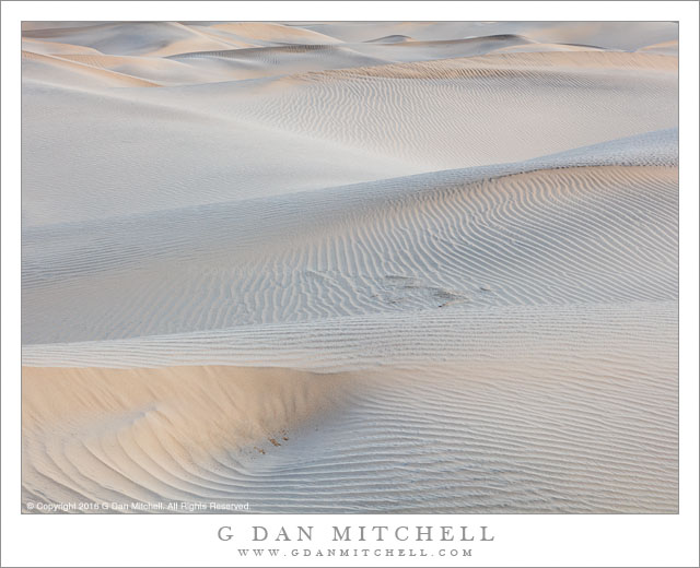
Sand Dunes, First Light

Sand Dunes, First Light
The first morning light reveals textures in sand dunes, Death Valley National Park

Sand Dunes, First Light. Death Valley National Park, California. March 31, 2016. © Copyright 2016 G Dan Mitchell – all rights reserved.

The first morning light reveals textures in sand dunes, Death Valley National Park

These dunes, and others like them, are both more ephemeral and more permanent that many may expect. The permanence initially surprised me. I had always imagined the peaks of dunes marching gradually across the landscape like slow motion ocean waves, producing a landscape that would never be the same twice. However, observing certain dunes in Death Valley National Park over a period of time made it clear that the broad features of the dunes are actually very nearly permanent. From year to year the overall form of the dunes remains largely the same — no surprise, perhaps, given that the forces that form them are constant, including the prevailing winds and surrounding geological features. Yet, other things are more ephemeral. Plants come and go, and footprints are erased by the next dust storm. The light is constantly changing, through the daily cycles and the annual cycle.

This was the final morning of this trip to Death Valley. Since dust storms (and rain!) had passed through the previous evening I was certain that I could find areas unmarked by footprints, where the natural patterns produced by wind would be found. I drove to a less popular area near the dunes, loaded up my equipment, and set out across the playa to get to the low dunes I had in mind. I arrived in soft pre-dawn light and began to photograph, trying to work with this subtle light and its extraordinarily low contrast, all the while watching the sky to the east to see when sunlight would strike the dunes. I composed this photograph in that soft light, but as I worked the sun cleared the mountains far to the east and warmer colored light began to more clearly show the sand patterns. I made this photograph during the very brief interval — literally only seconds — when that first light began to softly light the sand and before it struck with full intensity.


G Dan Mitchell is a California photographer and visual opportunist. His book, “California’s Fall Color: A Photographer’s Guide to Autumn in the Sierra” is available from Heyday Books and Amazon.
Blog | About | Flickr | Twitter | FacebookGoogle+ | 500px.com | LinkedIn | Email


All media © Copyright G Dan Mitchell and others as indicated. Any use requires advance permission from G Dan Mitchell.
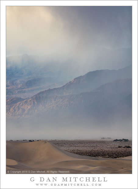
Evening Rain and Sandstorm

Evening Rain and Sandstorm
Evening rain and sandstorm as sun illuminates the Grapevine Mountains

Evening Rain and Sandstorm. Death Valley National Park, California. March 30, 2016. © Copyright 2016 G Dan Mitchell – all rights reserved.

Evening rain and sandstorm as sun illuminates the Grapevine Mountains

During the spring season in Death Valley National Park almost anything can happen. It can be 90 degrees or higher, or it might snow. Days may be pleasant to sunny, or it could be overcast with huge winds and dust storms or rain. We just spent the better part of five days there, and I think I saw as great a range of conditions as I’ve encountered before. The second evening was particularly remarkable. We were up in Panamint Mountains when we first noticed the tell-tale haze of dust storms, and by the time we returned to the Valley it was so windy that there was nothing to do but hunker down and wait it out. Near sunset the winds began to abate a bit and we ventured outside. I heard a few claps of thunder and it began to rain huge drops. Later we discovered that it had snowed on the highest peaks.

A few days later the conditions were supposed to be more benign. We spend early morning hours photographing out on the dunes, then did a midday and afternoon hike up a beautiful canyon. Exiting the canyon we were surprised to see dust beginning to rise again, since the forecast had called for very light winds. By the time we got back to Stovepipe Wells the winds were howling, light rain was falling, and dust filled the atmosphere. A bit later things calmed down and I decided to make a quick evening trip to a nearby high point from which I could get an overview of the valley. Arriving there I could see a wild combination of dramatic light on up-valley mountains, rain falling on their summits, and the dust storm growing below. Within minutes of making this photograph the wind began to howl and the dust enveloped my position and I retreated once more.


G Dan Mitchell is a California photographer and visual opportunist. His book, “California’s Fall Color: A Photographer’s Guide to Autumn in the Sierra” is available from Heyday Books and Amazon.
Blog | About | Flickr | Twitter | FacebookGoogle+ | 500px.com | LinkedIn | Email


All media © Copyright G Dan Mitchell and others as indicated. Any use requires advance permission from G Dan Mitchell.
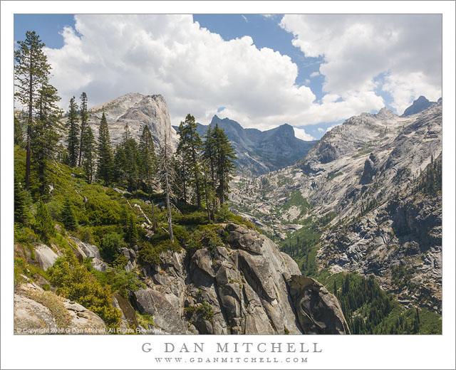
High Sierra Trail

High Sierra Trail
High Sierra Trail to Hamilton Lakes

High Sierra Trail. Sequoia National Park, California. August 5, 2008. © Copyright 2008 G Dan Mitchell – all rights reserved.

High Sierra Trail to Hamilton Lakes

Sometimes I backpack alone and sometimes I travel with friends — and both are great. While I treasure the freedom and solitude of solo backcountry travel, I have been fortunate enough to find friends who share my interest, some of whom have backpacked with me for decades. This trip marked the third time I had been across this section of trail. The first time was quite a few years ago, when Patty and I went on our first long backpack trip, spending two weeks along the High Sierra trail as we traversed it from west to east. The second time I was traveling solo. In fact, it was my first solo pack trip, a two-week journey that took me a ways out on this trail, after which I turned north, wandered up Bubbs Creek, over Glen Pass, and around the Rae Lakes before emerging at Kings Canyon.

This third visit was on another trip across the High Sierra trail. Although I had done it years earlier, it was a completely new trip to the rest of my group, a band of backpackers who have traveled the trails together for a long time, plus a couple of new additions. The first few days of the trip traveled up the Kaweah River drainage towards a ridge crossing at Kaweah Gap. The trail mostly stays high on the north side of the canyon, and here above Bearpaw Meadow the trail occasionally travels along granite domes an ledges, always with the spectacular high ridge of the Kaweahs looming ahead.


G Dan Mitchell is a California photographer and visual opportunist. His book, “California’s Fall Color: A Photographer’s Guide to Autumn in the Sierra” is available from Heyday Books and Amazon.
Blog | About | Flickr | Twitter | FacebookGoogle+ | 500px.com | LinkedIn | Email


All media © Copyright G Dan Mitchell and others as indicated. Any use requires advance permission from G Dan Mitchell.
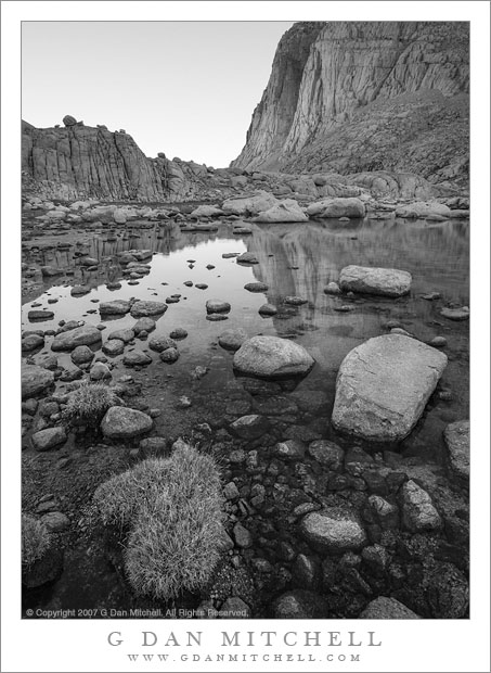
Alpine Pond, Evening

Alpine Pond, Evening
Evening reflections in a boulder-strewn alpine pond, Sequoia National Park

Alpine Pond, Evening. Sequoia National Park, California. August 6, 2007. © Copyright 2007 G Dan Mitchell – all rights reserved.

Evening reflections in a boulder-strewn alpine pond, Sequoia National Park

This pack trip, now almost a decade behind me, was a different sort of trip in several ways. We began on the east side of the range in a high valley south of Mount Whitney. This was in an area that we had visited in the past, and on one occasions I spent several days going up and down an unmaintained pass until we finally all got together and climbed a nearby 14,000′ peak. On the trip where I made the photograph we started out at the same trailhead but then skirted a bit south to cross the crest on a more popular trail. A bit further along to the west we left the main trail to visit a nearby lake, found a cross-country route out of its cirque, walked up a long valley to another lake, and camped there. I made the photograph on the evening of our arrival, looking back at tall ridges lining the valley we had ascended to get here.

There rest of the trip was unusual and special, too. On the next morning we skirted the lake and then headed up to find an unmarked route over a steep pass, dropping down abruptly from its summit into a long granite valley with several lakes. A day later we arrived at the usual west side route towards Mount Whitney. We stopped for lunch and moved on, heading north on the John Muir Trail. Eventually we crossed one of my favorite high spots along this trail and then descended to the junction with the trail over Shepherds Pass. We hung out in this area for a few days, investigating some more remote areas of the Upper Kern drainage before returning to this spot and then heading out over Shepherd Pass.


G Dan Mitchell is a California photographer and visual opportunist. His book, “California’s Fall Color: A Photographer’s Guide to Autumn in the Sierra” is available from Heyday Books and Amazon.
Blog | About | Flickr | Twitter | FacebookGoogle+ | 500px.com | LinkedIn | Email


All media © Copyright G Dan Mitchell and others as indicated. Any use requires advance permission from G Dan Mitchell.