Tag Archives: park

Boulders, Tree, and Dark Granite

Boulders, Tree, and Dark Granite

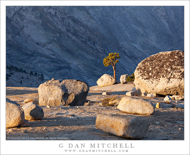
Boulders, Tree, and Dark Granite. Yosemite National Park, California. August 6, 2013. © Copyright 2013 G Dan Mitchell – all rights reserved.

A solitary tree stands on granite slabs among glacial erratic boulders against the dark background of a granite face in shadow

I have previously posted a few photographs from this early August four-day shoot in Yosemite, when I ranged between about Olmsted Point and Mono Lake for about four days. The photography was a bit strange compared to more normal years – there was smoke in the air from a fire near Mammoth Lakes and there was not much water due to the drought afflicting the mountains after a second very dry winter. So some of my photography instincts may have been challenged a bit, and I had to adapt to conditions – sometimes ending up shooting in a different place than planned when the haze was too thick, sometimes using the haze as part of the photograph, and also ranging a bit more widely than I might usually do.

On this morning I had decided to “work” that area between roughly Tenaya Lake and some rocky slabs a bit past Olmsted Point. I began at Tenaya just before sunrise, but the smoke haze was making things difficult. I made a few photographs along the curving shore as the first sun hit nearby ridges, but I wasn’t especially happy with the atmosphere or the color and quality of the light so I moved on. The slabs and domes along the road to the west of Tenaya Lake, which track the road for some distance and spread well beyond the road itself, have been an ongoing subject of interest to me. While the sun had hit the highest peaks by the time I got there, it had not quite worked its way down to these slabs, so I found some likely groups of glacial erratic boulders and various small trees and made some photographs. In this one, a single tree stands beyond a group of large boulders that had just been hit by the first light, and across a nearby canyon large granite walls are still in shadow.

G Dan Mitchell is a California photographer and visual opportunist whose subjects include the Pacific coast, redwood forests, central California oak/grasslands, the Sierra Nevada, California deserts, urban landscapes, night photography, and more.
Blog | About | Flickr | Twitter | FacebookGoogle+ | 500px.com | LinkedIn | Email

Text, photographs, and other media are © Copyright G Dan Mitchell (or others when indicated) and are not in the public domain and may not be used on websites, blogs, or in other media without advance permission from G Dan Mitchell.

Ferns, Olympic Peninsula

Ferns, Olympic Peninsula

Ferns, Olympic Peninsula. Olympic National Park, Washington. August 16, 2013. © Copyright 2013 G Dan Mitchell – all rights reserved.

Lush ferns grow along a trail through rain forest at Olympic National Park

On this day we initially planned to make a quick foray to North Cascades National Park, but I got a call saying that Olympic Peninsula web cams were showing relatively clear skies and that I should think about changing plans – so I did! Instead of heading north from the Seattle area, we headed west and took the ferry across Puget Sound, arriving to find clearing fog and some partial clouds, but quite a bit of sunlight. Taking the advice of someone who knows the Pacific Northwest better than I do, our plan was to first shoot down in the rain forest and then to head up to Hurricane Ridge near the end of the day.

We started at Sol Duc falls, a short one-mile hike from a parking area at the end of a side road. My mental image of these forests involves lush growth, cloudy conditions, and rain. The first was present, but both the clouds and the rain were missing. In some ways that could be a good thing, but shooting in the forest in the midday sun poses major problems. The main issue is so-called “pizza light,” with deep shadows and bright, sunlit highlights mixed together throughout the scene. When we got to the waterfall, that is precisely what we found. The fall is in a narrow gorge – and while the bottom of the gorge was in deep shade, beams of direct sunlight were striking the white water of the fall. While it might be possible to make a photograph of this subject in such conditions, it made a lot more sense to me to turn my attention to smaller scale subject that allowed me to better control the light – and this close up “intimate landscape” of a twisting group of ferns is one of the results.

G Dan Mitchell is a California photographer and visual opportunist whose subjects include the Pacific coast, redwood forests, central California oak/grasslands, the Sierra Nevada, California deserts, urban landscapes, night photography, and more.
Blog | About | Flickr | Twitter | FacebookGoogle+ | 500px.com | LinkedIn | Email

Text, photographs, and other media are © Copyright G Dan Mitchell (or others when indicated) and are not in the public domain and may not be used on websites, blogs, or in other media without advance permission from G Dan Mitchell.

About the Yosemite “Rim” fire… and more

UPDATE and a NOTE:

Update: Shortly after I posted this, my reports on highway 120 through the park via the Tuolumne Meadows area  were rendered incorrect/outdated by way of an updated announcement from the park service as follows:

“Beginning at 12:00pm on Wednesday, August 28th, Tuolumne Meadows and the High Sierra will only be accessible via Highway 120 East through Lee Vining.  The Tioga Rd/Hwy 120 East will be temporarily closed between White Wolf Lodge and the Big Oak Flat Rd./Hwy 120 West at Crane Flat; the closure is estimated to be 3 to 4 days.  Tuolumne Meadows Lodge, the High Sierra Camps, and Tuolumne Meadows and Porcupine Flat campgrounds all remain open.”

Basically, this means that you will not be able to use highway 120 as a route across the Sierra until further notice. I’m not surprised – in fact, I’ve been somewhat surprised that the road remained open this long. Apparently the following URL is also a good source of updates from the park: http://www.yosemitepark.com/yosemite-fire-update.aspx

Note: All of which brings me back to my original statement that I don’t have inside information on this fire, and that anyone traveling to the area needs to check official sources for conditions updates. I will likely not update this page as things change, so the information posted here should be regarded as potentially being out of date!

My original post follows…

A few people have asked me for information about the “Rim” fire which started not far from Groveland near highway 120, and which is currently burning along the northwest boundary of Yosemite National Park, generally moving east and north toward the highway 108 area. While I know much of this area fairly well from many years (decades, actually) of visits, I do not have any inside information about the fire itself, nor am I an expert on wildfires. One good source of (limited but objective) information is the Stanislaus National Forest Rim Fire Incident web page. A map on this page is a quite amazing source of information, especially when combined with some familiarity with the area and a reading of various written reports. (The version on the main page seems to be based on Google Maps, and allows you to scroll around and zoom in.) Lots of folks who live and work in the area are sharing updates on the usual social media sites. The Mariposa Gazette is another local news source.

The fire started on August 17 more or less midway between Groveland and the  northwest park entrance and not far off of the highway 120 corridor near the Rim of the World area overlooking the canyon of the Tuolumne River. (Highway 120 is a common route for entry to the park from the west and northwest, and it connects via Tuolumne Meadows and Tioga Pass to the east side of the Sierra at the town of Lee Vining.) The spread of the fire at first was somewhat quick, which is no surprise given the extremely dry conditions in the Sierra following a second very dry winter and almost no real precipitation since late 2012. Then, between about August 20 and 23, the fire exploded, expanding  very quickly to cover a huge area generally to the east and north of the starting point, with the fire generally racing northeast but also spreading to the north and south. Continue reading About the Yosemite “Rim” fire… and more

Ridges, Evening Light

Ridges, Evening Light
“Ridges, Evening Light” — Evening light shines on forested ridges and high peaks, Olympic National Park

I have not had a lot of luck trying to photograph the Hurricane Ridge area in the past. You’ve probably seen the beautiful and iconic photographs by other photographers – lavish displays of wildflowers, striking alpine ridges holding snow fields and glaciers, spectacular cloud-filled skies. However, on the few occasions when I have tried to shoot there I have contended with wind, fog that held visibility down to mere yards, and poor seasonal timing. Since we were in the Seattle area (for something non-photographic) with a free day, I figured I might try one more time. Initially I had thought of the run up to Artist Point in North Cascades, but the weather forecast there was not at all promising, with rain expected. Initially I thought that there might be similar weather out on the Peninsula, but as we started out I got a call from my brother, who is a Seattle area photographer much more familiar with the patterns of the area, saying “go to the Olympic Peninsula. I’m looking at a web cam and it seems clear!”

In fact, by the time our ferry crossed to the west side of Puget Sound, it was looking quite clear. After some midday, lowland shooting, we figured that we would try Hurricane Ridge at the end of the day. With this in mind, it was a bit after 5:00 when we arrived there. The first look around was not too encouraging – the wildflowers were mostly spent and it was cloudy, though sun was breaking through the clouds from time to time. I decided to give it a try since I know that conditions can change quickly and because it was likely too late to get to any other interesting points in the remaining daylight. Setting up and watching the scene, I noticed that while it was cloudy and even a bit rainy, breaks in the clouds to the west were sending occasional beams of light chasing across the landscape, especially the large forest-covered ridge in the foreground of this photograph.


COMMENT OR QUESTION? Scroll down to the comment form.

G Dan Mitchell is a California photographer and visual opportunist. His book, “California’s Fall Color: A Photographer’s Guide to Autumn in the Sierra” (Heyday Books) is available directly from him. Blog | Bluesky | Mastodon | Substack Notes | Flickr | Email

All media © Copyright G Dan Mitchell and others.