Tag Archives: peak

Lake Manly, Winter Sky

Lake Manly, Winter Sky
“Lake Manly, Winter Sky” — Winter sky and its reflection in Lake Manly.

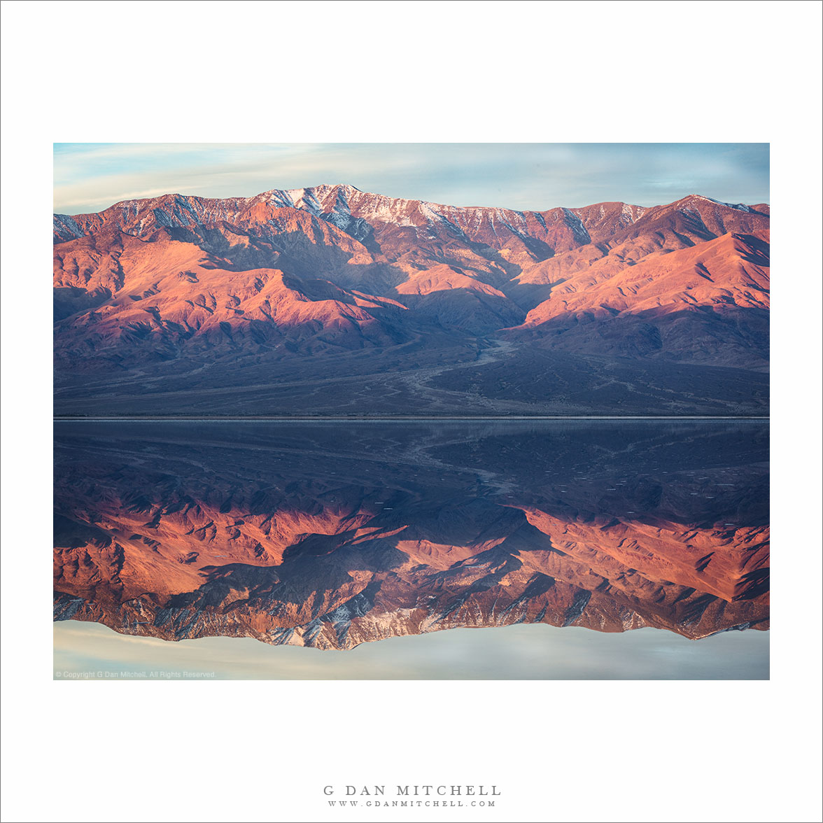
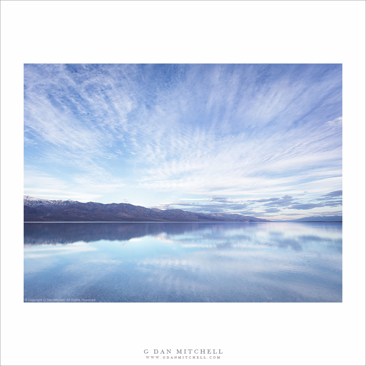
Yes, this is a desert! We are back from our second recent visit to Death Valley. On the first we experienced cool temperatures and rain at the end of December. Since the prospects looked good for wildflowers in the months ahead we booked a late-February return visit. There’s always a lot to photograph in Death Valley but, as a friend pointed out, the stars of the show right now are the wildflowers and Lake Manly. I photographed both, but I’ll start with Lake Manly.

For those who may not know, Lake Manly forms in the Badwater Basin during exceptionally wet years. It was deeper and larger last year, but it is still there and covers a lot of the salt flats. We visited early in the morning this time. The clouds suppressed any brilliant sunrise colors, but as a counterpoint they produced beautiful patterns in the sky which were reflected in the waters of Lake Manly.


Leave a comment or question using the form. (Click the title to see the full article and to comment if you are viewing it on the home page.)

G Dan Mitchell is a California photographer and visual opportunist. His book, “California’s Fall Color: A Photographer’s Guide to Autumn in the Sierra” (Heyday Books) is available directly from him. Blog | Bluesky | Mastodon | Substack Notes | Flickr | Email

All media © Copyright G Dan Mitchell and others.

Telescope Peak, Lake Manly

Telescope Peak, Lake Manly
“Telescope Peak, Lake Manly” — Panamint Range and Telescope Peak reflected in Lake Manly, Death Valley.

This photograph incorporates at least two elements that might surprise people unfamiliar with Death Valley National Park — a large lake and snow-dusted mountain peaks. Telescope Peak, the highest point on the Panamint Range summit ridge, rises just above 11,000′, putting its summit in the alpine zone. It is normal to see snow there during the winter months.

Lake Manly, the body of water reflecting the mountains, is a different matter. Its appearance is somewhat rare, occurring only in years of exceptional rainfall. Although this is now a dry winter in California, a big storm a year ago primed the pump, a monumental November storm re-formed the lake, and there was another storm around Christmas Eve Day. The broad but shallow lake forms on the playa of Badwater Basin, the lowest point in the continental United States.


Leave a comment or question using the form. (Click the title to see the full article and to comment if you are viewing it on the home page.)

G Dan Mitchell is a California photographer and visual opportunist. His book, “California’s Fall Color: A Photographer’s Guide to Autumn in the Sierra” (Heyday Books) is available directly from him. Blog | Bluesky | Mastodon | Substack Notes | Flickr | Email

All media © Copyright G Dan Mitchell and others.

Cathedral Range

Cathedral Range
“Cathedral Range” — The distant Cathedral Range rises above Yosemite high country forests and meadows under evening clouds.

This was the scene late in the day during my early July visit to the High Sierra near Tuolumne Meadows and just east of Yosemite National Park. In the right light, this can be my favorite time of day — the sun Is nearing the horizon and the light is softening and turning golden, and shadows stretch across the landscape. I made the photograph next to a high country meadow that opens to a view of the distant Cathedral Range.

The Cathedral Range has a unique personality. It is not on the Sierra Crest, but instead runs more or less northwest to southeast between the the Tuolumne and Merced Rivers. It rises from mostly forested country to culminate in open granite terrain, with some summits that escaped glaciation and are rugged and steep.


Leave a comment or question using the form. (If you are reading this on the home page, click the article title to see the full article and the comment form.

G Dan Mitchell is a California photographer and visual opportunist. His book, “California’s Fall Color: A Photographer’s Guide to Autumn in the Sierra” (Heyday Books) is available directly from him. Blog | Bluesky | Mastodon | Substack Notes | Flickr | Email

All media © Copyright G Dan Mitchell and others.

Dunderberg Meadows

Dunderberg Meadows
“Dunderberg Meadows” — Autumn aspen stretch across the landscape beneath Eastern Sierra Nevada peaks.

Transition zones in the mountains fascinate me — places where one sort of landscape runs into another. In this photograph from the Eastern Sierra Nevada, aspens extend across high desert sagebrush terrain and right into the lowest conifer forests. The demarcation between sagebrush and forest is fairly sudden, but the aspens live in both.

Decades ago my entire notion of the Sierra Nevada revolved around the forest and alpine zones. For that reason, and because I usually approached the range via its gentle west slope, I did not know about this high desert terrain. It is possible that the first time I encountered this zone was when exiting on the east side after a long walk in the high country — and it was a shock to me.


Leave a comment or question using the form. (Click the title to see the full article and to comment if you are viewing it on the home page.)

G Dan Mitchell is a California photographer and visual opportunist. His book, “California’s Fall Color: A Photographer’s Guide to Autumn in the Sierra” (Heyday Books) is available directly from him. Blog | Bluesky | Mastodon | Substack Notes | Flickr | Email

All media © Copyright G Dan Mitchell and others.