“Lake Manly and Telescope Peak, Dawn” — Dawn light on Telescope Peak above Hanaupah Canyon and the reflective waters of Lake Manly.
This photograph includes a short list of superlative features. Telescope Peak, at just over 11,000′, is the highest point in Death Valley National park. From the peak one can see the highest point in California, Mt. Whitney (in the Sierra Nevada) and the lowest point (Badwater Basin). In the photograph Badwater Basin is submerged beneath Lake Manly, which forms only in very wet years and generally evaporates quickly. Snow on Telescope Peak and the Panamint Range is not unusual in winter, but in this photograph it has reached a rather low elevation.
“Desert Gold Flowers, Panamint Range Mountains” — The snow-capped Panamint Range rises beyond a field of desert gold wildflowers, Death Valley.
What is the popular image of Death Valley National Park? I’d say that it is some combination of the following: desert, sand dunes, arid, empty. There can be some truth to that though it is not quite so uniform. This photograph is an example — it is not empty and there are no sand dunes. Instead we see flowers stretching off into the far distance.
Although it might see counter-intuitive for a place like Death Valley National Park, these mountains typically are snow-capped in the winter. The highest point in the Panamint Range is Telescope Peak, at an elevation of just above 11,000′. That puts it in the alpine zone, and although moisture is usually scarce here, when it does come it can produce snow at that elevation. A cold storm had recently passed, and the snow level in the photo is lower than usual.
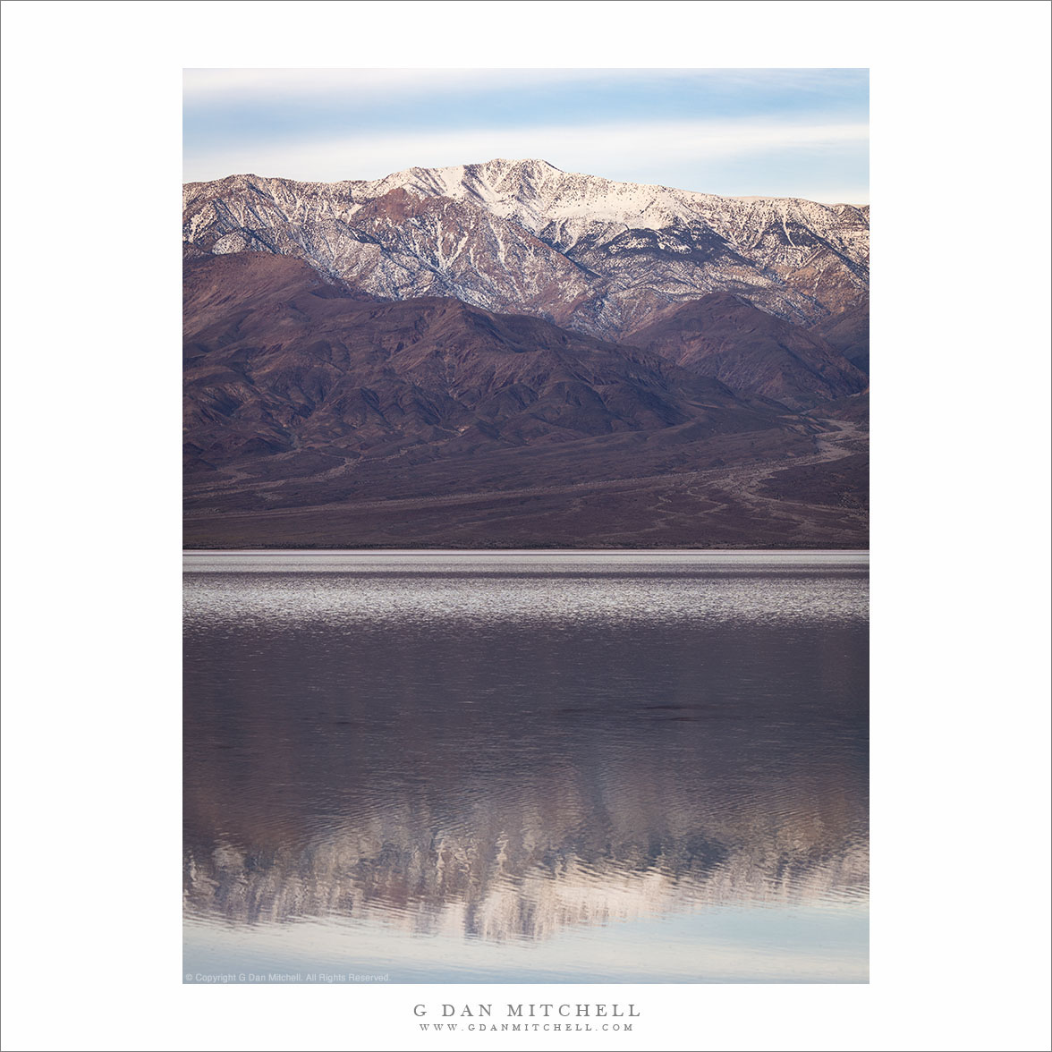
“Badwater Basin to Telescope Peak” — Telescope Peak and the Panamint Range, seen from the shoreline of Lake Manly in Badwater Basin.
There are a few unusual things in this Death Valley photograph featuring Telescope Peak. Superficially, snow at Death Valley might seem unusual, but while it is at lower elevations that usual, these peaks are often snow-capped in winter. More unusual is the band of water at the bottom of the frame — that’s Lake Manly, which may temporarily form in Badwater Basin during wet years. The photograph includes the lowest elevation in the park (Badwater Basin) and its highest (Telescope Peak.)
What lies between those extremes is remarkable, too. That is a rise of over 11, 300′ from below-sea-level Badwater Basin to the summit of the peak. Between those two is some extremely rugged terrain that ranges from low desert to the alpine zone, with everything in between.
Photographer and visual opportunist. Daily photos since 2005, plus articles, reviews, news, and ideas.
Manage Consent
To provide the best experiences, we use technologies like cookies to store and/or access device information. Consenting to these technologies will allow us to process data such as browsing behavior or unique IDs on this site. Not consenting or withdrawing consent, may adversely affect certain features and functions.
Functional
Always active
The technical storage or access is strictly necessary for the legitimate purpose of enabling the use of a specific service explicitly requested by the subscriber or user, or for the sole purpose of carrying out the transmission of a communication over an electronic communications network.
Preferences
The technical storage or access is necessary for the legitimate purpose of storing preferences that are not requested by the subscriber or user.
Statistics
The technical storage or access that is used exclusively for statistical purposes.The technical storage or access that is used exclusively for anonymous statistical purposes. Without a subpoena, voluntary compliance on the part of your Internet Service Provider, or additional records from a third party, information stored or retrieved for this purpose alone cannot usually be used to identify you.
Marketing
The technical storage or access is required to create user profiles to send advertising, or to track the user on a website or across several websites for similar marketing purposes.