
Tag Archives: ridge

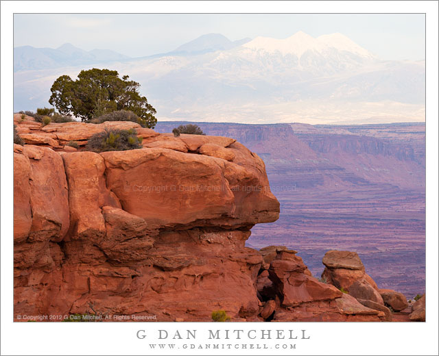
Juniper, Red Rock, La Sal Mountains

Juniper, Red Rock, La Sal Mountains - A Utah juniper growing on red rock with the La Sal Mountains in the distance, Grand View overlook, Canyonlands National Park
A Utah juniper growing on red rock with the La Sal Mountains in the distance, Grand View overlook, Canyonlands National Park

Juniper, Red Rock, La Sal Mountains. Canyonlands National Park, Utah. October 10, 2012. © Copyright 2012 G Dan Mitchell – all rights reserved.

A Utah juniper growing on red rock with the La Sal Mountains in the distance, Grand View overlook, Canyonlands National Park.

We had a great visit to Canyonlands National Park, though the lighting was challenging, to say the least. Our visit took us up to the “island in the sky” highlands and included a stop at the Dead Horse Point State Park. Initially, the light challenges were simply from the midday light and the fact that there was a certain amount of haze in the air. The haze can be a nice effect in some cases, but it can also obscure some of the longer views such as those from this high plateau. As the day wore on, clouds began to collect to the west and, as luck would have it, the thickest portion of the clouds were almost directly west of us. Ultimately, this interfered with my chances for dusk shooting, but sometimes that’s just the way it goes.

Before heading to the golden hour light location that I had selected, we drove down to the “Grand View” overlook – appropriately named, as anyone who has been there can confirm. Here the high plateau ends suddenly with a steep thousand foot drop off to the next lower level of strata and the Green River joins the Colorado in the vast and rugged terrain to the south. I did eventually make some photographs of that subject – it is sort of obligatory! However, as I walked to the overlook I saw to my left this chunk of cliff-edge sandstone with its resident juniper and remembered looking at it the last time I was there. The soft light produced by the overcast was a Good Thing here, as full sun would have produced a very harsh effect on the rocks. Beyond lies the giant valley of the Colorado River and even further out are the high and distant peaks of the La Sal mountains.

G Dan Mitchell is a California photographer whose subjects include the Pacific coast, redwood forests, central California oak/grasslands, the Sierra Nevada, California deserts, urban landscapes, night photography, and more.
Blog | About | Flickr | Twitter | FacebookGoogle+ | 500px.com | LinkedIn | Email

Text, photographs, and other media are © Copyright G Dan Mitchell (or others when indicated) and are not in the public domain and may not be used on websites, blogs, or in other media without advance permission from G Dan Mitchell.
Autumn Aspens, Sabrina Basin

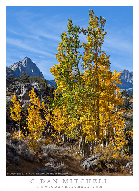
Autumn Aspens, Sabrina Basin - Aspen trees with golden autumn colors, Sabrina Basin near North Lake
Aspen trees with golden autumn colors, Sabrina Basin near North Lake

Autumn Aspens, Sabrina Basin. Eastern Sierra Nevada, California. October 3, 2012. © Copyright 2012 G Dan Mitchell – all rights reserved.

Aspen trees with golden autumn colors, Sabrina Basin near North Lake

I had heard reports that the eastern Sierra aspen color was not very good at the beginning of October this year, and I already know that it was an unusual season with an earlier-than-normal color change. (I had seen some early color back in the middle of September while on a short backpack trip.) People I trust and whose reports I read had visited the area shortly before I did, and some of them had reported poor color and even trees that can lost leaves at the start of the month. Since I only really had a single day for Sierra aspen photography this year I was hopeful that they were wrong or at least that I could find a few trees in good shape, since sometimes a single branch with colorful leaves can be enough.

Much to my surprise, when I traveled up into the Bishop Creek drainage on October 3, I found a lot of excellent color. Maybe I just looked in the right places or perhaps I got lucky, but I found wonderful opportunities to photograph the aspens, and in many places I found trees at their peak of color. (This was, indeed, perhaps a week earlier than what I would expect in a more typical year.) These trees are part of a well-known group that is not far from the North Lake area – the morning light just clearing the ridge to the left of this scene and the wispy clouds were pluses.

G Dan Mitchell is a California photographer whose subjects include the Pacific coast, redwood forests, central California oak/grasslands, the Sierra Nevada, California deserts, urban landscapes, night photography, and more.
Blog | About | Flickr | Twitter | FacebookGoogle+ | 500px.com | LinkedIn | Email

Text, photographs, and other media are © Copyright G Dan Mitchell (or others when indicated) and are not in the public domain and may not be used on websites, blogs, or in other media without advance permission from G Dan Mitchell.

Beaver Pond, McGee Creek

Beaver Pond, McGee Creek - A beaver pond floods a low area of McGee Creek below the peaks at the edge of Pioneer Basin.
A beaver pond floods a low area of McGee Creek below the peaks at the edge of Pioneer Basin.

Beaver Pond, McGee Creek. Eastern Sierra Nevada, California. September 16, 2012. © Copyright 2012 G Dan Mitchell – all rights reserved.

A beaver pond floods a low area of McGee Creek below the peaks at the edge of Pioneer Basin.

Unlike some so-called beaver ponds in the Sierra, this one really does appear to be the home  of beavers. If you look closely near the far bank of the pond, just left of center, you can see the distinctive peaked beaver den.

This spot was a bit of a landmark on the trail up McGee Canyon on my mid-September backpack trip to Steelhead Lake. Before this the trail mostly crossed relatively dry and open terrain, but starting at this point there was more forest cover, and the valley gradually began to become more rocky and narrower. There is just a bit of early fall color in this photograph. The plants around the pond have obviously gone brown, and  some of the aspens and other brush ascending the slopes of the canyon are just barely beginning to change – what I sometimes call the “lime green” stage where it starts to become clear that the real color change is not far away. The distant tall ridge marks the boundary between the McGee Creek drainage and Pioneer Basin. I’m not positive, but I think that the two high points on the ridge might be Mounts Stanford and Crocker,  part of a group of four peaks ringing Pioneer Basin that are named after the four “railroad barons, the other two being Huntington and Hopkins.

Unlike most of my mountain photographs, this was essentially a handheld “snap” – though made with a good camera and lens. When I’m hiking I carry my camera and two lenses in a chest strap mounted front carrier so that I can make some photographs while on the move without having to remove my pack. This sort of shot, made at a time of less than optimum light, is an example of the sort of thing that I’ll occasionally shoot that way.

G Dan Mitchell is a California photographer whose subjects include the Pacific coast, redwood forests, central California oak/grasslands, the Sierra Nevada, California deserts, urban landscapes, night photography, and more.
Blog | About | Flickr | Twitter | FacebookGoogle+ | 500px.com | LinkedIn | Email

Text, photographs, and other media are © Copyright G Dan Mitchell (or others when indicated) and are not in the public domain and may not be used on websites, blogs, or in other media without advance permission from G Dan Mitchell.

Glacial Erratics, Near Olmsted Point

Glacial Erratics, Near Olmsted Point - Glacial erratic boulders rest on a tree-topped granite slab at sunset near Olmsted Point, Yosemite National Park
Glacial erratic boulders rest on a tree-topped granite slab at sunset near Olmsted Point, Yosemite National Park

Glacial Erratics, Near Olmsted Point. Yosemite National Park, California. September 16, 2012. © Copyright 2012 G Dan Mitchell – all rights reserved.

Glacial erratic boulders rest on a tree-topped granite slab at sunset near Olmsted Point, Yosemite National Park

Among the various landscapes of the high Sierra, this sort of scene most clearly says “Yosemite” to me: the glaciated granite slabs, mostly solid but broken but exfoliating and broken by cracks; the scattered glacial erratic boulders left behind by retreating ice; and the sparse trees somehow managing to not only survive but seemingly prosper while growing on almost solid rock. Although you don’t see precisely these things in the better known Valley, once you get up into the high country of the park you’ll see these features almost everywhere, and especially in the zone from, say, 8000′ of elevation or so and on up.

This photograph was made close to Olmsted Point. While Olmsted is probably better known for its “backside” view of Half Dome and its huge views up toward Tenaya Lake and on to the Sierra crest at Mount Conness, the immediate surroundings are full of this typical Sierra terrain that I described above. Most of the terrain above, below, and around the Point shows evidence of this glacial action, and by taking a few steps away from the parking lot in almost any direction (but do avoid cliffs!) you can find enough examples of this landscape to keep yourself occupied for a long time.

G Dan Mitchell is a California photographer whose subjects include the Pacific coast, redwood forests, central California oak/grasslands, the Sierra Nevada, California deserts, urban landscapes, night photography, and more.
Blog | About | Flickr | Twitter | FacebookGoogle+ | 500px.com | LinkedIn | Email

Text, photographs, and other media are © Copyright G Dan Mitchell (or others when indicated) and are not in the public domain and may not be used on websites, blogs, or in other media without advance permission from G Dan Mitchell.