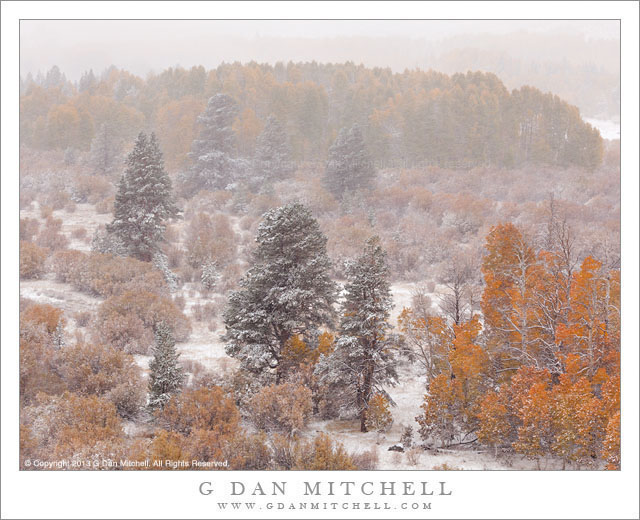
An early autumn snow storm obscures the view of pines, aspens and other fall foliage in the eastern Sierra Nevada
This photograph, like a few others I have posted this fall, was made on an early October day when we drove across the Sierra from west to east during the first “real” snow of the season. Our goal was Bishop, California, since we planned to photograph autumn aspen color on the “east side” for a few days. Since the usual more direct route over Tioga Pass was closed due to snow, we ended up crossing all the way up close to Tahoe over Carson and then Monitor Passes to get to highway 395, which we then followed southwards along the east side of the Sierra.
The snow began before we reached Carson pass, and though it never fell very heavily, it more or less continued for the rest of the drive, only stopping shortly before we got to Bishop. This was quite a contrast to the weather we had been having, which had been up into the low 90s in our part of California only a few days earlier! Since we had the whole day to get to Bishop we made frequent stops and detours along the way, giving us lots of opportunities to photograph scenes that had a distinctly winter-like appearance. One place we paused was along a high point on highway 395 just north of Lee Vining, where huge groves of colorful aspen trees were just visible through the blowing snow. Turning slightly away from the aspen color, I chose to make a few isolated evergreen trees the focus of this photograph.
G Dan Mitchell is a California photographer and visual opportunist whose subjects include the Pacific coast, redwood forests, central California oak/grasslands, the Sierra Nevada, California deserts, urban landscapes, night photography, and more. Blog | About | Flickr | Twitter | Facebook | Google+ | 500px.com | LinkedIn | Email
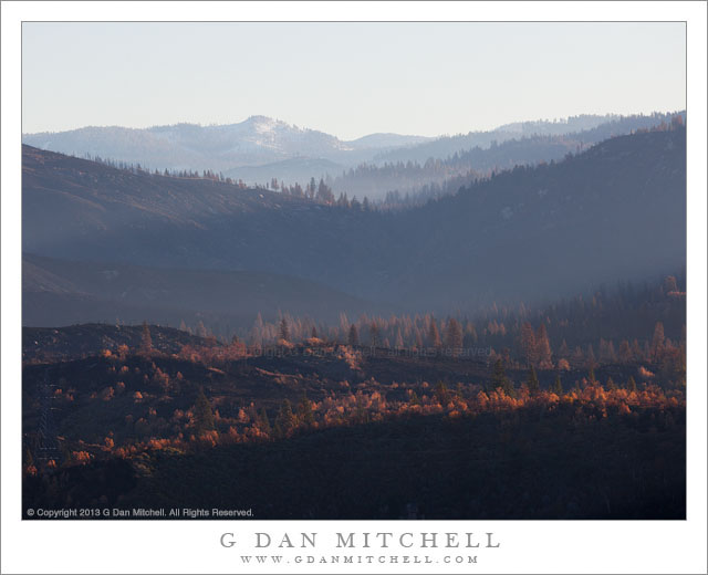
Hazy morning light filters across the burned hillsides in the area of the Rim Fire, California
In photographic terms this is perhaps not the most spectacular photograph, and the location is not quite a scenic icon – though it is a place that many stop and take a look on their way to Yosemite, the “Rim of the World” overlook along highway 120 between Groveland and the northern park entrance. However, this view is loaded with implications and connected to many stories.
Late this past summer, the state of California was tremendously dry after a second drought season. It wasn’t a question of whether there would be big wildfires, but more of where, when, and how many. Perhaps the biggest one of all started very near the Rim of the World overlook, and in the hot and dry conditions it quickly – some might say explosively – spread to the north, east, and south. While many think of it as “the Yosemite fire” – and it did burn a lot of terrain inside the park – it really was more of a “Yosemite area” fire. Because of the conditions – the long-term conditions of drought and the immediate conditions of heat and wind – the fire apparently did very serious damage to the forests in the are.
Shortly after the fire was contained, I thought that I might drive through the park on Tioga Pass Road to get to and from the eastern Sierra in early October. In fact, the roads had opened up again by that time, but snow closed Tioga Pass on my trip to the west and we ended up coming back over Sonora Pass. So the post-fire conditions of this area, which is very familiar to me after years of visits, were still an unknown when I drove to The Valley on October 30 for a few days of autumn photography. Passing into the first fringes of the burned areas along highway 120 things didn’t look all that different than they do after any wildfire – some areas badly burned, some singed, and others that mostly escaped the fire. I decided to stop at the Rim of the World overlook, which was pretty much the only place where stopping was allowed, and get out and take a look. I was floored by the scale of the fire. It had come from behind my position, burned down and across the deep canyon of the Tuolumne River, up the canyon walls on the far side, and then across a vast series of receding ridges. Some smoke and haze still seemed to be coming from the area, and early morning light glanced across the ridges, with their dead trees. In the far distance there is a low peak with a bit of early season snow.
I have seen quite a few fires in the park over the past few decades. One not far from here destroyed a large area of forest a few decades ago – and on this trip, ironically, I was noting that new evergreen trees are finally taking hold there. Later several very bad fires blew up from near Foresta, doing terrible damage to the section of Crane Flat Road descending towards The Valley. There have been others. In most of these cases – though I wondered in the case of the most recent Foresta fire, too – it seemed that I could watch the forest recover and return to something resembling what I remember. However, given the intensity and scale of this fire, I wonder if I’ll have that opportunity where the Rim Fire burned?
To end on a cheerier note, a couple of other observations. Even near badly burned areas, I did see sections where this fire only burned some of the vegetation and a few that seemed to have been completely spared. And when I got to a spot inside the park along highway 120 where I often stop to photography dogwood trees in the spring and fall, a spot that seemed like it might have been within the burn zone on the maps, I found my little spot completely intact, with the dogwoods turning to fall colors.
G Dan Mitchell is a California photographer and visual opportunist whose subjects include the Pacific coast, redwood forests, central California oak/grasslands, the Sierra Nevada, California deserts, urban landscapes, night photography, and more. Blog | About | Flickr | Twitter | Facebook | Google+ | 500px.com | LinkedIn | Email
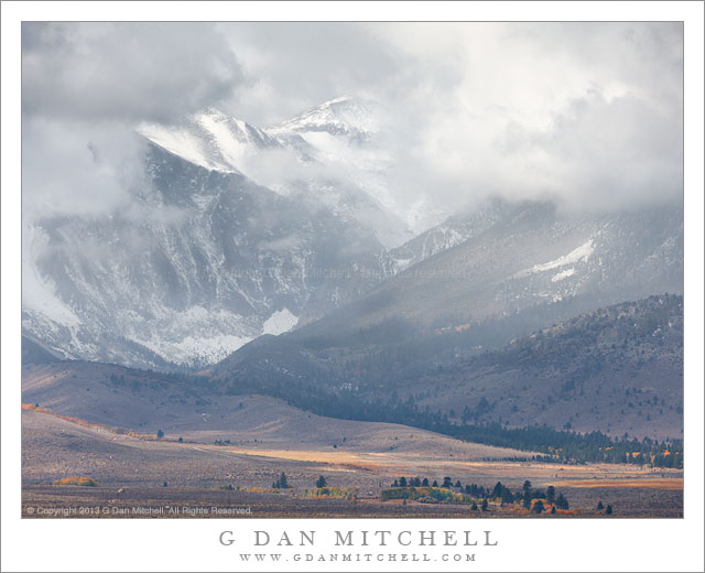
An October storm brings snow to the Parker Canyon area of the eastern Sierra Nevada
This is yet another photograph from our early October “aspen chasing” trip to photograph fall color in the eastern Sierra. We were on the “east side” for five days, in conditions that began with a full day of snow, then turned mostly sunny for a few more days, and returned to more winter-like weather on our final day. On that last day of the visit we tracked far to the east of the Sierra, out into high desert ranges where we saw many interesting things including a number of stands of aspens in surprising and less-visited places.
We looped back from the east and passed by the south shore of Mono Lake, and coming over the rise between there and highway 395 we were not surprised to see a substantial chunk of the Sierra crest laid out before us… but we were a bit surprised to see that it appeared to still be snowing along the crest. We had awakened to light snow in Mammoth Lakes that morning, but assumed that it was just a passing squall. This seemed to be the case, as we did not see much more in the way of precipitation as we headed east. But these were apparently the sort of conditions in which storm clouds form right over the crest, and the result was this very dramatic scene. Low in the frame, the foreground hills pick up a bit of sunlight, and as they ascend toward higher peaks, aspen trees in full autumn color are visible. A forest filled valley, lined by an old lateral glacial moraine, ascends across the frame from right to left, leading to the entrance to steep Parker Canyon. High above, light snow falls and the peaks around Parker Pass slip in and out of the clouds.
G Dan Mitchell is a California photographer and visual opportunist whose subjects include the Pacific coast, redwood forests, central California oak/grasslands, the Sierra Nevada, California deserts, urban landscapes, night photography, and more. Blog | About | Flickr | Twitter | Facebook | Google+ | 500px.com | LinkedIn | Email
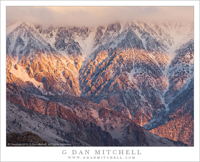
Dawn light on rugged Wheeler crest following an autumn Sierra Nevada snow storm.
It had snowed all day the previous day, and I knew that the eastern escarpment of the Sierra would be covered in new snow at dawn. The dawn weather conditions were a bit of an unknown, but it seemed to be worthwhile to get up very early and be in position with a view of the crest at sunrise, so we headed up into the hills above Bishop and below the mountains to see what would happen.
There were clouds. This can be a good thing or a bad thing in this situation. Without clouds the light can be less special, but if there are too many, especially to the east, they may completely block the sunrise light – and that light on the eastern face of the range is what we were there for. There was some clear sky overhead, and it seemed that the clouds to the east over the White Mountains were at least somewhat broken. These conditions bring the possibility – but not the certainty – that the dawn sun may find its way through gaps in the clouds, spotlighting areas of the mountains as the light works its way across and down their east faces. In fact, it worked out this way. We first photographed the range straight on, mostly centering compositions around Mt. Humphreys. After shooting that subject I looked around a bit more and saw bands of light starting to sweep across the face of the cloud-topped and rugged Wheeler Crest.
G Dan Mitchell is a California photographer and visual opportunist whose subjects include the Pacific coast, redwood forests, central California oak/grasslands, the Sierra Nevada, California deserts, urban landscapes, night photography, and more. Blog | About | Flickr | Twitter | Facebook | Google+ | 500px.com | LinkedIn | Email
Photographer and visual opportunist. Daily photos since 2005, plus articles, reviews, news, and ideas.
Manage Consent
To provide the best experiences, we use technologies like cookies to store and/or access device information. Consenting to these technologies will allow us to process data such as browsing behavior or unique IDs on this site. Not consenting or withdrawing consent, may adversely affect certain features and functions.
Functional
Always active
The technical storage or access is strictly necessary for the legitimate purpose of enabling the use of a specific service explicitly requested by the subscriber or user, or for the sole purpose of carrying out the transmission of a communication over an electronic communications network.
Preferences
The technical storage or access is necessary for the legitimate purpose of storing preferences that are not requested by the subscriber or user.
Statistics
The technical storage or access that is used exclusively for statistical purposes.The technical storage or access that is used exclusively for anonymous statistical purposes. Without a subpoena, voluntary compliance on the part of your Internet Service Provider, or additional records from a third party, information stored or retrieved for this purpose alone cannot usually be used to identify you.
Marketing
The technical storage or access is required to create user profiles to send advertising, or to track the user on a website or across several websites for similar marketing purposes.

 G Dan Mitchell is a California photographer and visual opportunist whose subjects include the Pacific coast, redwood forests, central California oak/grasslands, the Sierra Nevada, California deserts, urban landscapes, night photography, and more.