Tag Archives: summit

Beaver Pond, McGee Creek

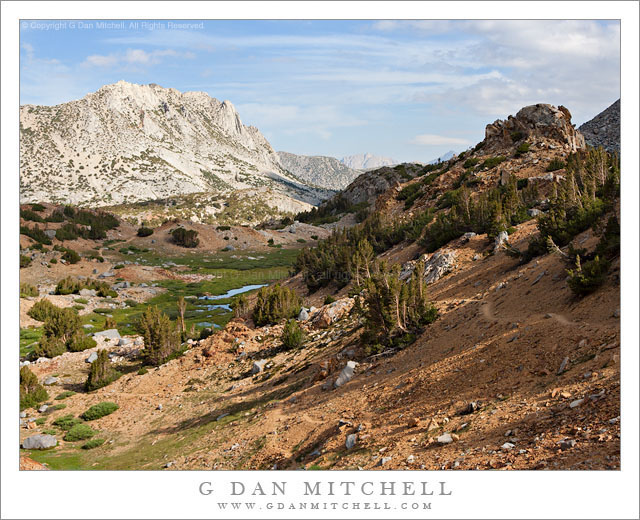
Beaver Pond, McGee Creek - A beaver pond floods a low area of McGee Creek below the peaks at the edge of Pioneer Basin.
A beaver pond floods a low area of McGee Creek below the peaks at the edge of Pioneer Basin.

Beaver Pond, McGee Creek. Eastern Sierra Nevada, California. September 16, 2012. © Copyright 2012 G Dan Mitchell – all rights reserved.

A beaver pond floods a low area of McGee Creek below the peaks at the edge of Pioneer Basin.

Unlike some so-called beaver ponds in the Sierra, this one really does appear to be the home  of beavers. If you look closely near the far bank of the pond, just left of center, you can see the distinctive peaked beaver den.

This spot was a bit of a landmark on the trail up McGee Canyon on my mid-September backpack trip to Steelhead Lake. Before this the trail mostly crossed relatively dry and open terrain, but starting at this point there was more forest cover, and the valley gradually began to become more rocky and narrower. There is just a bit of early fall color in this photograph. The plants around the pond have obviously gone brown, and  some of the aspens and other brush ascending the slopes of the canyon are just barely beginning to change – what I sometimes call the “lime green” stage where it starts to become clear that the real color change is not far away. The distant tall ridge marks the boundary between the McGee Creek drainage and Pioneer Basin. I’m not positive, but I think that the two high points on the ridge might be Mounts Stanford and Crocker,  part of a group of four peaks ringing Pioneer Basin that are named after the four “railroad barons, the other two being Huntington and Hopkins.

Unlike most of my mountain photographs, this was essentially a handheld “snap” – though made with a good camera and lens. When I’m hiking I carry my camera and two lenses in a chest strap mounted front carrier so that I can make some photographs while on the move without having to remove my pack. This sort of shot, made at a time of less than optimum light, is an example of the sort of thing that I’ll occasionally shoot that way.

G Dan Mitchell is a California photographer whose subjects include the Pacific coast, redwood forests, central California oak/grasslands, the Sierra Nevada, California deserts, urban landscapes, night photography, and more.
Blog | About | Flickr | Twitter | FacebookGoogle+ | 500px.com | LinkedIn | Email

Text, photographs, and other media are © Copyright G Dan Mitchell (or others when indicated) and are not in the public domain and may not be used on websites, blogs, or in other media without advance permission from G Dan Mitchell.

Aspens and Sage

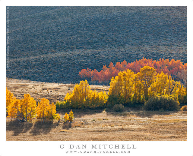
Aspens and Sage - Aspens grow against sage covered hills near Conway Summit in the eastern Sierra Nevada, California
Aspens grow against sage covered hills near Conway Summit in the eastern Sierra Nevada, California

Aspens and Sage. Eastern Sierra Nevada, California. October 16, 2011. © Copyright 2012 G Dan Mitchell – all rights reserved.

Aspens grow against sage covered hills near Conway Summit in the eastern Sierra Nevada, California.

If you want colorful aspen photographs, there are several things that may help. First, you need to be where the aspens are when they turn colors! (Obvious, huh?) In the eastern Sierra Nevada, this means roughly the first two weeks of October in a typical year, though you can often find some color a week or so either side of that period – but be aware that every aspen season is different, so there are no guarantees. And where are they? They can be found all up and down the east side of the Sierra. At their peak, you can find them by simply driving along highway 395 along the eastern slope of the range and looking west. For somewhat more specific information, take a look at this post of mine. Second, you’ll need to look around a bit for great trees. Photographs of aspen color can often make it seem like there is astonishing color everywhere – but the reality is often a bit more complicated. Trees will often be in various stages of transition, and the timing varies according to such things as elevation and local soil moisture. On top of that, not just any aspen trees will do – so you can count on doing a bit of searching to find that perfect tree or grove or colorful slope. Third, it helps a lot to consider the light. Often grove of trees that may look fairly drab when front lit can turn into an amazingly colorful wonder when the light comes toward you from behind the trees.

That is precisely what is happening in this photograph, taken at one of the well-known aspen color spots near Conway Summit just north of Lee Vining. On the right few days each fall, there are huge swaths of wonderful aspen color on the eastern slopes of the Sierra here. I often shoot here in the late afternoon, just before the sun drops behind the crest. This may mean that I’m shooting almost directly into the sun, but it also means that the leaves are brilliantly lit by light that comes from behind and passes through the leaves. This photograph captures a type of grove that always intrigues me, namely one that sits apart from the iconic alpine scenery and instead is in rangeland and sage brush country.

G Dan Mitchell is a California photographer whose subjects include the Pacific coast, redwood forests, central California oak/grasslands, the Sierra Nevada, California deserts, urban landscapes, night photography, and more.
Blog | About | Flickr | Twitter | FacebookGoogle+ | 500px.com | LinkedIn | Email

Text, photographs, and other media are © Copyright G Dan Mitchell (or others when indicated) and are not in the public domain and may not be used on websites, blogs, or in other media without advance permission from G Dan Mitchell.
The Watchman and the Virgin River, Morning

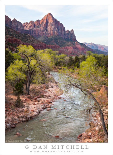
The Watchman and the Virgin River, Morning - The virgin River curves towards the Watchman in early morning light, Zion National Park, Utah.
The virgin River curves towards the Watchman in early morning light, Zion National Park, Utah.

The Watchman and the Virgin River, Morning. Zion National Park, Utah. April 4, 2012. © Copyright 2012 G Dan Mitchell – all rights reserved.

The virgin River curves towards the Watchman in early morning light, Zion National Park, Utah.

The peak in the upper portion of this photograph, The Watchman, with the curve of the Virgin River in the foreground is, as I understand it, one of the iconic photographic subjects of Zion National Park – perhaps being roughly equivalent to a photograph of Yosemite’s Half Dome from the Sentinel Bridge in The Valley. The funny thing, though, is that while I had seen this view of this subject many times in the photographs of others, I actually had no idea where it was or that I would see it when I visited Zion National Park earlier this month. I had somewhat intentionally avoided doing any real research about the places I would photograph, preferring instead to just confront them for what they are, unaffected as much as possible by previous notions about what I “should” photograph.

So, as we rode the shuttle bus into the park from the town of Springdale in the afternoon and crossed a bridge over the Virgin River before heading up into the canyon, I looked to my right and thought, “Oh, it is that view!” I have heard the stories and have seen the pictures of hordes of photographers lined up on this bridge, specifically to shoot this scene with fall colors and at sunset. (You can see a couple of examples by photographer and friend Gary Crabbe here.) I generally don’t seek out the icons, though I most certainly will photograph them if a) I haven’t photographed them before and/or b) there is something unusual or different about the conditions when I’m there. Although I did not stop and get off the bus to photograph the scene on that first evening, in the back of my mind I considered stopping if it looked interesting the next morning. And, in fact, as we took the shuttle back into the park very early the next morning – starting before sunrise, actually – it seemed like it might be worth hopping off after the bridge and taking a look. I was more encourage when we got there, both by the interesting soft dawn light and the lack of any other photographers on the bridge. So, there you go – I now have a photograph of the Watchman and the Virgin River, too! :-)

G Dan Mitchell is a California photographer whose subjects include the Pacific coast, redwood forests, central California oak/grasslands, the Sierra Nevada, California deserts, urban landscapes, night photography, and more.
Blog | About | Flickr | Twitter | FacebookGoogle+ | 500px.com | LinkedIn | Email

Text, photographs, and other media are © Copyright G Dan Mitchell (or others when indicated) and are not in the public domain and may not be used on websites, blogs, or in other media without advance permission from G Dan Mitchell.
East Side of Bishop Pass

East Side of Bishop Pass - Trail and meadows below the east side of Bishop Pass, eastern Sierra Nevada range
Trail and meadows below the east side of Bishop Pass, eastern Sierra Nevada range

East Side of Bishop Pass. Eastern Sierra Nevada, California. August 4, 2005. © Copyright 2005 G Dan Mitchell – all rights reserved.

Trail and meadows below the east side of Bishop Pass, eastern Sierra Nevada range.

This photograph comes from about a dozen years ago. I recently came across it while sorting through older photograph files for a variety of reasons – general clearing out of old images, searching for photographs of a particular subject for a client, and seeing what older images I might have missed when I first made them. When I saw this photograph it evoked a whole series of fun recollections.

Nearly weeks earlier, I had begun a two-week-long backpack trip along a section of the John Muir Trail. At that time, the only section of the JMT that I had not hiked (at least once!) was an area between approximately Shadow Lake and the Muir Trail Ranch – and this was to be the trip on which I covered this remaining bit of trail. The trip started just fine, though in some territory that is not exactly my favorite portion of the range – the low areas around Devils Postpile. After passing by that national monument we headed south, passing Duck Lake and camping at Purple Lake.

The next morning I woke up feeling a bit under the weather, an unusual experience for me on the trail. The next leg of the trip was to take us through an area without an easy exit, and I became concerned about what would happen if my “feeling poorly” deteriorated into actually being sick. I reluctantly decided to leave my group to continue without me, and I backtracked over Duck Pass and down into the Mammoth Lakes area and headed home. (Ironically, by the time I got out I was feeling fine…)

Ending a trip this way just didn’t feel right, so I hatched a plan to show up and run into my friends on the last day of their trip. Since they were coming out over Bishop Pass, I crossed that pass into beautiful Dusy Basin a day earlier, and on the next morning hiked down the canyon so that I could be casually sitting on a rock as they came up the trail from LeConte Canyon. I have rarely seen people as surprised as they were when they found me! After our reunion and joining them for their last trail night, the next morning we were up early to hike out over Bishop Pass. This photograph was made shortly after we crossed the pass and began our descent to the trailhead.

G Dan Mitchell is a California photographer whose subjects include the Pacific coast, redwood forests, central California oak/grasslands, the Sierra Nevada, California deserts, urban landscapes, night photography, and more.
Blog | About | Flickr | Twitter | FacebookGoogle+ | 500px.com | LinkedIn | Email

Text, photographs, and other media are © Copyright G Dan Mitchell (or others when indicated) and are not in the public domain and may not be used on websites, blogs, or in other media without advance permission from G Dan Mitchell.