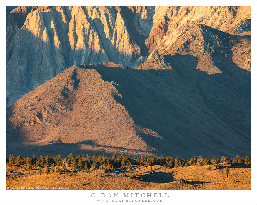
Tag Archives: valley

Panamint Valley and Mountains

Panamint Valley and Mountains
Looking into Panamint Valley and toward the Panamint Mountain Range

Panamint Valley and Mountains. Death Valley National Park, California. April 7, 2017. © Copyright 2017 G Dan Mitchell – all rights reserved.

Looking into Panamint Valley and toward the Panamint Mountain Range

When most people think of Death Valley they probably think of incredibly hot desert conditions. Those conditions are real, and are among the reasons that I do not visit the place during the warmer times of the year. But the conditions are quite a bit more varied than that reputation would suggest. I have been snowed on in Death Valley — on one memorable occasion photographic desert wildflowers in a snow storm! — and I have encountered temperatures ranging from over 100 degrees to below freezing. The variations are related to seasons (there are some very cold places here in the winter!) and to elevation, which ranges from below sea level to over 11,000′.

This photograph captures a range of those conditions in one image. It was a pleasantly warm, though cloudy, day as I left the park. The winds were howling down below in Panamint Valley, where a dust storm was beginning to kick up. Winter snow was still thick on the highest peaks of the Panamint range, and an incoming storm was developing and promising more precipitation.


G Dan Mitchell is a California photographer and visual opportunist. His book, “California’s Fall Color: A Photographer’s Guide to Autumn in the Sierra” is available from Heyday Books and Amazon.
Blog | About | Flickr | Twitter | FacebookGoogle+ | LinkedIn | Email


All media © Copyright G Dan Mitchell and others as indicated. Any use requires advance permission from G Dan Mitchell.

Panamint Valley, Wash

Panamint Valley, Wash
A large desert wash curves towards the Panamint Valley

Panamint Valley, Wash. Death Valley National Park, California. April 7, 2017. © Copyright 2017 G Dan Mitchell – all rights reserved.

A large desert wash curves towards the Panamint Valley

I always associate this view, of this canyon and the valley and mountains beyond, with leaving Death Valley. For many years I always access the park via the road up from Ridgecrest that passes through the desolate town of Trona, coming up the Panamint Valley before entering the park, either over Towne Pass or via Emigrant Pass and Wildrose Canyon. At some point I decided to take what I later determined to be the route favored by many other visitors, route 190 across to highway 395 at Olancha near the dry desolation of Owens Lake.

This view lies along that route. Shortly after leaving Panamint Valley the road passes up a bit of a canyon, crosses a ridge, and then tracks along the slopes paralleling this wash that runs out into Panamint Valley. The wash itself has a beautiful quality, curving gracefully around toward its arrival in the larger valley between the two dark, rounded hills. Across the Panamint Valley, at the base of the far mountains, there are sandy stretches which develop into full-blown dunes just a bit to the left of the area shown in the photograph. On this morning a weather from was coming in, producing some dramatic clouds above the Panamint Range.


G Dan Mitchell is a California photographer and visual opportunist. His book, “California’s Fall Color: A Photographer’s Guide to Autumn in the Sierra” is available from Heyday Books and Amazon.
Blog | About | Flickr | Twitter | FacebookGoogle+ | LinkedIn | Email


All media © Copyright G Dan Mitchell and others as indicated. Any use requires advance permission from G Dan Mitchell.

West From The Panamints

West From The Panamints
Early evening view looking west from ridge of the Panamint range, Death Valley National Park

West From The Panamints. Death Valley National Park, California. April 3, 2017. © Copyright 2017 G Dan Mitchell – all rights reserved.

Early evening view looking west from ridge of the Panamint range, Death Valley National Park

I made this photograph on the evening of my arrival in Death Valley. The drive is always a long one, taking most of the day when I come straight from the San Francisco Bay Area. This time I had started in the Carrizo Plains National Monument, where I had stopped overnight to join friends for some photography of this year’s extraordinary wildflower bloom. That meant that even though I had a slightly shorter drive I got a later start — I wasn’t about the leave the Carrizo without making some morning photographs, and then I explored a slower route through the Temblor Range on my way out to the Great Central Valley before continuing on to Death Valley.

My Death Valley plans were not set in stone, so when I arrived in the park I wasn’t quite sure where I would go the first night. I had some thoughts of heading out to a remote canyon area to camp, but given the late arrival I started to consider simply camping at Stovepipe Wells. When I got there and it looked like the wind might kick up a dust storm I changed my mind again and headed up into the Panamint Mountains. (Anyone who has endured a Stovepipe Wells dust storm will sympathize!) In any case, I set up a camp in the mountains and then headed out to this remote ridge top location, a place from which I have often photographed in the early morning. The haze was a bit thick looking to the east, but what a view there was to the west! In that direction the same haze glowed in the backlight of the evening sun with ridges receding into the distance and culminating at the crest of the Sierra Nevada.


G Dan Mitchell is a California photographer and visual opportunist. His book, “California’s Fall Color: A Photographer’s Guide to Autumn in the Sierra” is available from Heyday Books and Amazon.
Blog | About | Flickr | Twitter | FacebookGoogle+ | LinkedIn | Email


All media © Copyright G Dan Mitchell and others as indicated. Any use requires advance permission from G Dan Mitchell.

Ground, Fog, Birds, Sky

Ground, Fog, Birds, Sky
A flock of geese takes to the air above a fog bank at dawn

Ground, Fog, Birds, Sky. Great Central Valley, California. January 28, 2017. © Copyright 2017 G Dan Mitchell – all rights reserved.

A flock of geese takes to the air above a fog bank at dawn

This might seem almost like a photograph of nothing, but I don’t see it quite that way. Arriving very early on a winter morning at one of my favorite bird areas in the Central Valley, I found it quite foggy. It wasn’t so foggy that I couldn’t see, but the atmosphere near the ground was opaque enough to limit my view to perhaps a few hundred feet, especially along the ground that was shrouded by this tule fog.

Before long a huge flock of geese lifted off from behind the low fog and streamed across by view from one side to the other, just about the fog cloud. Because of the distance to the birds their cries were muted and, oddly, everything seemed almost still and quiet even as what may have been thousands of birds were in the air. My idea for this photograph is to make it into a very large print, where the layers may have an imposing scale reminiscent of actually being there.


G Dan Mitchell is a California photographer and visual opportunist. His book, “California’s Fall Color: A Photographer’s Guide to Autumn in the Sierra” is available from Heyday Books and Amazon.
Blog | About | Flickr | Twitter | FacebookGoogle+ | LinkedIn | Email


All media © Copyright G Dan Mitchell and others as indicated. Any use requires advance permission from G Dan Mitchell.