Tag Archives: afternoon

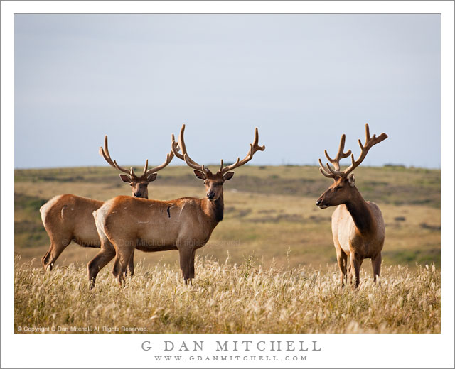
Three Elk, Point Reyes

Three Elk, Point Reyes

Three Elk, Point Reyes. Point Reyes National Seashore, California. May 30, 2011. © Copyright G Dan Mitchell – all rights reserved.

Three tule elk grazing on hills above Drakes Beach at Point Reyes National Seashore, California.

This is one more – and possibly the last – in the series of tule elk photographs that I made at the Point Reyes National Seashore on Memorial Day. A group of perhaps eight or ten bull elk were grazing along the top of the hills above Drakes Bay when we encountered them in beautiful late afternoon light. As soon as I got out with my camera they moved just a bit further away, but still well within photography range.

There is a typical sequence in how I usually photograph creatures such as these. Because I never know how long they will stick around, I begin my just shooting them in any way that seems even somewhat interesting, perhaps muttering to myself, “At least I have tule elk shots in my portfolio now!” But after getting a few “insurance” shots right off the bat, I start to be more selective and more observant. Initially, I’m looking for a variety of interesting individual shots. These might include a single animal separate from the group, perhaps the full group, and perhaps sub-groups of two or three. I also pay a lot of attention to their positions, watching to make sure that faces are visible. (In this shot, the leftmost elk is partially obscured, but because his eyes are still visible and because of the way his antlers align with those of the front animal, on balance I don’t think this is a big problem.) I also watch for distracting elements, and may stop shooting if they are present. For example, the rear end of an elk is bright white and, uh, not the most photogenic part of the beast – so I wait until an animal presenting its backside to the camera either moves out of the frame or rotates into a better position.

I also try to think the same way I think when photographing a group of people. Their faces and eyes are the most important things, with the relationships their positions create among them being a very close second. Here two of the elk are looking almost at me, but slightly past my left shoulder. The third animal seems to be looking more toward the other two, creating a different sort of relationship among the animals. These things are so fleeting that I sometimes don’t see them until they have happened, so I have learned to not be conservative about exposing a lot of frames!

To the extent that I have control over such things, I also like to think about the angle of the light on the subjects. Sometimes you have no choice – you simply have to shoot from where you are. However, with these elk I did have some range of options. They were along a road, and I chose to stop a bit before their position because the light coming from the left would light them in a more dramatic and interesting fashion than if I had gotten closer and shot them with the light right behind me. In addition, I try to look beyond the animals themselves and be aware of how they position themselves against background subjects. This particular shot isn’t a great example, but in others I might wait for the moving animals to position themselves in a place where the background elements relate to them in some interesting way.

With all of this detail, you might get the idea that I’m standing there making a series of careful and logical calculations about how to shoot these guys. That’s not really what happens at all. Much of it turns out to happen in a quick and intuitive and almost subconscious manner “in the moment.” I’ve probably written here before about my belief in the important of “practice” (something I learned from my musical background) when it comes to being able to work and see quickly and effectively.

G Dan Mitchell Photography | Flickr | Twitter (follow me) | Facebook (“Like” my page) | LinkedIn | Email
Text, photographs, and other media are © Copyright G Dan Mitchell (or others when indicated) and are not in the public domain and may not be used on websites, blogs, or in other media without advance permission from G Dan Mitchell.

Mesquite Dunes and Cottonwood Mountains

Mesquite Dunes and Cottonwood Mountains

Mesquite Dunes and Cottonwood Mountains. Death Valley National Park, California. March 29, 2011. © Copyright G Dan Mitchell – all rights reserved.

Soft and hazy late-afternoon light on Mesquite Dunes and lower Cottonwood Mountains, Death Valley National Park.

The color of the sand dunes of Death Valley changes radically at different times of the day, in different weather conditions, and even seasonally. Many of the photographs of these dunes – the “Mesquite Dunes” in the middle Valley near Stovepipe Wells – are made in the early morning or in the evening. At those times the dunes take on the colors of sunrise/sunset light (generally very warm yellow to golden colors) or the pre-dawn or (better yet) post-sunset light of the sky, which can include a range of colors from blues to pinks to purples and so on. Judging by photographs you might think that the dunes are brightly and intensely colorful. (Or black and white, but that’s a different story.)

Most of the time the coloration is quite different from what we see at the early and late “edges” of the day. The less saturated colors at other times of day can be a bit more complicated to shoot, but they can also create some wonderful subtle effects if you happen to look in the right place at the right time. Late in the afternoon on this early spring day, there was some haze in the atmosphere – perhaps from some blowing dust and/or some clouds and moisture that had been around earlier. As the sun drops at Mesquite Dunes, it goes behind mountains to the west well before actual sunset. When this happens, the dunes are gently back-lit by soft light from the western sky, and the backlit haze mutes the colors of the dunes and, even more, the distant slopes of the rugged Cottonwood Mountains.

My idea here was to isolate the undulating shapes of the softly lit dunes in front of the background of the very, very muted colors and shapes of the lower Cottonwood Mountains, which are obscured by haze. There is some color in this scene, but it is subdued and edges quite a ways towards pastels.

G Dan Mitchell Photography | Flickr | Twitter | Facebook | Email
Text, photographs, and other media are © Copyright G Dan Mitchell (or others when indicated) and are not in the public domain and may not be used on websites, blogs, or in other media without advance permission from G Dan Mitchell.

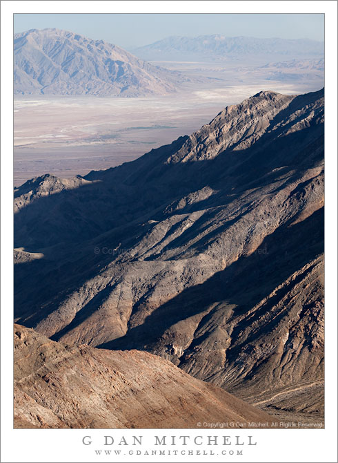
Trail Canyon, Lower Slopes of Wildrose Peak, Death Valley

Trail Canyon, Lower Slopes of Wildrose Peak, Death Valley

Trail Canyon, Lower Slopes of Wildrose Peak. Death Valley National Park, California. March 30, 2011. © Copyright G Dan Mitchell – all rights reserved.

Afternoon shadows fall across the lower slopes of Wildrose Peak above Trail Canyon and below Aguereberry Point, with Death Valley and the Black Mountains beyond.

The view from Aguereberry Point (and from this location close to the point) is spectacular and expansive, taking in everything from Death Valley itself, stretching almost 180 degrees from left to right, to the Green, Black, and other mountains beyond. To the south and north other ranges merge with the atmospheric haze. The peaks of the Panamint range lie behind, and in places where the view is clear you can look down on the rugged terrain of the east face of the Panamint Range with its rugged ridges and deep canyons dropping towards the Valley. This photograph looks roughly southeast towards the lower end of Death Valley in the area around Ashford Mill. The deep foreground canyon, the bottom of which is just visible at lower right, is Trail Canyon. I understand that a four-wheel-drive road used to come up to Aguereberry Point via that canyon, but that parts have washed out and it can no longer be driven. I think that you can hike it, but that would be one heck of a climb since the base of the canyon can’t be more than a few hundred feet above Death Valley (which is below sea level in this area) and the Point is well above 6000′. The lower slopes of Wildrose Peak rise beyond the canyon.

Surprisingly, this view presents several photographic challenges. Because of the haze that appears when such great distances are part of the scene, I chose to use a polarizing filter for this shot. Timing is important here, too. Arrive a bit too early and the light is harsh and flat. Arrive a bit too late and the foreground ridges are quickly enveloped in shadows as the sun drops behind the crest of the Panamint Range. (Yes, I have made both mistakes in the past.) Knowing this, I arrived a bit earlier than I might have usually arrive to shoot evening light and I managed to photograph the scene before that Panamint Range shadow obliterated the foreground light.

G Dan Mitchell Photography | Flickr | Twitter | Facebook | Email
Text, photographs, and other media are © Copyright G Dan Mitchell (or others when indicated) and are not in the public domain and may not be used on websites, blogs, or in other media without advance permission from G Dan Mitchell.
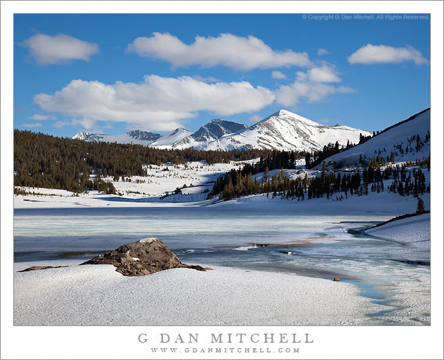
Tioga Lake, Late Spring

Tioga Lake, Late Spring

Tioga Lake, Late Spring. Near Yosemite National Park, California. June 5, 2010. © Copyright G Dan Mitchell – all rights reserved.

Late spring at icebound Tioga Lake below Tioga Pass with Mammoth Peak and the Kuna Crest beyond in afternoon light.

I made and shared a slightly different photograph of this scene last summer, but when I did my annual end-of-year traverse of the year’s raw files I returned to the original set of images and wondered how I missed this one. In a lot of ways it is similar to the one I selected earlier, though the foreground light and shadow patterns are a bit different and, more importantly, I like the position of the clouds in this one more than what I had in the original. So, there are now two versions of this scene floating around…

After several fairly dry years in California, the winter of 2009-10 produced much more precipitation, as rain in the lowlands and as snowpack in the Sierra. Because of the heavier snow, Tioga Pass opened just a bit later than average, and when it opened there was still a lot of snow in the high country. Since this afforded a rare chance to cross the Yosemite Sierra in conditions not usually seen by drivers I made it a point to get up there as soon as the road opened.

On the drive there was snow along almost the entire length of Tioga Pass Road, and in many places it looked more like winter than like spring. At the same time, it was spring, and the melting of the snowpack was fully underway. While lakes like Tioga Lake, as seen in this photograph, were still ice-covered… the ice was thinning quickly, and everywhere the melting snow was creating creeks and cascades. The high country, especially at the elevation of the road, was filling with water – water in ponds, water in overflowing lakes, water in rivers, water in cascades and waterfalls. I was waterfalls along the road in places where I had not even suspected that there were creeks!

This photograph shows Tioga Lake, just east of and below Tioga Pass, the eastern entrance to Yosemite. The pass itself is in the low saddle just above the meadow ascending the hill at the end of the lake. Beyond, and inside the park, is massive Kuna Crest with white, snow-capped Mammoth Peak in full sun at the right end of the ridge.

G Dan Mitchell Photography | Flickr | Twitter | Facebook | Email
Text, photographs, and other media are © Copyright G Dan Mitchell (or others when indicated) and are not in the public domain and may not be used on websites, blogs, or in other media without advance permission from G Dan Mitchell.