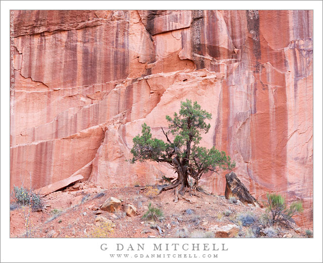
Tag Archives: cliff

Maple Leaves, Cliff

Maple Leaves, Cliff
Maple Leaves, Cliff

Maple Leaves, Cliff. Zion National Park, Utah. October 22, 2012. © Copyright 2012 G Dan Mitchell – all rights reserved.

Yellow autumn maple leaves against a sandstone cliff face, Zion National Park.

When I think of Zion National Park, a few sorts of scenes come immediately to mind – red cliffs, curving and rounded patterns of colored sandstone… and trees against the sandstone walls. During my 2012 visits to the park I had ample opportunities to photograph the latter subject – new spring cottonwood growth against the rock in early April, maples in the park’s high country in early October, and then more maples in both the high and low areas near the end of the period.

I photographed these brilliant yellow leaves in the high country along the Mount Carmel highway, on one of my walks away from the road down into the bottom of the canyon where the rocks close in and these trees grow, tucked along the edge of waterways or into small areas up against the rocks. The colors of the trees in these often-quiet places range across almost the entire spectrum of fall color – from unchanged green leaves and some lime green leaves just beginning the transition, through red and orange to this this golden-yellow, and finally to the dull browns of fallen leaves.

G Dan Mitchell is a California photographer and visual opportunist whose subjects include the Pacific coast, redwood forests, central California oak/grasslands, the Sierra Nevada, California deserts, urban landscapes, night photography, and more.
Blog | About | Flickr | Twitter | FacebookGoogle+ | 500px.com | LinkedIn | Email

Text, photographs, and other media are © Copyright G Dan Mitchell (or others when indicated) and are not in the public domain and may not be used on websites, blogs, or in other media without advance permission from G Dan Mitchell.

Sandstone Tower, Fruita District

Sandstone Tower, Fruita District

Sandstone Tower, Fruita District. Capitol Reef National Park, Utah. October 8, 2012. © Copyright 2012 G Dan Mitchell – all rights reserved.

A sandstone tower stands above the Fruita District orchards in early evening light, Capitol Reef National Park

These sandstone plateaus and mesas seem characteristic of this front-country area of Capitol Reef National Park, and they are perhaps the most striking visual icon of your approach to the park from the town of Torrey, Utah, to the west. The Fruita District is the most accessible area of the park, being right alongside the main east-west highway that passes through the park. It features some picturesque sites and sights that are enough to make almost anyone pull over and look, including the old orchards that apparently gave the area its name and the accessible petroglyphs on low cliffs that run along the road. (Although this portion of the park is quite accessible once you are out here and driving across Utah, most of the park is anything but easily accessible, and getting to other places within its boundaries can involve some very long drives on some fairly bad roads, plus some hiking. I’m fine with that! ;-)

I made this photograph late in the day, after we had done a bit of exploring along the main tourist route into the park, the largely paved road towards Capitol Gorge and other nearby points. Late in the day I happened to spot this little conjunction of creek and fall-color tree and green grass and red rock cliffs as we were about to leave the park.

G Dan Mitchell is a California photographer and visual opportunist whose subjects include the Pacific coast, redwood forests, central California oak/grasslands, the Sierra Nevada, California deserts, urban landscapes, night photography, and more.
Blog | About | Flickr | Twitter | FacebookGoogle+ | 500px.com | LinkedIn | Email

Text, photographs, and other media are © Copyright G Dan Mitchell (or others when indicated) and are not in the public domain and may not be used on websites, blogs, or in other media without advance permission from G Dan Mitchell.

Cottonwood Grove and Cliff, Autumn

Cottonwood Grove and Cliff, Autumn - A cottonwood grove in golden fall colors, Grand Staircase-Escalante National Monument
A cottonwood grove in golden fall colors, Grand Staircase-Escalante National Monument

Cottonwood Grove and Cliff, Autumn. Grand Staircase-Escalante National Monument, Utah. October 24, 2012. © Copyright 2012 G Dan Mitchell – all rights reserved.

A cottonwood grove in golden fall colors, Grand Staircase-Escalante National Monument

In late October these bright yellow-gold cottonwood trees seem to be almost everywhere in Utah, albeit at slightly different stages of color development. Some are still mostly green with just a hint of yellow, while others have lost most of their leaves. From what I can tell, the difference in the pattern of change relate to things such as elevation, whether the trees are in sheltered canyons – in Zion Canyon they seem to change much later – or out in the open, and other causes that I don’t yet understand. One thing I do know: Between the aspens, which change color several weeks earlier, and the cottonwoods it seems like the entire month of October produces a lot of fall color. From what I hear it even extends into November, though I haven’t been there during that month to see it for myself.

On this day we began early with very cold hike into a portion of the Escalante River, which runs for quite a good distance through this section of Utah. Before the day was over we were challenged by strong wind, more cold, and eventually even a bit of light rain, but early on when I made this photograph the conditions were still bit less challenging, at least as far as the wind was concerned. Here the water course ran very close to the cliff wall, and clumps of golden cottonwoods grew between the water and the sandstone face. Although some direct light was beginning to strike the upper canyon walls and reflect light down into the canyon, here at the bottom along the creek the light was still soft and diffused.

G Dan Mitchell is a California photographer whose subjects include the Pacific coast, redwood forests, central California oak/grasslands, the Sierra Nevada, California deserts, urban landscapes, night photography, and more.
Blog | About | Flickr | Twitter | FacebookGoogle+ | 500px.com | LinkedIn | Email

Text, photographs, and other media are © Copyright G Dan Mitchell (or others when indicated) and are not in the public domain and may not be used on websites, blogs, or in other media without advance permission from G Dan Mitchell.

Colorado River, Dead Horse Point

Colorado River, Dead Horse Point

Colorado River, Dead Horse Point. Deadhorse Point State Park, Utah. October 10, 2012. © Copyright 2013 G Dan Mitchell – all rights reserved.

The canyon of the Colorado River, from Dead Horse Point State Park, Utah

The light was a bit tricky when we drove out to Dead Horse Point to look at the famous view of the Colorado River as it loops below huge cliffs at the edge of Canyonlands National Park in Utah. It was nearing the middle of the day, so the soft morning and evening light was nowhere to be found. It was also hazy, with the slightly opaque air taking on distinctly blue colors. For all of these reasons, and also perhaps as a nod to old school landscape photography, I went with a black and white rendition of this photograph.

This is a truly remarkable bit of terrain. First, in the bottom of the canyon the Colorado River negotiates and abrupt horseshoe bend here beneath the tall cliffs leading up to the “Island in the Sky” portion of Canyonlands National Park. Above the river are a series of huge terraces form as the river eroded its way though the deep and old layers of sedimentary rock that characterize this area. Shooting with a slightly long focal length, I was able to eliminate most extraneous subjects and crop tightly around this area of massive cliffs and terraces.

G Dan Mitchell is a California photographer and visual opportunist whose subjects include the Pacific coast, redwood forests, central California oak/grasslands, the Sierra Nevada, California deserts, urban landscapes, night photography, and more.
Blog | About | Flickr | Twitter | FacebookGoogle+ | 500px.com | LinkedIn | Email

Text, photographs, and other media are © Copyright G Dan Mitchell (or others when indicated) and are not in the public domain and may not be used on websites, blogs, or in other media without advance permission from G Dan Mitchell.