Tag Archives: flats

Trail Canyon, Lower Slopes of Wildrose Peak, Death Valley

Trail Canyon, Lower Slopes of Wildrose Peak, Death Valley

Trail Canyon, Lower Slopes of Wildrose Peak. Death Valley National Park, California. March 30, 2011. © Copyright G Dan Mitchell – all rights reserved.

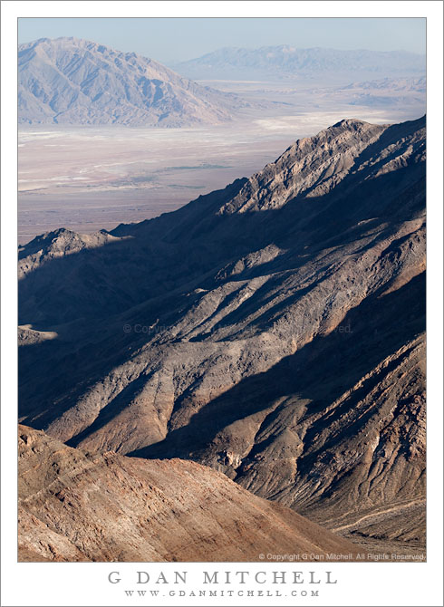
Afternoon shadows fall across the lower slopes of Wildrose Peak above Trail Canyon and below Aguereberry Point, with Death Valley and the Black Mountains beyond.

The view from Aguereberry Point (and from this location close to the point) is spectacular and expansive, taking in everything from Death Valley itself, stretching almost 180 degrees from left to right, to the Green, Black, and other mountains beyond. To the south and north other ranges merge with the atmospheric haze. The peaks of the Panamint range lie behind, and in places where the view is clear you can look down on the rugged terrain of the east face of the Panamint Range with its rugged ridges and deep canyons dropping towards the Valley. This photograph looks roughly southeast towards the lower end of Death Valley in the area around Ashford Mill. The deep foreground canyon, the bottom of which is just visible at lower right, is Trail Canyon. I understand that a four-wheel-drive road used to come up to Aguereberry Point via that canyon, but that parts have washed out and it can no longer be driven. I think that you can hike it, but that would be one heck of a climb since the base of the canyon can’t be more than a few hundred feet above Death Valley (which is below sea level in this area) and the Point is well above 6000′. The lower slopes of Wildrose Peak rise beyond the canyon.

Surprisingly, this view presents several photographic challenges. Because of the haze that appears when such great distances are part of the scene, I chose to use a polarizing filter for this shot. Timing is important here, too. Arrive a bit too early and the light is harsh and flat. Arrive a bit too late and the foreground ridges are quickly enveloped in shadows as the sun drops behind the crest of the Panamint Range. (Yes, I have made both mistakes in the past.) Knowing this, I arrived a bit earlier than I might have usually arrive to shoot evening light and I managed to photograph the scene before that Panamint Range shadow obliterated the foreground light.

G Dan Mitchell Photography | Flickr | Twitter | Facebook | Email
Text, photographs, and other media are © Copyright G Dan Mitchell (or others when indicated) and are not in the public domain and may not be used on websites, blogs, or in other media without advance permission from G Dan Mitchell.

Last Light on Desert Plants, Death Valley

Last Light on Desert Plants, Death Valley

Last Light on Desert Plants, Death Valley. Death Valley National Park, California. February 20, 2011. © Copyright G Dan Mitchell – all rights reserved.

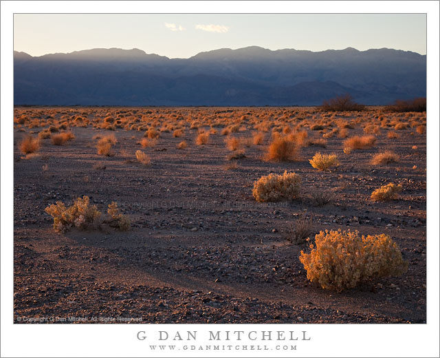
The last light of a winter day lights the plants at the edge of a wash in Death Valley National Park, California.

On this afternoon I drove a bit up the east side of the Valley past the turnoff to Beatty looking for subjects to shoot along the hills that parallel the valley. I did not initially have a specific shot in mind, since this isn’t an area that I know very well – I’ve mostly driven past it on my way to some other place. I was generally thinking of a couple of possibilities. One was an early evening photograph looking up into one of the very large canyons, probably include the massive washes that spill out of them and aiming for a very rugged looking image. I looked for a few such places and played around a bit with the idea of shooting one or two, but it wasn’t quite working for me.

I have included some low hills along this area called, I believe, the Kit Fox Hills, in some photographs that I have made of this area from way over near Mesquite Dunes. These hills which sit just above the road toward Scotty’s Castle have intrigued me, so I had also looked at them. As I passed them earlier in the afternoon I made a mental note to come back and check out one particular spot in better light, and when the canyon idea didn’t seem to work out I decided to head back there. I was probably a bit late in settling on this subject, but I arrived while the sun was still (just barely) above the tops of the ridges on the opposite side of the Valley. I grabbed equipment and went to a spot where I thought I could use a particular mesquite plant as foreground to a shot of these low hills, but then this backlit expanse of the floor of the Valley filled with these small, rugged plants caught my attention. I decide to photograph them before turning my attention back to the mesquite and hills. As I shot a few frames the sun began to drop behind the far hills much sooner than I expected, and this was close to the last photograph I made before I was in shadow.

All seriousness aside, someone just suggested that an alternate title for this photograph might be “Sea of Tribbles!” ;-)

G Dan Mitchell Photography | Flickr | Twitter | Facebook | Email
Text, photographs, and other media are © Copyright G Dan Mitchell (or others when indicated) and are not in the public domain and may not be used on websites, blogs, or in other media without advance permission from G Dan Mitchell.
Dunes, Cottonwood Mountains, and Dust Storm

Dunes, Cottonwood Mountains, and Dust Storm

Dunes, Cottonwood Mountains, and Dust Storm. Death Valley National Park, California. February 19, 2011. © Copyright G Dan Mitchell – all rights reserved.

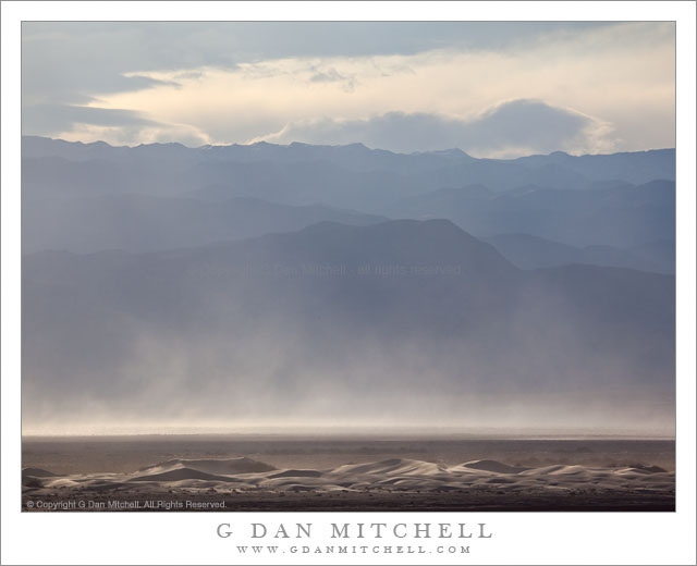
Afternoon winds whip up a dust storm over Death Valley between sand dunes and the high ridges of the Cottonwood Mountains.

Following my typical routine of “get up ridiculously early and shoot until I can’t stand it any longer, hang out during the middle of the day, and then head out for late afternoon and evening shooting,” I had been watching some interesting clouds developing far to the north of Stovepipe Wells during the day and decided that I might head up that way in the evening if they continued to hold promise. After crossing the Valley to the Scotty’s Castle road junction I could see a curtain of virga falling from those clouds to the north, so I decided to head that way.

The wind had been picking up from the south during the afternoon as another weather front approached. As I headed up along the edge of the main valley I could see that this wind was starting to pick up dust and sand from the Mesquite Dunes area near Stovepipe and from areas just north of that. I’m more familiar with the dust being carried south by winds out of the north, so this was a bit of a different site as sand/dust were being picked up from the dunes rather than being deposited there.

The dunes at the bottom of this photograph are not the familiar “main” dunes near Stovepipe, but are instead smaller dunes running north/south up the Valley. While a larger version of the photograph shows some blowing dust on these foreground dunes, the main cloud is coming from further south down the Valley. Beyond the dust and across the Valley are the hills of the Cottonwood range ascending to a ridge that still holds a bit of snow from storms over the previous couple of days, with building clouds above that would bring another dusting on this evening.

G Dan Mitchell Photography | Flickr | Twitter | Facebook | Email
Text, photographs, and other media are © Copyright G Dan Mitchell (or others when indicated) and are not in the public domain and may not be used on websites, blogs, or in other media without advance permission from G Dan Mitchell.
Clouds at Last Light – Badwater Basin and Panamint Range

Clouds at Last Light - Badwater Basin and Panamint Range

Clouds at Last Light – Badwater Basin and Panamint Range. Death Valley National Park, California. March 29, 2010. © Copyright G Dan Mitchell – all rights reserved.

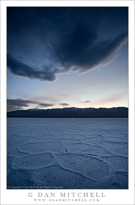
Last light of the day over the Panamint Range casts its glow on Badwater Basin salt flats and clouds.

In what may be the last gasp of my obvious attempt to extract as many photographs as possible from this late March evening in Badwater Basin, here is yet another. This one was photographed well after the sun had set, and I had turned my camera away from the expansive view north into Death Valley and to the east towards the Panamint Range and Telescope Peak over which I saw this wing-shaped cloud. While there was a thin band of relatively bright sky above the Panamint Range, everything else was heading quickly toward twilight. (The longer exposures listed in the “technical data” below will confirm the light levels.)

I’ve previously mentioned the subjective issue of how to handle the very blue tone of the “white” salt formations here. The salt is, no doubt, really white – but after the sun dips below the Panamint Range the only light is that of the very blue sky, and the salt picks this up. If you think about it you can see it on the scene, but when you look at the photographs later it is absolutely clear. I’ve been thinking for several weeks about how I’d handle this one, and I decided over a week ago that I’d “go for the blue” with this rendition.

This photograph is not in the public domain and may not be used on websites, blogs, or in other media without advance permission from G Dan Mitchell.
G Dan Mitchell Photography | Twitter | Friendfeed | Facebook | Facebook Fan Page | Email

Technical Data:
Canon EOS 5D Mark II
Canon EF 17-40mm f/4 L USM at 17mm
ISO 100, f/16, composite of .8 second and 1.3 second exposures

keywords: panamint, mountain, range, badwater, basin, salt, flats, polygons, desert, death valley, national, park, california, usa, north america, landscape, travel, scenic, dusk, twilight, sunset, cloud, large, dark, sky, nature, blue, evening, pink, stock, pattern