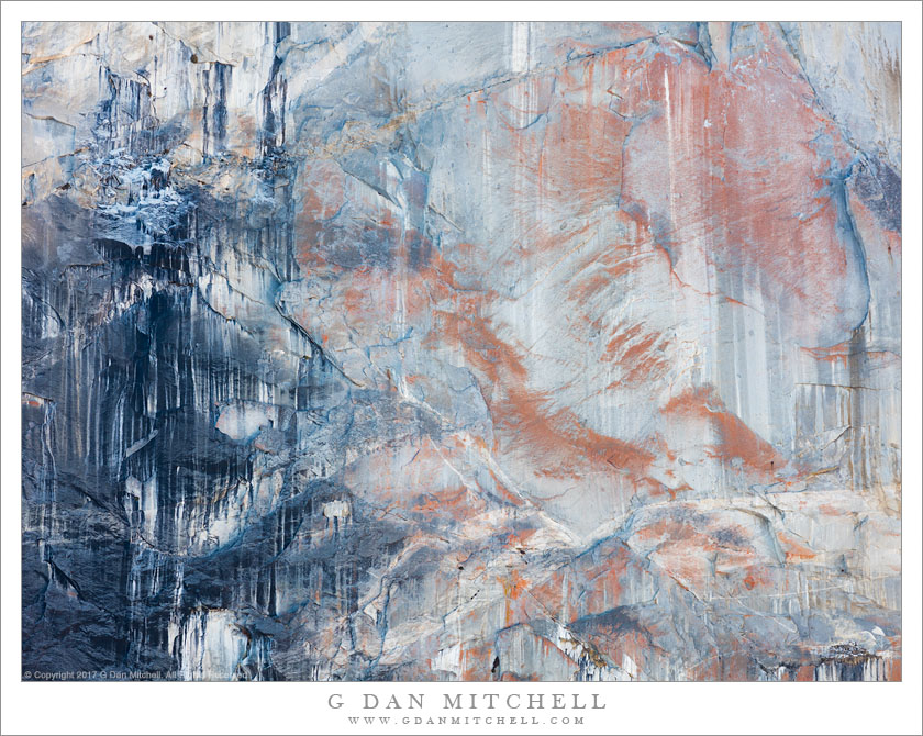
Tag Archives: geology

Canyon Narrows

Canyon Narrows
Twisting narrows in a desert canyon, Death Valley

Canyon Narrows. Death Valley National Park, California. April 30, 2016. © Copyright 2016 G Dan Mitchell – all rights reserved.

Twisting narrows in a desert canyon, Death Valley

On a late spring day of wind and sand storms in Death Valley National Park — and after several days of such conditions — we retreated to one of the deep and narrow desert canyons for an afternoon. After a short walk across the upper edges of a giant alluvial fan, we dropped into the lower reaches of the canyon and headed uphill. Soon the path entered the base of the range and the walls began to narrow, and the wide open world of the desert floor was invisible to us.

The canyons of Death Valley are in some ways similar to the more famous slot canyons of the Southwest. Both are formed by water coursing down narrow canyons, sometimes at high rates that rearrange the geography of the canyons significantly. But there are differences. Here the canyons are most often dry — a year round water supply in such Death Valley places is not typical. And the rock is not the familiar red sandstone of the Southwest, but here a more contorted and broken and often less colorful rock. But sections are very beautiful, and there is something very magical about this section of this canyon, as it narrows and passed between inward curving walls.


G Dan Mitchell is a California photographer and visual opportunist. His book, “California’s Fall Color: A Photographer’s Guide to Autumn in the Sierra” is available from Heyday Books and Amazon.
Blog | About | Flickr | Twitter | FacebookGoogle+ | LinkedIn | Email


All media © Copyright G Dan Mitchell and others as indicated. Any use requires advance permission from G Dan Mitchell.

Canyon, Contorted Formations

Canyon, Contorted Formations
Contorted geologic formations along a narrow desert canyon

Canyon, Contorted Formations. Death Valley National Park, California. March 30, 2016. © Copyright 2016 G Dan Mitchell – all rights reserved.

Contorted geologic formations along a narrow desert canyon

Almost inevitably, one’s first impression of Death Valley National Park is that of huge open desert spaces, with salt flats, occasional dunes, and vast alluvial fans surrounded by rugged and arid mountain ranges. These things are impressive — that scale of the landscape reminds me of visits to The Yukon and Alaska — and the fact that roads run though and past them helps make them seem central. But with time to explore a bit more, it becomes clear that there is more to the landscape than first meets the eye. Among these features are the uncounted canyons that thread their way into the mountain ranges.

We visited a few of them during this year’s spring visit to the park, including this one that we hiked into one afternoon. The terrain of these canyons is remarkable variable, ranging from shallow and open to very narrow with vertical walls. This spot fits somewhere in the middle — the walls here are indeed very high, but they tilt back a bit from the vertical and allow a bit more light down to the gravel wash at the bottom. This particular section especially impressed me with the wildly contorted layers revealed in the cliff above. This spot is near the bottom of one of the ranges in the “basin and range” geology of the area, and the old strata are twisted and folded in all directions.


G Dan Mitchell is a California photographer and visual opportunist. His book, “California’s Fall Color: A Photographer’s Guide to Autumn in the Sierra” is available from Heyday Books and Amazon.
Blog | About | Flickr | Twitter | FacebookGoogle+ | LinkedIn | Email


All media © Copyright G Dan Mitchell and others as indicated. Any use requires advance permission from G Dan Mitchell.

Waterpocket Fold Terrain

Waterpocket Fold Terrain
Deep erosion gullies below an uplifted rock band empty into the valley below, with rugged terrain extending into the distance

Waterpocket Fold Terrain. Capitol Reef National Park, Utah. October 22, 2014. © Copyright 2014 G Dan Mitchell – all rights reserved.

Deep erosion gullies below an uplifted rock band empty into the valley below, with rugged terrain extending into the distance

Until a few years ago, although I had heard the term “waterpocket fold” before, I was almost completely unaware of what this geological feature is. Since that time I have visited it several times. On the first occasion I visited the area, but I still did not understand the geology. I “got it” that there was some sort of uplift — the land rising to the west of Capitol Reef was a pretty good clue — but I did not understand or really see any of the connections. I recall stopping at one road side pullout and seeing a sign about it, registering that it is something important, but not really understanding.

On more recent visits the reality of this huge and striking feature has finally sunk in. I began to see it a few years ago on a trip that took we away from main roads and way up on a rocky ridge from which I could look down into the eastern valley and clearly see some of the larger patterns — sinuous lines of angled rock, the valley twisting gently into the distance in the south. On the most recent visit it began to make a lot more sense, as I noticed features like the shadowed cliff band across the center of this photograph, which more or less represents the remaining underside of a layer that long ago continued on up into what today would be the sky. Its edge overhangs the softer material below, though it still erodes into the bottom of the valley. Further to the east in this photograph the impossibly rugged terrain of arid strata continues, eventually rising to a mountain range in the far distance.


G Dan Mitchell is a California photographer and visual opportunist. Blog | About | Flickr | Twitter | FacebookGoogle+ | 500px.com | LinkedIn | Email


All media © Copyright G Dan Mitchell and others as indicated. Any use requires advance permission from G Dan Mitchell.

Titus Canyon

Titus Canyon
Titus Canyon

Titus Canyon. Death Valley National Park, California. April 1, 2015. © Copyright 2015 G Dan Mitchell – all rights reserved.

Titus Canyon narrows, Death Valley National Park

In something of a departure for me… I have named a location. Enjoy it while it lasts! ;-) The lower portion of this canyon is one of the popular destinations in Death Valley National Park, and with good reason. This section is very narrow and deep, and aside from the lack of red colored rock it might remind one in some ways of similar canyons in other places such as the Southwest. There are essentially two ways to get to this section. More than once I’ve driven to the canyon entrance, loaded up a pack with camera gear and water, and walked in. This is a great way to experience the lower canyon, which is the area with the most impressive canyon walls and narrow sections. I always see much more when I’m on foot, and there are a lot of subtle things to look for in this part of the lower canyon.

The alternative way to get here involves a fair amount of driving on a road that is rough enough that it could make some drivers uncomfortable. (It is not a place for low-slung suburban vehicles, to be sure.) The one-way road through the canyon begins in the higher country of the Amargosa Valley near the eastern boundary of the park. It crosses the flat desert terrain as it heads toward the mountains and soon begins to twist and turn through valleys, up slopes, and over ridges. A few sections might test the nerves of drivers not used to such roads, especially the sections just before and after Red Pass. Once over the pass the road drops into the canyon and begins its descent toward the Valley. Near the end the road passes through the section that you could hike into from below, a section that seems like a very improbable place for an automobile roadway — and this photograph shows part of that segment of the trip.


G Dan Mitchell is a California photographer and visual opportunist whose subjects include the Pacific coast, redwood forests, central California oak/grasslands, the Sierra Nevada, California deserts, urban landscapes, night photography, and more.
Blog | About | Flickr | Twitter | FacebookGoogle+ | 500px.com | LinkedIn | Email

Text, photographs, and other media are © Copyright G Dan Mitchell (or others when indicated) and are not in the public domain and may not be used on websites, blogs, or in other media without advance permission from G Dan Mitchell.