
Tag Archives: geology

Titus Canyon

Titus Canyon
Titus Canyon

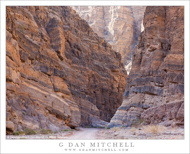
Titus Canyon. Death Valley National Park, California. April 1, 2015. © Copyright 2015 G Dan Mitchell – all rights reserved.

Titus Canyon narrows, Death Valley National Park

In something of a departure for me… I have named a location. Enjoy it while it lasts! ;-) The lower portion of this canyon is one of the popular destinations in Death Valley National Park, and with good reason. This section is very narrow and deep, and aside from the lack of red colored rock it might remind one in some ways of similar canyons in other places such as the Southwest. There are essentially two ways to get to this section. More than once I’ve driven to the canyon entrance, loaded up a pack with camera gear and water, and walked in. This is a great way to experience the lower canyon, which is the area with the most impressive canyon walls and narrow sections. I always see much more when I’m on foot, and there are a lot of subtle things to look for in this part of the lower canyon.

The alternative way to get here involves a fair amount of driving on a road that is rough enough that it could make some drivers uncomfortable. (It is not a place for low-slung suburban vehicles, to be sure.) The one-way road through the canyon begins in the higher country of the Amargosa Valley near the eastern boundary of the park. It crosses the flat desert terrain as it heads toward the mountains and soon begins to twist and turn through valleys, up slopes, and over ridges. A few sections might test the nerves of drivers not used to such roads, especially the sections just before and after Red Pass. Once over the pass the road drops into the canyon and begins its descent toward the Valley. Near the end the road passes through the section that you could hike into from below, a section that seems like a very improbable place for an automobile roadway — and this photograph shows part of that segment of the trip.


G Dan Mitchell is a California photographer and visual opportunist whose subjects include the Pacific coast, redwood forests, central California oak/grasslands, the Sierra Nevada, California deserts, urban landscapes, night photography, and more.
Blog | About | Flickr | Twitter | FacebookGoogle+ | 500px.com | LinkedIn | Email

Text, photographs, and other media are © Copyright G Dan Mitchell (or others when indicated) and are not in the public domain and may not be used on websites, blogs, or in other media without advance permission from G Dan Mitchell.
Fractured Slab

Fractured Slab
Fractured Slab

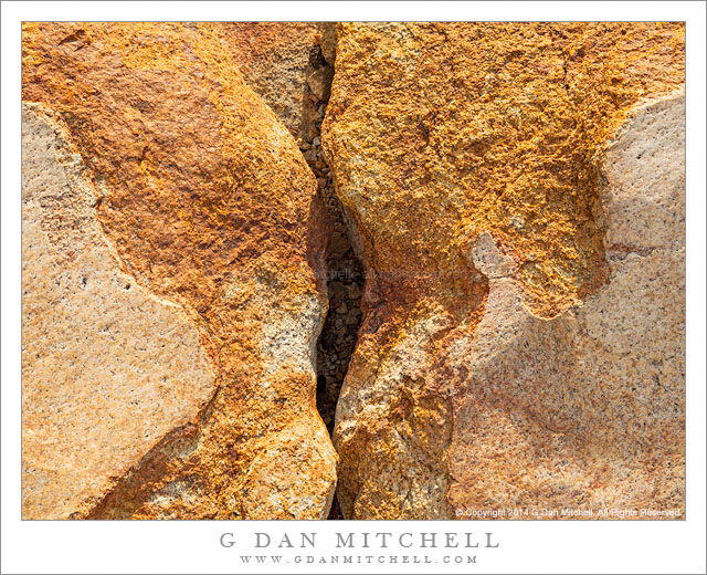
Fractured Slab. Yosemite National Park, California. September 7, 2014.© Copyright 2014 G Dan Mitchell – all rights reserved.

Stained and fractured rock slabs in the Yosemite National Park backcountry

This “intimate landscape” photograph of what is, objectively speaking, no more than a crack separating two pieces of granite actually tells a number of more interesting and complex stories. At least one of them is a story of the events of the day on which the photograph was made, while others are much older stories, bits of which can be seen in the rocks.

The story of this day involved wildfire. On the day we arrived at our camp in this area, the Yosemite “Meadow” fire took off in the area bounded roughly by Half Dome, Clouds Rest, and Mount Starr King. There was barely any smoke visible in the early morning, but as winds rose to surprising levels, the fire took off… and by late in the day the sky was filled with smoke that sometimes blotted out the sun and turned the sky an odd yellow-brown color. These rocks are stained a sort of reddish-brown, but the warm colors are enhanced a great deal by this smoky light. The older stories are complex and I cannot attempt to tell them completely here, but there are a few things to notice and think about in this rock scene. The area was glaciated, and the smooth rock surface at lower left and lower right is glacial polish, which provides evidence of the slow, grinding passage of an ancient glacier. The crack in the exfoliated granite provides evidence of other forces of weather that work slowly but irresistibly to weather and break up even this strong granite.


G Dan Mitchell is a California photographer and visual opportunist whose subjects include the Pacific coast, redwood forests, central California oak/grasslands, the Sierra Nevada, California deserts, urban landscapes, night photography, and more.
Blog | About | Flickr | Twitter | FacebookGoogle+ | 500px.com | LinkedIn | Email

Text, photographs, and other media are © Copyright G Dan Mitchell (or others when indicated) and are not in the public domain and may not be used on websites, blogs, or in other media without advance permission from G Dan Mitchell.
Two From the Waterpocket Fold Area

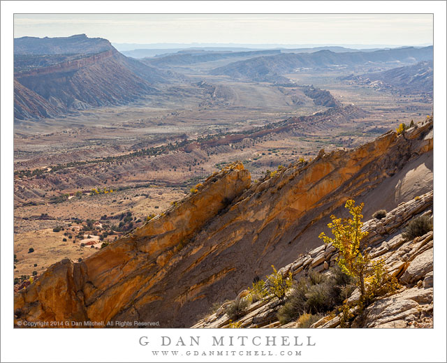
I’m going to double-up here and share two photographs in a single post — both are from the Waterpocket Fold (Strike Valley) area just to the east of Capitol Reef National Park.

Waterpocket Fold, Utah

Waterpocket Fold, Utah. Capitol Reef National Park, Utah. October 22, 2014. © Copyright 2014 G Dan Mitchell – all rights reserved.

Utah’s Waterpocket fold, viewed from high in the southern part of Capitol Reef National Park

The “Waterpocket Fold” is a gigantic geologic formation in Utah, a good portion of which runs the length of Capitol Reef National Park and beyond. As I understand it, the formation is a monocline, where strata change depth at a fairly steep angle, and subsequent erosion has worn away and exposed these strata in amazing ways, especially where the up-trending layers end. This photograph, made from a high point along the ridge of Capitol Reef, looks south into the waterpocket valley as it bends and continues to head south.

Canyon with Cottonwood Trees

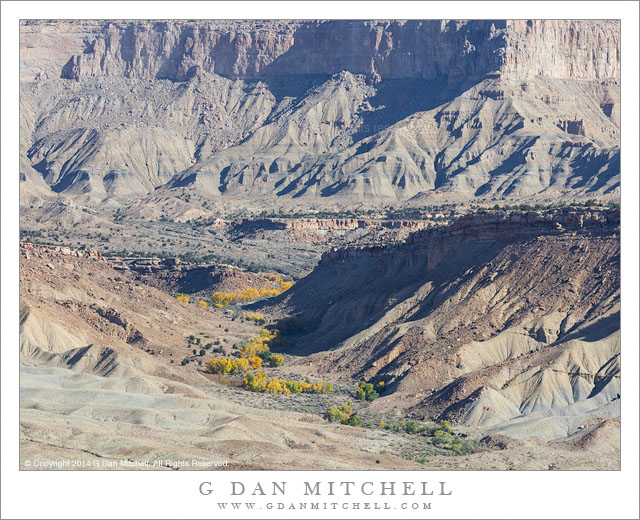
Canyon With Cottonwood Trees. Waterpocket Fold, Utah. October 22, 2014.© Copyright 2014 G Dan Mitchell – all rights reserved.

Cottonwood trees with autumn foliage follow a wash up a canyon toward Waterpocket Fold area cliffs

This photograph looks to the east across the strike valley of the Waterpocket Fold feature from along the ridge of Capitol Reef. A wash (which may be Bitter Creek?) winds away and upwards toward the giant cliffs along the east side of the Valley. The scene illustrates, I think, quite a few common features of this terrain. It is quite arid and rugged — except that along the bottom of the wash, which periodically floods, a long grove of cottonwood trees and other vegetation has taken hold and seems to thrive.


G Dan Mitchell is a California photographer and visual opportunist whose subjects include the Pacific coast, redwood forests, central California oak/grasslands, the Sierra Nevada, California deserts, urban landscapes, night photography, and more.
Blog | About | Flickr | Twitter | FacebookGoogle+ | 500px.com | LinkedIn | Email

Text, photographs, and other media are © Copyright G Dan Mitchell (or others when indicated) and are not in the public domain and may not be used on websites, blogs, or in other media without advance permission from G Dan Mitchell.
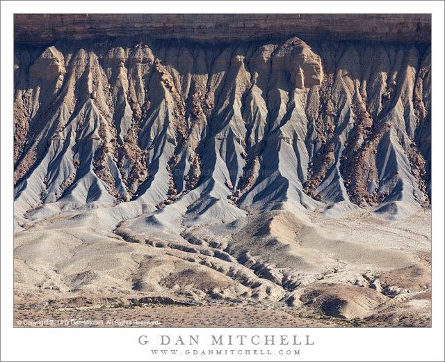
Erosion Gullies, Waterpocket Fold

Erosion Gullies, Waterpocket Fold

Erosion Gullies, Waterpocket Fold. Capitol Reef National Park, Utah. October 22, 2014. © Copyright 2014 G Dan Mitchell – all rights reserved.

Eroded gullies at the base of cliffs along the east side of the Waterpocket Fold Valley, Utah

The Waterpocket Fold is a huge geological feature of Utah that essentially defines Capitol Reef National Park, creating the deep valley along its east flank, the uplift that created the high ridge that runs the length of the park, and the many exposed edges of rock strata found all over the park. Its westward-trending uplift is also a reason why you may be challenged to get a traditional golden hour spectacular western sky photograph from along the west side of the park — the land continues to trend upward to the west there.

It is easy to overlook the feature if you are within the intimate landscape of many of the popular portions of the park, where you may be more attracted to washes and canyons and trees and nearby cliffs. But if you head down the east side of the park — on a long gravel road — the immensity of this feature becomes very obvious. This photograph was made from a high point in this part of the park, at a location that sits on the edge of this big valley and offers views to the north, east, and south. Here the view is straight across the valley toward the base of the tall ridge on the opposite side, below which there are steep gullies in the material that has eroded from the faces above, a bit of which is visible at the top of the frame.

And, yes, it is a double post day.


G Dan Mitchell is a California photographer and visual opportunist whose subjects include the Pacific coast, redwood forests, central California oak/grasslands, the Sierra Nevada, California deserts, urban landscapes, night photography, and more.
Blog | About | Flickr | Twitter | FacebookGoogle+ | 500px.com | LinkedIn | Email

Text, photographs, and other media are © Copyright G Dan Mitchell (or others when indicated) and are not in the public domain and may not be used on websites, blogs, or in other media without advance permission from G Dan Mitchell.