Tag Archives: great western divide

Granite Cliffs, Alpine Lake

Granite Cliffs, Alpine Lake
Rocks from vertical cliffs line the base of a deep blue alpine lake

Granite Cliffs, Alpine Lake. Sequoia National Park, California. August 6, 2008. © Copyright 2008 G Dan Mitchell – all rights reserved.

Rocks fallen from vertical cliffs line the edges of a deep blue alpine lake

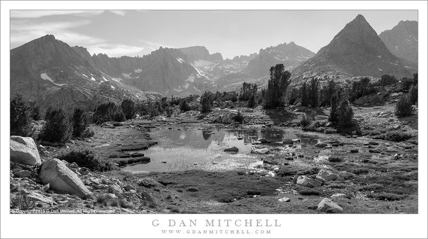
As I write this tonight for posting tomorrow, winter is over and spring is a few hours old. It is perhaps for that reason — the start of spring and the inevitability of summer — that I found myself looking though some old photograph files from a summer about eight years in the past. There is a practical reason to revisit the old files from time to time; I often find photographs that now look pretty interesting that I apparently skipped over originally, for one reason or another. But it is also an opportunity to revisit the older memories as well, since looking at the photographs brings back the recall of many other details of such Sierra trips.

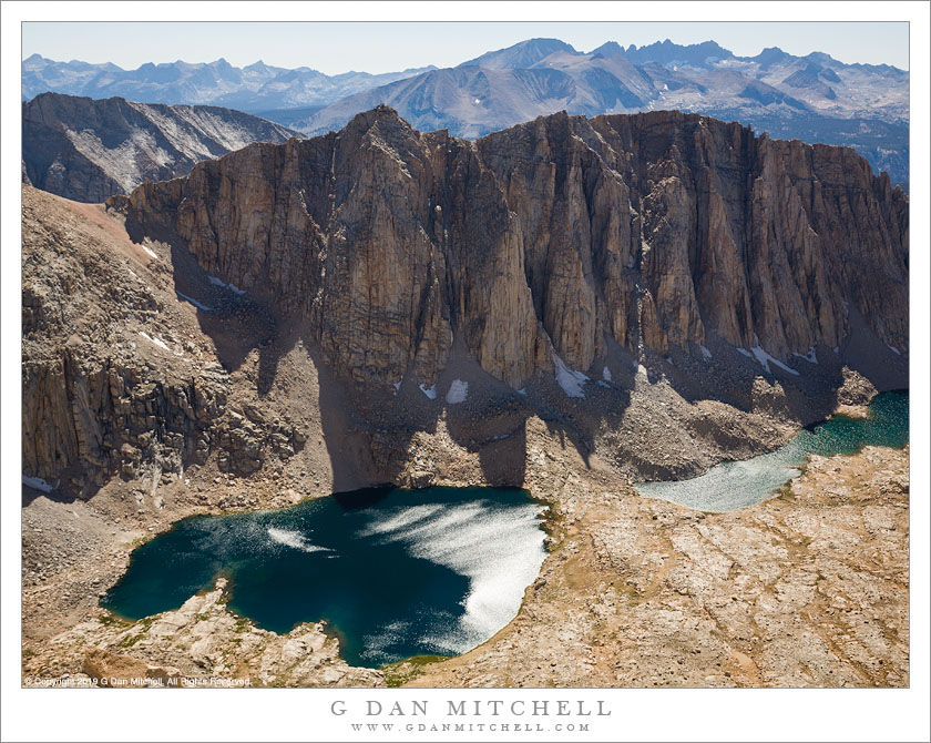
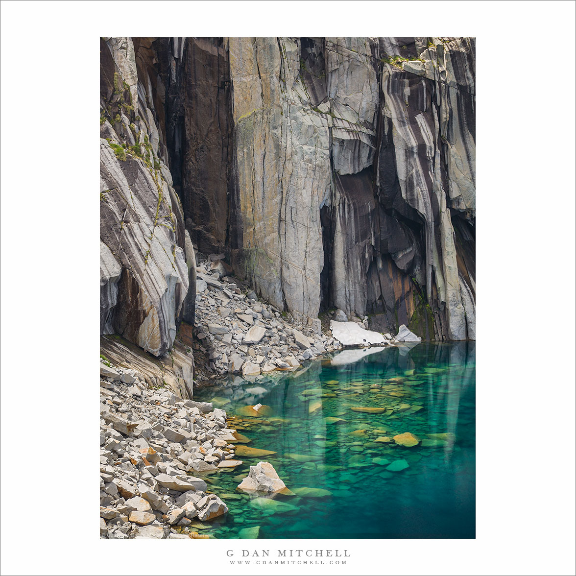
On this trip I crossed the Southern Sierra from west to east with a small group of long-time trail friends. I am not sure why, but I had not been back on this trail in the decades since my first visit — so I was excited to revisit this spectacular route. Today I began tracking the progress of the trip via the old photographs, starting on the first day and looking at photograph up through day three, when we climbed from a beautiful lake to cross the Kaweah Mountains and head east. I came to this photograph, which is a vertical orientation interpretation on a scene in another of my photographs that may be somewhat recognizable. At the time when I made the original print I think I must have committed to the horizontal format and, thus, put the vertical on the back burner. but today I decided that I like this version, too, with a bit less emphasis on the water and a bit more on the vertical thrust of the rocky walls.


G Dan Mitchell is a California photographer and visual opportunist. His book, “California’s Fall Color: A Photographer’s Guide to Autumn in the Sierra” is available from Heyday Books and Amazon.
Blog | About | Flickr | Twitter | FacebookGoogle+ | 500px.com | LinkedIn | Email


All media © Copyright G Dan Mitchell and others as indicated. Any use requires advance permission from G Dan Mitchell.

Timberline Lake, Rugged Ridges

Timberline Lake, Rugged Ridges
A small timberline lake sits on a bench in front of rugged summits of the Great Western Divide

Timberline Lake, Rugged Ridges. Sequoia National Park. August 2, 2010.© Copyright 2010 G Dan Mitchell – all rights reserved.

A small timberline lake sits on a bench in front of rugged summits of the Great Western Divide

This is yet another in series of photographs from a 2010 backpack trip into the far reaches of the Kern River drainage in Sequoia National Park. For reasons that I’m not certain that I can identify, last week I decided to go back and take a look at these old photographs, few of which have not previously shared. They exemplify one of the reasons that I rarely delete old raw files, even if they don’t look all that interesting at the time — too often I return to the photographs months or even years later and find things that make me glad I kept them. Sometimes I find photographs that I simply passed over or didn’t understand at the time, and other times I simply have the joy of reliving an experience that had largely slipped from my mind.

On this trip a group of close friends with whom I have backpacked for years were on yet another summer adventure, this time into the remote backcountry of Sequoia National Park. We traveled a popular but long trail over several very high passes to get to the general area, and then we left that trail and headed west to a place that is visited much less frequently, a location tucked back up beneath the Great Western Divide. I had touched the edges of this area a few times before but never had gone straight there — and now I wish that I had visited earlier, as we found an infrequently visited region of monumental mountains and valleys and a stupendous alpine setting. This photograph overlooks a lake on a bench in an area where we camped, and the view extends westward toward the crest of the divide.


G Dan Mitchell is a California photographer and visual opportunist. His book, “California’s Fall Color: A Photographer’s Guide to Autumn in the Sierra” is available from Heyday Books and Amazon.

Blog | About | Flickr | FacebookEmail

Links to Articles, Sales and Licensing, my Sierra Nevada Fall Color book, Contact Information.


All media © Copyright G Dan Mitchell and others as indicated. Any use requires advance permission from G Dan Mitchell.

Hitchcock Lakes

High Lakes, Trail Crest
Terrain to the west of Whitney Trail Crest

Hitchcock Lakes from the Mt. Whitney Trail. Sequoia National Park, California. August 11, 2008. © Copyright 2008 G Dan Mitchell – all rights reserved.

Hitchcock Lakes seen from the Mt. Whitney Trail.

I climbed Mount Whitney – again – on August 11, 2008 after crossing the Sierra Nevada from west to east on Sequoia National Park’s High Sierra Trail. I’ve been to the summit a couple times in the past. Last year I swore I would not climb this peak again, mainly because there are so many other beautiful things to see in the Sierra and I didn’t feel a strong need to do this again. But my friends proposed a trip that concluded with the Whitney ascent, and I couldn’t say no.

A traditional starting point for ascents from the west is Guitar Lake, a small – and often somewhat crowded – little lake in a truly alpine setting just above timberline. From here the trail ascends the valley containing these lakes, leading to the junction with the trail from the east side just before reaching the ridge, and then a lateral trail traverses out to the summit of Whitney.

It won’t surprise anyone if I say that there are some wonderful panoramas to be seen from almost any point on this climb. One of my favorite is this view back across the valley from which the trail ascended and towards high elevation Hitchcock Lakes and the ridge between them and the Crabtree Basin beyond.

(Oddly, I often find the summit view to be photographically uninspiring, and I usually end up just making some “record” photos there and a perfunctory pano or two.)


G Dan Mitchell is a California photographer and visual opportunist whose subjects include the Pacific coast, redwood forests, central California oak/grasslands, the Sierra Nevada, California deserts, urban landscapes, night photography, and more.
Blog | About | Flickr | Twitter | FacebookGoogle+ | 500px.com | LinkedIn | Email

Text, photographs, and other media are © Copyright G Dan Mitchell (or others when indicated) and are not in the public domain and may not be used on websites, blogs, or in other media without advance permission from G Dan Mitchell.

Evening and Shoreline Trees, Moraine Lake

Evening and Shoreline Trees, Moraine Lake
Evening and Shoreline Trees, Moraine Lake. Sequoia National Park, California. August 7 2008. © Copyright G Dan Mitchell – all rights reserved.

Evening along the tree-lined shore of Moraine Lake in Sequoia National Park, California.

Moraine Lake is located on the Chagoopa Plateau in the Sierra Nevada backcountry of Sequoia National Park, between Big Arroyo and the deep trench of Kern Canyon. Aside from being a bit windy when I’ve been there, it is a very peaceful spot – and a good warm place (relatively speaking) to swim. No surprise given its name, the opposite shore is formed by a lateral moraine that must have come from a glacier traveling down Big Arroyo, and there are lots of rocks everywhere. In fact, along the near shoreline they form a couple of little peninsulas that enclose shallows cut off from the main lake and which support a few trees like those in this photograph.

Most recently I was here in in early August of 2008, when I and a group of friends camped for a night on our trip from Crescent Meadow to Whitney Portal via the High Sierra Trail. Technically (OK, literally), Moraine Lake is not “on” the High Sierra Trail, being instead on a lateral loop that leaves the HS Trail on the Chagoopa Plateau to drop down to the lake, and which then continues to the loop to rejoin a few miles later. Oddly, it seems to me that most people who hike through here probably do take the alternative route past Moraine, with the exception of some hard-core hikers who walk far enough in a day to not need to camp on the Plateau.

keywords: evening, shore, shoreline, trees, moraine, lake, high, sierra, trail, nevada, backpack, hike, camp, clouds, reflection, rock, mountain, alpine, great western divide, peak, forest, grass, quiet, landscape, california, usa, sequoia, national park, stock, blue, sky