Tag Archives: national park

Clearing Storm, Panamint Range

Clearing Storm, Panamint Range

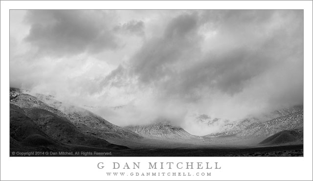
Clearing Storm, Panamint Range. Death Valley National Park, California. April 2, 2014. © Copyright 2014 G Dan Mitchell – all rights reserved.

A clearing snow storm in the Panamint Mountains above Wildrose Canyon, Death Valley National Park

I seem to have a knack for encountering “interesting” weather in Death Valley. The first time I visited the park, on an early April trip back in the late 1990s, I encountered light snow at Scotty’s Castle, an extremely cold wind storm that forced a retreat from the back-country near Teakettle Junction, and a big dust storm at Stovepipe Wells. Since then I’ve experienced a number of dust storms, heavy rain, sub-freezing temperatures, more snow, and plenty of wind. If you are hoping to visit the park for its more typical hot weather, you might want to avoid times when I’m there! Of course, I often visit around the beginning of April, and this seems to be a time of wildly varied conditions in this park—the time of wind storms, and a season when you might see the last Pacific winter storms or the first really warm weather.

On this year’s early April visit things leaned more in the direction of winter-like conditions. As a series of welcome Pacific storms came through there were plenty of clouds, cooler temperatures, strong winds, and some precipitation. The plan on this morning was to start at a very high overlook in the Panamint Range, from which expansive morning vistas are often possible. We were there before sunrise… but it was cloudy and becoming cloudier. There was enough light for some photography, but we also became aware that snow was starting to fall on some of the higher peaks. After an hour or so at this location we retreated to a high, broad, sage-filled valley and continued to watch the clouds close in and the snow spread along other nearby ridges. Not wanting to miss the unusual conditions we headed up into Wildrose Canyon, getting as far as the charcoal kilns before the falling snow convinced me that we shouldn’t go any further. We worked our way back down the canyon where the storm began to temporarily clear from the ridge of the Panamint Mountains.

G Dan Mitchell is a California photographer and visual opportunist whose subjects include the Pacific coast, redwood forests, central California oak/grasslands, the Sierra Nevada, California deserts, urban landscapes, night photography, and more.
Blog | About | Flickr | Twitter | FacebookGoogle+ | 500px.com | LinkedIn | Email

Text, photographs, and other media are © Copyright G Dan Mitchell (or others when indicated) and are not in the public domain and may not be used on websites, blogs, or in other media without advance permission from G Dan Mitchell.

Trees, Granite, and Sky Near Olmsted Point

Trees, Granite, and Sky Near Olmsted Point - Sunset light on a trees and weathered granite slabs above Olmsted Point, Yosemite National Park
Sunset light on a trees and weathered granite slabs above Olmsted Point, Yosemite National Park

Trees, Granite, and Sky Near Olmsted Point. Yosemite National Park, California. September 16, 2012. © Copyright 2012 G Dan Mitchell – all rights reserved.

Sunset light on a trees and weathered granite slabs above Olmsted Point, Yosemite National Park.

This is another “opportunistic photograph” made on my way back home from a three-day mid-September backpacking trip in the eastern Sierra. We had finished up at the McGee Creek trailhead around 3:00, gotten cleaned up, headed into Mammoth Lakes for a celebratory post-trip Mexican dinner, and I found myself on the road back toward the Bay Area close to 5:00 p.m. I figured that this might well get me over Tioga Pass close to 6:00 p.m. and allow me to find some place with suitably interesting subjects and light before the sun went down. I crossed the pass on schedule, then passed through Tuolumne Meadows (where I had photographed a few days earlier), and decided that it would be a good idea to go a bit further west – and a bit closer to home! – before stopping to shoot.

Most of the interesting light was gone when I got to Tenaya Lake, so I figured I might as well head up to Olmsted Point and see what I could find. Obviously, the classic “back side” view of Half Dome is there, as well as the view back toward Tenaya Lake and Mount Conness. I stopped and picked out an “insurance” shot of Half Dome, though the light initially didn’t look all that spectacular. While talking to some other visitors I missed a bit of lovely light on Conness, though I probably didn’t have a long enough lens anyway. (I was traveling light, with only the limited set of equipment that I take backpacking.) However, besides the obvious there is quite a bit of other interesting stuff to see right around Olmsted, especially late in the day when the last light slants across low ridges to the west and picks up bits and pieces of the landscape – a tree here, a rock there. This little vignette was high on the granite slabs above Olmsted, and as a bit of late light glanced across the rocks and trees, an angled bit of cloud passed by, mirroring the angle of the ridge.

G Dan Mitchell is a California photographer whose subjects include the Pacific coast, redwood forests, central California oak/grasslands, the Sierra Nevada, California deserts, urban landscapes, night photography, and more.
Blog | About | Flickr | Twitter | FacebookGoogle+ | 500px.com | LinkedIn | Email

Text, photographs, and other media are © Copyright G Dan Mitchell (or others when indicated) and are not in the public domain and may not be used on websites, blogs, or in other media without advance permission from G Dan Mitchell.

One Green Leaf

One Green Leaf, Capitol Reef National Park
“One Green Leaf” — One green leaf on a bed of brown and tan autumn leaves in a desert wash, Capitol Reef National Park

My two October trips to photograph in Utah extended my ongoing education about the place, and one of the locations about which I had and still have the most to learn is Capitol Reef National Park. My encounter with this park, in 2012, was a bit superficial, though my excuse is that we were only passing through on our way to another place. All I saw was the short highway drive that passed through the park via the Fruita District — the rest of the park remained a complete mystery. In October I was there twice. On the first visit I was in the area enough to start to get a bit of a feel for the place, though I mostly still stuck to popular and accessible areas, with the addition of a bit of hiking and a long drive on gravel roads down the less-visited side of the park. On the second visit I learned and saw a bit more – enough to convince me that there is much more to this park and that I want to return.

I made this photograph in a short slot canyon in an out-of-the way area of the park. We drove there on a very cold morning and headed into the canyon while the temperature still hovered around freezing. There was no one else there, and we barely even saw anyone else on the long drive to get there. The little canyon itself was quite beautiful and full of interesting surprises – juxtapositions of glowing red-orange walls and shaded blue-purple walls, brilliantly colorful gambel oak leaves, large sandstone faces and walls, and more. As I investigate a place like this I try to let my eyes roam beyond the first things I see, and try to also see smaller things that could easily be missed. Here I happened to look down at my feet – sometimes a good thing to do! – and see that the floor of the stream bed carpeted with oak and other leaves that had recently fallen, and this batch of brown and tan leaves held one that was still green.


G Dan Mitchell is a California photographer and visual opportunist. His book, “California’s Fall Color: A Photographer’s Guide to Autumn in the Sierra” (Heyday Books) is available directly from him.

G Dan Mitchell: Blog | Bluesky | Mastodon | Substack Notes | Flickr | Email


All media © Copyright G Dan Mitchell and others as indicated. Any use requires advance permission from G Dan Mitchell.

Trillium Plants, Redwood Forest

Trillium Plants, Redwood Forest

Trillium Plants, Redwood Forest. Muir Woods National Monument, California. March 21, 2009. © Copyright 2009 G Dan Mitchell – all rights reserved.

Trillium plants beneath the redwood forest canopy at Muir Woods National Monument.

This is another of the previously overlooked photographs from a few years back, this time from Muir Woods National Monument in the Golden Gate National Recreation Area. I visit there frequently, and on this occasion I arrived just after the bloom of the trillium flowers had finished, but when the plants were still growing strong.

G Dan Mitchell is a California photographer whose subjects include the Pacific coast, redwood forests, central California oak/grasslands, the Sierra Nevada, California deserts, urban landscapes, night photography, and more.
Blog | About | Flickr | Twitter | FacebookGoogle+ | 500px.com | LinkedIn | Email

Text, photographs, and other media are © Copyright G Dan Mitchell (or others when indicated) and are not in the public domain and may not be used on websites, blogs, or in other media without advance permission from G Dan Mitchell.